
Praden
| Praden | |
|---|---|
 |
|
| State : |
|
| Canton : |
|
| Region : | Plessure |
| Political community : | Tschiertschen-Praden |
| Postal code : | 7063 |
| former BFS no. : | 3914 |
| Coordinates : | 763 501 / 188 192 |
| Height : | 1161 m above sea level M. |
| Area : | 6.40 km² |
| Residents: | 106 (December 31, 2007) |
| Population density : | 17 inhabitants per km² |
| Website: | www.tschiertschen-praden.ch |
 Praden |
|
| map | |
 |
|
Praden ( Romansh: ) was, until 31 December 2008, a municipality in the former county Churwalden , district Plessur of the canton of Grisons in Switzerland .
On January 1, 2009, Praden merged with the Tschiertschen community to form the new Tschiertschen-Praden community .
coat of arms
Description : Split of gold and blue, blue club on stake in gold, six-pointed golden star in blue. The club refers to the former affiliation to the Langwies court , the star to the Churwalden district. Colors of the Ten Court League .
geography
The former municipality is located five kilometers (as the crow flies) southeast of Chur on the left side of the Schanfigg valley . The territory extended south of the deeply incised Plessur (around 700 m ), which forms the municipal boundary for four kilometers between the mouths of the Pajüeltobel and Steinbachtobel , on the northern slope of the Gürgaletsch . The highest point at 2075 m was reached between its summit and the yoke , which runs as a mule track into the Churwalden valley. The village of Praden, located about 400 m above the river on a slope, consists of the western part Ausserpraden (1135 m above sea level) and the eastern part Innerpraden (1161 m), which are separated by the Sagentobel .
Of the entire former municipal area of 642 hectares , 436 hectares are covered by forest and wood. At least 168 hectares can be used agriculturally (mainly alpine meadows). In addition to 31 hectares of unproductive area - mostly mountains - there are also seven hectares of settlement area.
Neighboring communities were Churwalden , Maladers , Calfreisen , Castiel , Lüen and Tschiertschen .
history
Mentioned in 1157 as Pradis (name from Latin pratum , "meadow"), Walsers from Langwies settled permanently around 1300 . Logically, Praden belonged in the Drei Bünden as a neighborhood to the Langwies court of the Ten Courts Federation and only came to Churwalden in 1851, when today's districts were created.
population
| year | 1850 | 1900 | 1950 | 1980 | 2000 | 2005 |
| population | 144 | 131 | 98 | 51 | 115 | 114 |
Of the 113 residents, 106 were Swiss nationals (as of the end of 2004).
Economy and Transport

In the past, the Pradner lived almost exclusively from agriculture, whereby the climatic conditions allowed arable and fruit growing as well as the dominant cattle breeding. After the population had been declining for over a hundred years, the village was able to reverse the trend in the 1980s. Since then it has developed into a popular residential community in the catchment area of the canton's capital. Praden hardly played a role in the tourist boom in the area ( Arosa , Lenzerheide , Tschiertschen); the place itself offers only 21 jobs (as of 2000–01).
Tschiertscherstrasse runs through Praden . The village is connected to the public transport network by the Chur – Tschiertschen post bus line.
Attractions
The reformed village church is a listed building .
Personalities
The architect Meinrad Lorenz came from Praden, who shaped many of the Rhaetian Railway's railroad structures that were built before the First World War . Oliver Fuchs , the former head of entertainment at the Second German Television (ZDF), also grew up in Praden .
gallery

Reformed Church Praden and next to it the old school house

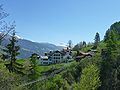
Praden, looking north
View from the north

Stable above the village

Church in Praden.


_via_Ranculier_en_Praden_naar_Tschiertschen_06.jpg)
literature
- Erwin Poeschel : The art monuments of the canton of Graubünden II. The valley communities Herrschaft, Prättigau, Davos, Schanfigg, Churwalden, Albula valley. (= Art Monuments of Switzerland. Volume 9). Edited by the Society for Swiss Art History GSK. Bern 1937. DNB 811066703 .
- The municipalities of the canton of Graubünden. Chur / Zurich, 2003. ISBN 3-7253-0741-5 .
- Peter Masüger: From Old Rhaeto-Romanic to "Tschalfiggerisch" , in: Terra Grischuna, 48th year, issue 1, Terra Grischuna Verlag, Chur 1990, ISSN 1011-5196 .
- Christian Patt: Schanfigger Words - A supplement to the Davos dictionary, Verlag Walservereinigung Graubünden, Chur 1986.
- C. Fischer: Land and people in the valley Schanfigg , Manatschal Ebner & Cie., Chur 1905.
Web links
- Official website of the former municipality of Praden
- Jürg Simonett: Praden. In: Historical Lexicon of Switzerland .
Individual evidence
- ↑ Aroser Zeitung of November 8, 2013, p. 17.
Arosa | Chur | Churwalden | Haldenstein | Tschiertschen-Praden
Former municipalities: Calfreisen | Castiel | Hof Chur | Langwies | Lüen | Maladers | Malix | Molinis | Pagig | Parpan | Peist | Praden | St. Peter-Pagig | St. Peter | Tschiertschen
Canton of Graubünden | Regions of the Canton of Graubünden | Municipalities of the Canton of Graubünden