
Churwalden district
| Churwalden | |
|---|---|
_wappen.svg)
|
|
| Basic data | |
| Canton : | Graubünden (GR) |
| District : | Plessure |
| Main town : | Churwalden |
| Surface: | 76.28 km² |
| Residents: | 1523 December 31, 2009 |
| Population density : | 20 inhabitants per km² |
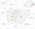
| map | |
 |
|
The district of Churwalden together with the districts of Chur and Schanfigg forms the district of Plessur in the canton of Graubünden in Switzerland until December 31, 2015 . The seat of the district office was in Churwalden . The districts were abolished by the Graubünden regional reform.
Communities
The district was made up of the following communities:
| coat of arms | Name of the parish | Population (Dec. 2009) |
Area in km² |
BFS no |
|---|---|---|---|---|
| Churwalden | 1949 | 48.54 | 3911 | |
| Tschiertschen-Praden | 305 | 27.74 | 3932 |
Changes in the community since 2000
Municipalities until 2008

Municipalities until 2009


Mergers
- 2009: Tschiertschen and Praden → Tschiertschen-Praden
- 2010: Churwalden , Malix and Parpan → Churwalden
Web links
Commons : Kreis Churwalden - Collection of images, videos and audio files
Districts of the Plessur district