
Tschiertschen
_via_Ranculier_en_Praden_naar_Tschiertschen_026.jpg)
| Tschiertschen | |
|---|---|
 |
|
| State : |
|
| Canton : |
|
| Region : | Plessure |
| Political community : | Tschiertschen-Praden |
| Postal code : | 7064 |
| former BFS no. : | 3915 |
| Coordinates : | 765.42 thousand / 187529 |
| Height : | 1350 m above sea level M. |
| Area : | 21.34 km² |
| Residents: | 212 (December 31, 2007) |
| Population density : | 10 inhabitants per km² |
| Website: | www.tschiertschen-praden.ch |
 Tschiertschen |
|
| map | |
 |
|

Tschiertschen ( ) was, until 31 December 2008, a municipality in the former county Churwalden , district Plessur of the canton of Grisons in Switzerland .
On January 1, 2009 Tschiertschen merged with the municipality of Praden to form the new municipality of Tschiertschen-Praden .
geography

Tschiertschen is located on the left, southern side of the valley of the Schanfigg , seven kilometers (as the crow flies) southeast of Chur . The municipality extends from the deeply cut Plessur ( 770 m above sea level ) to the peaks of the Weisshorn chain . Tschiertschen only takes part in the course of the river itself for a few hundred meters between the mouths of the Pajüelbach and Sagenbach ; Up the slope, however, the territory of the former municipality widened rapidly and encompassed almost the entire catchment area of the two streams, with the Sagenbach valley branching out at Kote 1320 into the two source valleys Farur and Urden . The eastern boundary ran from the Aroser Weisshorn (2653 m) via Plattenhorn and Tschirpen to the Parpaner Weisshorn , which is the southernmost and at 2824 m above sea level. M. also marks the highest point of the municipality. From there the border led over the Parpaner Schwarzhorn (2683 m) to the Täliflue upstream of the Gürgaletsch (2441 m) , the northwestern branch of the Lenzer Horn - Rothorn chain. In addition to the clustered village of Tschiertschen, located between Pajüel- and Sagenbach on the northeast sloping slope, the community also included the farm groups Clüs , Fups and Furgglis and the alpine settlements in Farur and Urdental .
Neighboring communities were Praden , Lüen , Molinis , Arosa , Vaz / Obervaz , Parpan and Churwalden .
coat of arms
Description : A golden post in blue, covered by a six-pointed blue star, and two golden ears of wheat. After the municipal seal of 1825, which showed a split shield with a star in alternating colors. The star is the coat of arms of the Churwalden district, to which the ears of corn were added at the request of the municipality. Colors of the Ten Court League .
history
Originally the place, mentioned as Cercene in the 8th century, was settled by Romanes , which is still remembered by many field names today. The property of the Churwalden monastery , which has been occupied since 1222, established the affiliation to the Strassberg rulership, later to the Churwalden court of the Ten Courts Association. Tschiertschen joined the Reformation around 1530 ; At the end of the 16th century there was a transition from Romance to German.
population
Tschiertschen has around 220 mostly Reformed residents. The majority of the population lives directly or indirectly from tourism , mainly in the winter season.
| year | 1850 | 1900 | 1950 | 2000 | 2005 |
| population | 124 | 139 | 174 | 225 | 219 |
politics
The last mayor of Tschiertschen was Werni Walser.
Economy and Infrastructure
In the village there is a primary school , an evangelical rectory , the office of the tourist organization Schanfigg-Tourismus , two hotels and a multi-purpose hall.
Even before the merger, there were traditionally close ties with the neighboring municipality of Praden. Local government, fire brigade and school association were organized collectively.
traffic

In the years 1893-1894 the Tschiertscherstrasse was built from Chur via Passugg and Praden to Tschiertschen. The community is connected to the public transport network with the Chur – Tschiertschen post bus line.
tourism


Tschiertschen offers 25 kilometers of slopes in winter with two new four-person chairlifts ( Waldstafel and Hüenerchöpf , 2001) and two ski lifts ( Gürgaletsch and Jochalp ). The Arosa - Lenzerheide ski area connection, which was implemented in winter 2013/14 , was controversial on site. Serious interference in the landscape of the Farur and Urdental was feared by the opponents . The proponents, on the other hand, underlined the considerable tourist advantages for the entire region, from which Tschiertschen could also benefit in a possible future connection to this new ski arena.
Attractions
Wooden houses in the Walser building tradition characterize the compact village center. Typical of Tschiertschen are the artfully painted house sayings on almost all older houses under the respective roof gables , almost all of which are taken from the Bible. The reformed church is a Gothic building from the 15th century.
Historic sawmill
The historic Sagi Tschiertschen sawmill is powered by the water of the Sagäbach. The sawmill was built in 1920 and renovated in 1989. Demonstrations take place in May – September.
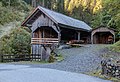
building
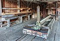
Wood sawing machine

Wood saw machine detail

Wood saw machine detail


Personalities
- Georg Jäger (* 1943), founder of the Graubünden Institute for Cultural Research
- Peter Zinsli (* 1934; † 2011), composer, Kapellmeister and Schwyzerörgelist
literature
- Erwin Poeschel : The art monuments of the canton of Graubünden II. The valley communities Herrschaft, Prättigau, Davos, Schanfigg, Churwalden, Albula valley. (= Art Monuments of Switzerland. Volume 9). Edited by the Society for Swiss Art History GSK. Bern 1937, DNB 811066703 .
- The municipalities of the canton of Graubünden. Chur / Zurich 2003, ISBN 3-7253-0741-5 .
- Peter Masüger: From Old Rhaeto-Romanic to «Tschalfiggerisch». In: Terra Grischuna. 48th year, issue 1, Terra Grischuna Verlag, Chur 1990, ISSN 1011-5196 .
- Christian Patt: Schanfigger Words - A supplement to the Davos dictionary. Walservereinigung Graubünden publisher, Chur 1986.
- Hans Danuser , Walser Association Graubünden (ed.): Old ways in Schanfigg. Publishing house Walser Association Graubünden, Splügen 1997.
- E. Rud: The Schanfigg. Buchdruckerei AG Arosa, Arosa around 1920.
- C. Fischer: Land and people in the Schanfigg valley. Manatschal Ebner & Cie., Chur 1905.
Web links
- Jürg Simonett: Tschiertschen. In: Historical Lexicon of Switzerland .
- Evangelical parish Steinbach
- Information on what is happening in Tschiertschen
Individual evidence
- ↑ Tschiertschen dreams of a ski slope through Urdental. In: Südostschweiz.ch. October 29, 2014, accessed November 8, 2014 .
Arosa | Chur | Churwalden | Haldenstein | Tschiertschen-Praden
Former municipalities: Calfreisen | Castiel | Hof Chur | Langwies | Lüen | Maladers | Malix | Molinis | Pagig | Parpan | Peist | Praden | St. Peter-Pagig | St. Peter | Tschiertschen
Canton of Graubünden | Regions of the Canton of Graubünden | Municipalities of the Canton of Graubünden