
Plessur district
| Plessur district | |
|---|---|
| Basic data | |
| Country: |
|
| Canton : |
|
| Main town : | Chur |
| Area : | 266.75 km² |
| Residents: | 40,707 (December 31, 2015) |
| Population density : | 153 inhabitants per km² |
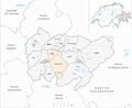
| map | |
 |
|
The district of Plessur ( Romansh ) was an administrative unit of the canton of Graubünden in Switzerland until December 31, 2015 . The former district is named after the river Plessur that crosses it . It was replaced by the Plessur region on January 1, 2016 .
The following districts and communities belonged to the Plessur district:
As of December 31, 2015
| District of Chur | |||
|---|---|---|---|
| coat of arms | Name of the parish | Population (December 31, 2018) |
Area in km² |
| Chur | 35,897 | 28.09 | |
| Churwalden district | |||
|---|---|---|---|
| coat of arms | Name of the parish | Population (December 31, 2018) |
Area in km² |
| Churwalden | 1949 | 48.54 | |
| Tschiertschen-Praden | 305 | 27.74 | |
| Schanfigg district | |||
|---|---|---|---|
| coat of arms | Name of the parish | Population (December 31, 2018) |
Area in km² |
| Arosa | 3131 | 154.79 | |
| Maladers | 519 | 7.59 | |
Changes in the community

Parishes until 1850

Municipalities until 2007
Municipalities until 2008

Municipalities until 2009

Municipalities until 2012

Municipalities until 2015


- 1851: Separation from Davos and change of district from Oberlandquart → Arosa district to Plessur district
- 1852: Merger of Chur and Hof Chur → Chur
- 2008: Merger of St. Peter and Pagig → St. Peter-Pagig
- 2009: Tschiertschen and Praden → Tschiertschen-Praden merger
- 2010: Merger of Churwalden , Malix and Parpan → Churwalden
- 2013: Merger of Arosa , Calfreisen Castiel , Langwies Lüen , Molinis , Peist and St. Peter-Pagig → Arosa
- 2016: District change: Haldenstein moves from the district → Landquart
Web links
- Official website of the Plessur District Court
- Jürg Simonett: Plessur. In: Historical Lexicon of Switzerland .
Albula |
Bernina |
Hinterrhein |
Imboden |
Inn |
Landquart |
Maloja |
Moesa |
Plessur |
Prättigau-Davos |
Surselva
Former districts of the canton of Graubünden until December 31, 2000:
Glenner |
Heinzenberg |
Oberlandquart |
Unterlandquart |
Val Müstair |
Vorderrhein
Canton of Graubünden | Districts of Switzerland | Municipalities of the Canton of Graubünden
Coordinates: 46 ° 49 '5.2 " N , 9 ° 36' 23.4" E ; CH1903: seven hundred sixty-five thousand four hundred nineteen / 187501