
District Inn
| District Inn | |
|---|---|
| Basic data | |
| Country: |
|
| Canton : |
|
| Main town : | Scuol |
| Area : | 1196.66 km² |
| Residents: | 9476 (December 31, 2015) |
| Population density : | 8 inhabitants per km² |
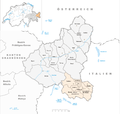
| map | |
 |
|
The district of Inn ( Rhaeto-Romanic ) was an administrative unit of the Canton of Graubünden in Switzerland until December 31, 2015 . It was replaced by the Engiadina Bassa / Val Müstair region .
The Inn district included the Lower Engadine and the Münstertal . The following districts and communities belonged to the district:
As of December 31, 2015
| Val Müstair district | |||
|---|---|---|---|
| coat of arms | Name of the parish | Population (December 31, 2018) |
Area in km² |
| Val Müstair | 1460 | 198.65 | |
| Ramosch district | |||
|---|---|---|---|
| coat of arms | Name of the parish | Population (December 31, 2018) |
Area in km² |
| Samnaun | 767 | 56.18 | |
| Valsot | 855 | 159.16 | |
| Sur Tasna County | |||
|---|---|---|---|
| coat of arms | Name of the parish | Population (December 31, 2018) |
Area in km² |
| Zernez | 1527 | 344.04 | |
| Suot Tasna county | |||
|---|---|---|---|
| coat of arms | Name of the parish | Population (December 31, 2018) |
Area in km² |
| Scuol | 4591 | 438.63 | |
Changes in the community

Municipalities until 1942

Parishes until 1969
Municipalities from 2001

Municipalities until 2008

Municipalities until 2012

Municipalities until 2014


- 1943: Name change from Fetan → Ftan
- 1943: Change of name from Remüs → Ramosch
- 1943: Change of name from Schleins → Tschlin
- 1943: Change of name from Schuls → Scuol / Schuls
- 1943: Change of name from Süs → Susch
- 1970: Name change from Scuol / Schuls → Scuol
- 2001: District change of all municipalities from the former Val Müstair district → Inn district
- 2009: Merger of Tschierv , Fuldera , Lü , Valchava , Santa Maria Val Müstair and Müstair → Val Müstair
- 2015: Merger Ardez , Ftan , Guarda , Scuol , Sent and Tarasp → Scuol
- 2015: Fusion Lavin , Susch and Zernez → Zernez
Web links
Albula |
Bernina |
Hinterrhein |
Imboden |
Inn |
Landquart |
Maloja |
Moesa |
Plessur |
Prättigau-Davos |
Surselva
Former districts of the canton of Graubünden until December 31, 2000:
Glenner |
Heinzenberg |
Oberlandquart |
Unterlandquart |
Val Müstair |
Vorderrhein
Canton of Graubünden | Districts of Switzerland | Municipalities of the Canton of Graubünden