
Val Müstair
| Val Müstair | |
|---|---|
_wappen.svg) |
|
| State : |
|
| Canton : |
|
| Region : | Engiadina Bassa / Val Müstair |
| BFS no. : | 3847 |
| Postal code : | 7532 Tschierv 7533 Fuldera 7534 Lü 7535 Valchava 7536 Santa Maria 7537 Müstair |
| Coordinates : | 828 762 / 165 541 |
| Height : | 1375 m above sea level M. |
| Height range : | 1220-3179 m above sea level M. |
| Area : | 198.65 km² |
| Residents: | 1460 (December 31, 2018) |
| Population density : | 7 inhabitants per km² |
| Website: | www.cdvm.ch |
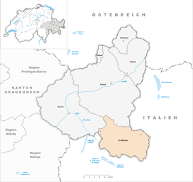
 Santa Maria Val Mustair |
|
| Location of the municipality | |
  |
|
Val Müstair ( ; German Münstertal ) is a municipality in Val Müstair in the Engiadina Bassa / Val Müstair region of the Swiss canton of Graubünden .
It was created on January 1, 2009 from the merger of the previously independent municipalities of Fuldera , Lü , Müstair , Santa Maria Val Müstair , Tschierv and Valchava . The community created by the merger is congruent with the district of the same name .
Colloquial language is the Romansh idiom Jauer .
geography

The community can be reached from Zernez in the Engadine via the Ofen Pass . The border with Vinschgau ( South Tyrol ) runs east of Müstair and also forms the Romansh-German language border. The local community Taufers in the Münstertal also belongs geographically to the Münstertal. The Umbrailpass leads from Santa Maria into Valtellina . The Rambach (Romanesque Rome ) flows through the valley .
The valley is divided into three parts, which are named as follows:
- Terzal d'Aint (inner third) with Tschierv, Fuldera and Lü
- Terzal d'Immez (middle third) with Valchava and Sta. Maria
- Terzal d'Oura (outer third) with Müstair
This division also corresponds to the three plateaus that can be found on the Swiss side of the valley.
Climate table
| Val Müstair (Santa Maria), 1981-2010 | ||||||||||||||||||||||||||||||||||||||||||||||||
|---|---|---|---|---|---|---|---|---|---|---|---|---|---|---|---|---|---|---|---|---|---|---|---|---|---|---|---|---|---|---|---|---|---|---|---|---|---|---|---|---|---|---|---|---|---|---|---|---|
| Climate diagram | ||||||||||||||||||||||||||||||||||||||||||||||||
| ||||||||||||||||||||||||||||||||||||||||||||||||
|
Average monthly temperatures and precipitation for Val Müstair (Santa Maria), 1981–2010
Source:
|
||||||||||||||||||||||||||||||||||||||||||||||||||||||||||||||||||||||||||||||||||||||||||||||||||||||||||||||||||||||||||||||||||||||||||||||||||||||
coat of arms
Description : The golden bust of Charlemagne in profile in blue.
The municipality continues to use the coat of arms of the Val Müstair district. The tradition names Karl the Great as the founder of the Münster monastery . The representation is based on the statue in the monastery church. The colors come from the monastery coat of arms.
Former communities in Val Müstair (down the valley)
- Tschierv
- Fuldera
- Lü
- Valchava
- Sta. Maria - the main town of the valley
- Müstair with the world cultural heritage Benedictine monastery St. Johann
Attractions
The most important sight is the Benedictine monastery of St. Johann on Via Maistra in Müstair .
Infrastructure
In Sta. Maria is home to the Val Müstair health center, one of the smallest hospitals in Switzerland.
literature
- Paul Eugen Grimm: Val Müstair. In: Historical Lexicon of Switzerland .
- Daniel Fleuti, Andrea Kippe: Val Müstair hiking world, hikes and snowshoe tours between the Ofen Pass and Glurns. Rotpunktverlag, Zurich 2018, ISBN 978-3-85869-780-6 .
- Padrot Nolfi: The Bündner Münstertal (= Swiss homeland books. Volume 5). Haupt, Bern 1958.
- Erwin Poeschel : The art monuments of the canton of Graubünden III. The valley areas Räzünser Boden, Domleschg, Heinzenberg, Oberhalbstein, Upper and Lower Engadine (= Swiss art monuments. Volume 11). Edited by the Society for Swiss Art History GSK. Bern 1940. DNB 760079625 .
- Albuin Thaler OMCap .: History of the Grisons Munster Valley . Sterzing 1925.
- Anna Tuor-Mall, Gion Anton Tuor: Yes, back then ... The simple life in Münstertal 100 years ago. Family biographical stories. Edited by the Biblioteca Jaura. Valchava 2018.
- William Wolfensberger: Heads and Hearts. Stories from the high valley. Schulthess & Co, Zurich 1930.
Web links
Individual evidence
- ↑ Permanent and non-permanent resident population by year, canton, district, municipality, population type and gender (permanent resident population). In: bfs. admin.ch . Federal Statistical Office (FSO), August 31, 2019, accessed on December 22, 2019 .
- ↑ Climate table. In: meteoschweiz.admin.ch. meteoschweiz, accessed on May 31, 2018 .
Samnaun | Scuol | Val Müstair | Valsot | Zernez
Former municipalities: Ardez | Ftan | Fuldera | Guarda | Lavin | Lü | Lüsai | Mustair | Ramosch | Santa Maria Val Müstair | Sent | Susch | Tarasp | Tschierv | Tschlin | Valchava | Valpaschun
Canton of Graubünden | Regions of the Canton of Graubünden | Municipalities of the Canton of Graubünden