Tschierv
| Tschierv | |
|---|---|
| State : |
|
| Canton : |
|
| Region : | Engiadina Bassa / Val Müstair |
| Political community : | Val Müstair |
| Postal code : | 7532 |
| former BFS no. : | 3845 |
| Coordinates : | 821 597 / 168 116 |
| Height : | 1660 m above sea level M. |
| Area : | 42.57 km² |
| Residents: | 172 (December 31, 2007) |
| Population density : | 4 inhabitants per km² |
| Website: | www.cdvm.ch |
|
Tschierv |
|
| map | |
Tschierv ( ; German and until 1943 officially Cierfs ) was until December 31, 2008 a political municipality in the Val Müstair district in the Inn district of the canton of Graubünden in Switzerland.
On January 1, 2009 Tschierv merged with the other Swiss municipalities in the valley ( Fuldera , Lü , Müstair , Santa Maria Val Müstair and Valchava ) to form the municipality of Val Müstair .
geography
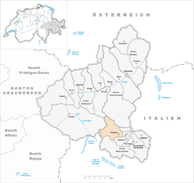
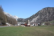
The municipality is the uppermost valley municipality of the Val Müstair (German Münstertal ) and is located east of the Ofen Pass . The districts of Aintasom-Tschierv (1693 m), Plaz (1660 m) and Orasom-Tschierv (1643 m) are located directly on the road that leads from the Ofen Pass into the valley . On the southern slope above is the oldest part of the village, Chasuras (1691 m). Part of Tschierv lies west of the pass, but is hardly inhabited. There is the Alp Buffalora and the customs station Buffalora . The highest point of this part of the municipality is the Piz d'Aint (2968 m) in the south and the Piz Tavü (3168 m) in the north of the pass road. The Val Nüglia also belongs to Tschierv . This forms part of the Swiss National Park .
Of the entire municipal area of almost 43 km², 1969 ha (= 46%) of mountain and 1143 ha (= 27%) are forested. 973 hectares of the usable soil of 1101 hectares are cultivated as alpine pastures . The remaining 43 hectares are settlement areas.
coat of arms
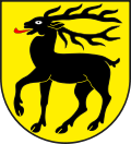
Description: In gold (yellow) a red armed, black stag . The name of the community is Romanesque for deer, so it is a talking coat of arms .
population
| year | 1835 | 1850 | 1900 | 1930 | 1941 | 1950 | 2000 | 2007 |
|---|---|---|---|---|---|---|---|---|
| Residents | 155 | 145 | 146 | 126 | 160 | 165 | 154 | 172 |
languages
By 1980, Romansh in the Jauer dialect was able to Romanise almost all of the German-speaking minority that had existed since the 19th century. Since then, the majority language has receded. In 1880 81.8%, in 1910 93%, 1941 92% and 1970 88% used Romansh as their main language. In 1990 92% and in 2000 92% of the population were able to communicate in this language. The following table shows the development over the past decades:
| languages | 1980 census | 1990 census | 2000 census | |||
|---|---|---|---|---|---|---|
| number | proportion of | number | proportion of | number | proportion of | |
| German | 6th | 4.48% | 18th | 12.24% | 29 | 18.83% |
| Romansh | 128 | 95.52% | 125 | 85.03% | 119 | 80.27% |
| Residents | 134 | 100% | 147 | 100% | 154 | 100% |
In addition to Romansh and German, Portuguese is one of the three most frequently used languages with 1.30% of the population (i.e. 2 people).
Religions and denominations
Around 1530 the residents switched to Protestant teaching.
Origin and nationality
Of the 172 residents at the end of 2005, 158 (= 92%) were Swiss citizens.
Attractions
The reformed village church is a listed building .
literature
- Erwin Poeschel : The art monuments of the canton of Graubünden III. The valley communities Räzünser Boden, Domleschg, Heinzenberg, Oberhalbstein, Upper and Lower Engadine. (= Art Monuments of Switzerland. Volume 11). Edited by the Society for Swiss Art History GSK. Bern 1940. DNB 760079625 .
- The municipalities of the canton of Graubünden. Chur / Zurich, 2003. ISBN 3-7253-0741-5
Web links
- Paul Eugen Grimm: Tschierv. In: Historical Lexicon of Switzerland .
- Website Val Müstair


