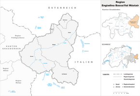
Engiadina Bassa / Val Müstair region
| Region Engiadina Bassa / Val Müstair region Lower Engadine / Munster |
|
|---|---|
| Basic data | |
| Country: |
|
| Canton : |
|
| Main town : | Scuol |
| FSO number : | 1843 |
| Area : | 1196.53 km² |
| Height range : | 988-3408 m above sea level M. |
| Residents: | 9200 (December 31, 2018) |
| Population density : | 8 inhabitants per km² |
| map | |
The Engiadina Bassa / Val Müstair region ( German Region Unterengadin / Münstertal ) is an administrative unit of the Canton of Graubünden in Switzerland , which was created on January 1, 2016 as a result of the regional reform.
The region includes the Lower Engadine and the Münstertal .
The Engiadina Bassa / Val Müstair region is identical to the Inn district that existed until December 31, 2015 . It includes the districts of Ramosch , Sur Tasna , Suot Tasna and Val Müstair , which were dissolved on December 31, 2015 .
Classification
The following communities belong to the Engiadina Bassa / Val Müstair region:
As of January 1, 2016
| coat of arms | Name of the parish | Population (December 31, 2018) |
Area in km² |
Inhabitant per km² |
|---|---|---|---|---|
| Samnaun | 767 | 56.28 | 14th | |
| Scuol | 4591 | 438.61 | 10 | |
| Valsot | 855 | 158.95 | 5 | |
| Val Müstair | 1460 | 198.65 | 7th | |
| Zernez | 1527 | 344.04 | 4th | |
| Total (5) | 9200 | 1196.53 | 8th | |
Web links
Commons : Engiadina Bassa / Val Müstair - Collection of images, videos and audio files
Individual evidence
- ↑ Permanent and non-permanent resident population by year, canton, district, municipality, population type and gender (permanent resident population). In: bfs. admin.ch . Federal Statistical Office (FSO), August 31, 2019, accessed on December 22, 2019 .
- ↑ Federal Statistical Office Generalized Limits 2020.
