
District of Prättigau-Davos
| District of Prättigau-Davos | |
|---|---|
| Basic data | |
| Country: |
|
| Canton : |
|
| Main town : | Klosters-Serneus |
| Area : | 853.40 km² |
| Residents: | 26,257 (December 31, 2015) |
| Population density : | 31 inhabitants per km² |
| map | |
 |
|
The district of Prättigau-Davos ( Rhaeto-Romanic ) has been an administrative unit of the Swiss canton of Graubünden since 2001 . Until December 31, 2015, it consisted of the Davos , Jenaz , Klosters , Küblis and Luzein districts , which formed the Oberlandquart district from 1851 to 2000 , and the Schiers and Seewis districts , which previously belonged to the Unterlandquart district . On January 1, 2016, the district was replaced by the Prättigau / Davos region .
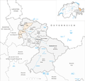
Division of the former Prättigau-Davos district into districts and municipalities
The Prättigau-Davos district has comprised the following districts and communities since its creation:
| circle | Municipal coat of arms | Name of the parish | Area in km² |
Remarks |
|---|---|---|---|---|
| District of Davos | Davos | 283.99 | 2009 expanded to include meadows . | |
| Jenaz district | Fideris | 25.36 | ||
| Furna | 33.32 | |||
| Jenaz | 25.91 | |||
| District of Klosters | Klosters-Serneus | 193.10 | ||
| Küblis district | Conters | 18.40 | ||
| Küblis | 8.14 | |||
| Saas | 26.71 | |||
| Luzein district | Asherina | 9.62 | Since 2007 at St. Antönien. | |
| Luzein | 31.60 | |||
| St. Antönien | 52.28 | Joined Luzein in 2016. | ||
| Schiers district | Grüsch | 43.30 | ||
| Schiers | 61.66 | |||
| Seewis district | Fanas | 21.84 | With Grüsch since 2011. | |
| Seewis | 49.63 | |||
| Valzeina | 11.44 | With Grüsch since 2011. |
Changes in the community

Municipalities until 2006

Municipalities until 2008
Municipalities until 2010

Municipalities until 2015


- 2007: Merger of St. Antönien and St. Antönien Ascharina → St. Antönien
- 2009: Merger of Davos and Wiesen → Davos
- 2011: Fusion of Grüsch , Fanas and Valzeina → Grüsch
- 2016: Fusion of Klosters-Serneus and Saas in the Prättigau → Klosters-Serneus
- 2016: Fusion of Luzein and St. Antönien → Luzein
Web links
- Editing: Prättigau / Davos. In: Historical Lexicon of Switzerland .
Albula |
Bernina |
Hinterrhein |
Imboden |
Inn |
Landquart |
Maloja |
Moesa |
Plessur |
Prättigau-Davos |
Surselva
Former districts of the canton of Graubünden until December 31, 2000:
Glenner |
Heinzenberg |
Oberlandquart |
Unterlandquart |
Val Müstair |
Vorderrhein
Canton of Graubünden | Districts of Switzerland | Municipalities of the Canton of Graubünden