Mustair
| Mustair | |
|---|---|
| State : |
|
| Canton : |
|
| Region : | Engiadina Bassa / Val Müstair |
| Political community : | Val Müstair |
| Postal code : | 7537 |
| former BFS no. : | 3843 |
| UN / LOCODE : | CH MSR |
| Coordinates : | 830 614 / 167250 |
| Height : | 1273 m above sea level M. |
| Area : | 77.74 km² |
| Residents: | 764 (December 31, 2007) |
| Population density : | 10 inhabitants per km² |
| Website: | www.cdvm.ch |
|
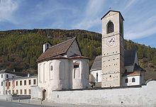
Müstair, on the right the Claustra San Jon |
|
| map | |

Müstair ( ; older German Münster, until 1943 officially Münster (GR) ) was until December 31, 2008 a political municipality in the Münstertal , which belongs to the Inn district of the Swiss canton of Graubünden .
On January 1, 2009, Müstair merged with the other Swiss municipalities in the valley ( Fuldera , Lü , Santa Maria Val Müstair , Tschierv and Valchava ) to form the municipality of Val Müstair .
Müstair is the easternmost place in Switzerland and is close to the Italian border. Beyond the border lies the South Tyrolean town of Taufers further down the valley . World famous is the Claustra San Jon , which the World Heritage Site of UNESCO belongs.
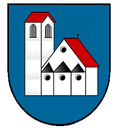
coat of arms
Blazon : In blue the monastery church of Müstair in silver with roofs in red, the seal motif of the community is reduced to the main element of the monastery.
population
| Population development | ||||||||||
|---|---|---|---|---|---|---|---|---|---|---|
| year | 1835 | 1850 | 1900 | 1950 | 2000 | 2007 | ||||
| Residents | 513 | 475 | 599 | 776 | 745 | 764 | ||||
The Romansh dialect Jauer is spoken in the village . In 1990 88% and in 2000 86% of the residents stated that they knew Romansh. In the years 1880 it was 87%, in 1910 88% and in 1941 89% as mother tongue . Since 1970, however, the German-speaking minority has been growing, while the number of Romansh speakers has stagnated. The following table shows the development over the past decades:
| Languages in Müstair | ||||||
| languages | 1980 census | 1990 census | 2000 census | |||
| number | proportion of | number | proportion of | number | proportion of | |
| Romansh | 574 | 81.19% | 578 | 76.86% | 543 | 72.89% |
| German | 123 | 17.40% | 160 | 21.28% | 184 | 24.70% |
| Italian | 8th | 1.13% | 10 | 1.33% | 4th | 0.54% |
| Residents | 707 | 100% | 752 | 100% | 745 | 100% |
Religions and denominations
In contrast to other communities in the valley, the local population remained Catholic . The place has been home to a Benedictine monastery since the 8th century . The parish church has been looked after by Capuchin fathers since 1696 .
nationality
Of the 805 villagers (as of the end of 2005), 759 (= 94%) were Swiss citizens.
history
The (former) community, which was settled early on, joined the Church of God in 1367 . In 1499 it was devastated by Austrian soldiers. After the sale by the Bishop of Chur, Müstair belonged to the Archduchy of Austria from 1728 to 1762 . From 1854 the village was a separate municipality.
To the east above the village are the ruins of the Balcun At castle .
mountains
The 2763 m high Piz Chavalatsch , on whose summit the Swiss-Italian border runs, marks the easternmost point of Switzerland.
Personalities
- Philipp Gallicius (1504–1566), born and raised in Puntweil near Müstair; Theologian, reformer and hymn poet
- Theodosius Florentini (1808–1865) Capuchin priest and social reformer
- Bonaventura Foffa (1828–1887), Abbot of Muri-Gries
- Friedrich Hoppe (1921–2008), honorary citizen of the community; Founder and President of Hoppe AG
Attractions
- St. Johann Benedictine Monastery , World Heritage Site
- Double chapel St. Ulrich and Nikolaus
- Holy Cross Chapel
- Monastery church
- Planta tower
- Chapel St. Sebastian, in the upper village
- Chasa Chalavaina (house from the 15th / 16th century, now a hotel)
literature
- Paul Eugen Grimm: Müstair (village). In: Historical Lexicon of Switzerland .
- Erwin Poeschel : The art monuments of the canton of Graubünden III. The valley communities Räzünser Boden, Domleschg, Heinzenberg, Oberhalbstein, Upper and Lower Engadine. (= Art Monuments of Switzerland. Volume 11). Edited by the Society for Swiss Art History GSK. Bern 1940. DNB 760079625 .
Web links
- Mustair Monastery
- Renzo Dionigi: Müstair Monastery: sculpture and frescoes
- Federal inventory ISOS: Müstair


