Taufers in the Münstertal
| Taufers in the Münstertal | |
|---|---|
| (Italian: Tubre ) | |
| coat of arms | map |
| State : | Italy |
| Region : | Trentino-South Tyrol |
| Province : | Bolzano - South Tyrol |
| District community : | Vinschgau |
|
Inhabitants : (VZ 2011 / 31.12.2019) |
965/958 |
|
Language groups : (according to 2011 census ) |
97.85% German 2.15% Italian 0.00% Ladin |
| Coordinates | 46 ° 39 ′ N , 10 ° 28 ′ E |
| Altitude : | 1,050– 3195 m slm (center: 1240 m slm ) |
| Surface: | 45.9 km² |
| Permanent settlement area: | 4.1 km² |
| Parliamentary groups : | Rifair |
| Neighboring municipalities: | Glurns , Val Müstair ( CH - GR ), Mals , Prad am Stilfserjoch , Stilfs |
| Postal code : | 39020 |
| Area code : | 0473 |
| ISTAT number: | 021103 |
| Tax number: | 00414320218 |
| Mayor (2015): | Roselinde Gunsch Koch ( SVP ) |
Taufers im Münstertal ( Italian Tubre , Rhaeto-Romanic ) with 958 inhabitants (as of December 31, 2019) is the westernmost municipality in South Tyrol in Italy and is located at 1250 m above sea level . The community is located in the lower Münstertal .
geography
location
The municipality of Taufers is located in the lower Münstertal , a side valley of the Vinschgau in the far west of South Tyrol, directly on the Italian-Swiss border with the canton of Graubünden . This is traversed here by the Rambach in a northeasterly direction. The mountains on the orographic left side of the valley belong to the Sesvenna group . The municipality reaches its highest point at the eponymous Piz Sesvenna ( 3204 m ). The Fallaschkamm , which delimits the Münstertal near Taufers on the orographic right side , is included in the Ortler Alps and is protected in the Stilfserjoch National Park .
Taufers borders the South Tyrolean communities of Mals , Glurns , Prad and Stilfs as well as the Graubünden communities Val Müstair and Scuol .
Settlement points
The settlement points of Taufers are between 1105 m (Unterrifair) and 1723 m (Egghof Tella) above sea level.
The main town of Taufers at an altitude of about 1250 m is a long street village and, although it only has about 700 inhabitants, is over 1.5 km long. In this part of the community are all public facilities, such as school, community office, doctor's clinic, parish church, almost all inns and shops. At the beginning of the main town there is also the St. John's Church , whose origins are said to go back to the 9th century.
Rifair ( Rhaeto-Romanic ) is divided into two hamlets: Unterrifair (Rifair) and Oberrifair (Schlossoir). While Unterrifair is again stretched out between the Rambach, the main body of water of the Munster valley and the foot of the mountain, Oberrifair is more like a clustered village.
Puntweil was originally a real clustered village, which has recently been torn up, at the same time its population has shrunk . The settlement on the border is a real new settlement, which serves almost exclusively for foreign trade and border operations. It was built after the First World War when administration buildings, a barracks and two guest houses were built there.
Tella is a group of farms in a south-facing position above the valley. The residents of the farms only farm there: Baustadelhof (1370 m), Schlosshof (1509 m), Kasparethof (1534 m - burned down in 1985), Bachhof (1558 m), Gandhof (1671 m), Egghof (1723 m) and Sommhof ( 1802 m - burned down in 1939). The castles Rotund , Reichenberg and Helfmirgott were built on this slope at the beginning of the Middle Ages .
The total area of the municipality on Italian territory is 4603 hectares. Of this, approx. 350 hectares are currently being intensified, i.e. H. used as fields or meadows. Furthermore, the municipality of Taufers still owns approx. 42.5 hectares of forest and pastureland on the other side of the state border in the neighboring municipality of Müstair in Switzerland.
Worth seeing
politics
mayor
Mayor since 1952:
- Alfons Dietl: 1952-1969
- Serafin Schgör: 1969–1980
- Rudolf Schütz: 1980–1985
- Heinrich Peer: 1985–1995
- Serafin Schgoer: 1995-2000
- Hermann Fliri: 2000–2015
- Roselinde Gunsch Koch: since 2015
coat of arms
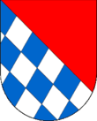
Shield divided diagonally to the right, red above, blue and silver diagonally roughened below. Coat of arms of the Lords of Reichenberg , who sat from the 12th century to 1373 on the castle of the same name above the village of Taufers as feudal bearers of the bishops of Chur. The sex died out at the beginning of the 15th century .
literature
- Municipality of Taufers iM (Ed.): Taufers im Münstertal through the ages . 2nd edition 2006, author: Dr. Serafin Heinrich Schgör
Web links
- Taufers municipality
- Landscape plan of the municipality of Taufers in Münstertal . Office for Landscape Ecology, Autonomous Province of Bolzano - South Tyrol (PDF file)
- Paul Eugen Grimm: Taufers. In: Historical Lexicon of Switzerland .
- Entry in the Tirol Atlas of the Institute for Geography at the University of Innsbruck
Individual evidence
- ↑ The mayors of the South Tyrolean municipalities since 1952. (PDF; 15 MB) In: Festschrift 50 Years of the South Tyrolean Association of Municipalities 1954–2004. Association of South Tyrolean municipalities, pp. 139–159 , accessed on November 16, 2015 .


