
Kaltern
| Kaltern on the wine route | |
|---|---|
| (Italian: Caldaro sulla strada del vino ) | |
coat of arms
 |
map  |
| State : | Italy |
| Region : | Trentino-South Tyrol |
| Province : | Bolzano - South Tyrol |
| District community : | Überetsch-Unterland |
|
Inhabitants : (VZ 2011 / 31.12.2019) |
7,664 / 8,085 |
|
Language groups : (according to 2011 census ) |
92.61% German 7.03% Italian 0.36% Ladin |
| Coordinates | 46 ° 25 ′ N , 11 ° 15 ′ E |
| Altitude : | 212– 1856 m slm (center: 425 m slm ) |
| Surface: | 47.96 km² |
| Permanent settlement area: | 20.0 km² |
| Parliamentary groups : | Altenburg , Dorf, Mitterdorf , Oberplanitzing, St. Anton / Pfuß , St. Josef am See, St. Nikolaus , Unterplanitzing |
| Neighboring municipalities: | Amblar-Don , Cavareno , Eppan , Neumarkt , Pfatten , Ruffrè-Mendola , Sarnonico , Tramin |
| Partnership with : | Heppenheim , Tegernsee |
| Postal code : | 39052 |
| Area code : | 0471 |
| ISTAT number: | 021015 |
| Tax number: | 80006090213 |
| Mayor (2015): | Gertrud Benin Bernard ( SVP ) |
Kaltern an der Weinstrasse ([ ˈkaltɐn ]; Italian Caldaro sulla Strada del Vino ) is an Italian municipality in South Tyrol with 8085 inhabitants (as of December 31, 2019). Kaltern is located in the Überetsch on the South Tyrolean Wine Road between Eppan and Tramin .
geography

The municipality of Kaltern is located in the south of South Tyrol a few kilometers southwest of the provincial capital Bozen . The total area of 47.96 km² includes the southern half of the Überetsch - a hilly landscape raised orographically to the right above the valley floor of the Adige , in which the settlement centers of the municipality are located - as well as a section of the Mendelkamm rising to the west and small parts of the lowlands .
The community center of Kalterns spreads out at the foot of the Überetscher slope of the Mendelkamm. The formerly separate old town centers of Kaltern ( village ), Mitterdorf and St. Anton / Pfuss and St. Nikolaus, which are a little higher up, have almost grown together in the course of the 20th century (from around 400 to 600 m slm ). In the west, the settlement areas are dominated by the Mendelkamm, which stretches from north to south and bears the border with Trentino . The ridge is cut by the Mendel Pass ( 1363 m ) high above St. Anton, a summit dominating the village is found in Penegal ( 1737 m ) a little north of the pass. In the east on the municipal boundary to Pfatten is the u. a. Mitterberg mountain range divided by the spring valley, which separates the Überetsch from the bottom of the Etsch valley.
In the north, Caldaro meets the neighboring municipality of Eppan , beyond the two fractions of Oberplanitzing ( 500 m ) and Unterplanitzing ( 430 m ) . To the south of the main town, the terrain descends gently to Lake Kaltern ( 215 m ) with the St. Josef am See district . Farther south, the municipality protrudes a little into the flat valley floor of the lowlands, where Kaltern borders on Tramin and Neumarkt . In the southwest of the municipality - on a low mountain plateau high above Lake Caldaro - there is finally Altenburg ( 610 m ).
history
Stone chamber graves from the Stone Age were found in the Klavenz district of Kaltern . The first traces of settlement in the area around Kaltern date from the early and middle Bronze Age between 1,700 and 1,300 BC and were found on the hills of the Leuchtenburg and Laimburg .
The place name is first attested in the so-called Vigilius letter from the 11th century as Caldare , 1184 as Caltarn and 1519 as Kaltern and Kalthern ; Etymologically it probably comes from the Latin caldaria (boiler). 1439 is a separate right to borrow from Caldaro and Tramin as "usus et consuetudo terre Caldary et cappelle Trameni" ( legal customs of the Kaltern-Traminer area) attested. From the administrative point of view, Kaltern was the focus of its own regional court from the 13th century, which was alienated from the bishopric of Trento under the rule of the Counts of Tyrol and first to the Lords of Rottenburg , then after their disempowerment in the early 15th century was permanently assigned to royal officials.
Numerous representative buildings from the 16th and 17th centuries are determined by the so-called Überetscher style , a hybrid late Renaissance style . Already the description of the country by Marx Parakeet von Wolkenstein from the Teit around 1600 reports that Kaltern, in contrast to the rural surroundings, shows "stattheuser" . In 1657 Kaltern was raised to a market town .
Attractions
- South Tyrolean Wine Museum , dedicated to the "Kalterer" (wine) and the wine route
- Parish Church of the Assumption of Mary
- St. Vigil and St. Peter in Altenburg
- Mendelbahn
- Sallegg Castle in Mitterdorf
- Church of St. Nicholas
- Kaltern outdoor pool: technically complex, formally ambitious architecture, built in 2006 by the Viennese architecture firm "the next ENTERprise" (Marie-Therese Harnoncourt and Ernst Fuchs)
- Le Carceri prison gallery
economy
Tourism and agriculture, especially fruit and wine growing , are the most important economic factors.
education
In Kaltern there are three primary schools in the center, in Oberplanitzing and in St. Josef, as well as a middle school . The four institutions together form a common German-speaking school district .
freetime and sports
Hiking trails
Kaltern and the surrounding area have numerous well-marked hiking routes:
- Circular route around Lake Caldaro: easily accessible panoramic route, leads through the largest preserved wetland between the Po Valley and the Alps
- Ascent to Altenburg: ( 615 m slm ), from St. Josef ( 228 m slm ), two route variants: No. 14 via St. Peter or No. 1 through the Rastenbachklamm, return via the "Friedensweg"
- Big and Small Montiggler Lake : from the north shore of Lake Kaltern or from Kaltern, paths no.19 and 20
- Kalterer Höhenweg: from Altenburg to Göllerwiese (1510 m), from there either descent to Söll near Tramin and the Seerundweg or to Roen (2116 m) and the Überetscher hut
- Steeper hikes on the Mendel (Roen 2116 m, Penegal 1740 m)
- Route of the former Überetscher Bahn (bike and hiking trail to Bolzano)
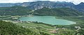
Lake Kaltern
The water temperature of Lake Kaltern is up to 28 degrees in summer (considered the warmest bathing lake in the Alps), so the bathing season usually begins in mid-May. The lake is also suitable for rowing and pedal boats, for sailing and windsurfing and in winter for ice skating. In addition to the outdoor swimming pool, which was newly built in 2006, there is also a beach volleyball court .

politics
mayor
Mayor since 1952:
- Anton Gratl: 1952–1956
- Siegfried Sölva: 1956–1965
- Arthur Atz: 1965-1969
- Robert Morandell: 1969-1970
- Hermann Sölva: 1970–1980
- Wilfried Battisti Matscher: 1980-2010
- Gertrud Benin Bernard: since 2010
Community partnerships
Kaltern maintains a partnership with
- the German district town of Heppenheim in the Bergstrasse district ( Hesse )
- the Upper Bavarian city of Tegernsee
Personalities
Sons and daughters
- Matthias Alban (1634–1712), violin and lute maker
- Anton Sepp (1655–1733), missionary of the Jesuit order
- Josef Valentin von Morandell (1770–1843), colleague of Andreas Hofer's
- Maria von Mörl (1812–1868), mystic
- Karl Atz (1832–1913), art historian
- Maria Anna von Buol-Berenberg (1861–1943), folk writer
- Petrus Klotz (1878–1967), Archabbot in Salzburg, travel writer
- Nikolaus von Lutterotti (1892–1955) Benedictine, prior and archivist of the Benedictine Abbey of Grüssau in Lower Silesia
- Fritz Ranzi (1909–1977), historian
- Hans Psenner (1912-1995), zoologist
People with a relationship with Kaltern
- Franz Six (1909–1975), German SS brigade leader and Nazi functionary; spent his old age in Kaltern
- Kurt Brand (1917–1991), German science fiction author; lived and spent his old age in Kaltern
- Sabina Florian (* 1983), Italian ice hockey player
- Andreas Seppi (* 1984), Italian tennis player; lives in Kaltern
- Anton Bernard (* 1989), ice hockey player for the Italian national team
- Andreas Bernard (* 1990), Italian national ice hockey goalkeeper, goalkeeper in the 1st Finnish league (Liiga)
- Raphael Andergassen (* 1993), ice hockey player for the Italian national team
- Lisa Fissneider (* 1994), Italian swimmer; lives in Kaltern
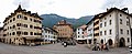
Panorama market square Kaltern

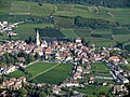
Kaltern, village

Kaltern, village
Caldaro, of Altenburg from

Mendelbahn valley station
View of Kaltern from the Mendel Pass


literature
- Leo Andergassen (ed.): Church in Kaltern - history, cult and art. In memory of the construction of the parish church 200 years ago. Parish Caldaro 1992.
- Arnold Dissertori: Kaltern am See . Athesia, Bozen 1989 ( online )
- Hubert Felderer: Houses in Kaltern: a contribution to the history of houses in the market town of Kaltern with a focus on the second half of the 18th century . In: Der Schlern , 2007, pp. 74–97.
- Franz-Heinz Hye : The market town of Kaltern: Aspects of its older history. In: Der Schlern 81, 2007, pp. 4–15.
- Anton Maurer: Churches in Kaltern . Schnell & Steiner, Munich 1978.
Web links
- Official website of the municipality of Kaltern
- Landscape plan of the municipality of Kaltern . Office for Landscape Ecology, Autonomous Province of Bolzano - South Tyrol (PDF file)
- Entry in the Tirol Atlas of the Institute for Geography at the University of Innsbruck
Individual evidence
- ↑ The history of Kaltern Kaltern-am-see.info, accessed on February 17, 2020
- ^ Egon Kühebacher : The place names of South Tyrol and their history . Volume 1. Bozen: Athesia 1995. ISBN 88-7014-634-0 , pp. 177f.
- ^ Hannes Obermair : Bozen Süd - Bolzano Nord. Written form and documentary tradition of the city of Bozen up to 1500 . tape 2 . City of Bozen, Bozen 2008, ISBN 978-88-901870-1-8 , p. 88-89, no. 1008 .
- ↑ Otto Stolz : Political-historical description of the country of South Tyrol. Volume 2: Quarter on the Adige . Innsbruck: Wagner 1938, p. 190ff.
- ↑ Description of the region of South Tyrol: written around 1600, first edited from the manuscripts by a study group of Innsbruck historians. Ceremony for Hermann Wopfner's sixtieth year of life, May 21, 1876. (Schlern-Schriften 34). Innsbruck: Wagner 1936, p. 212.
- ↑ School district Kaltern. South Tyrolean Citizens' Network , accessed on October 25, 2014 .
- ↑ The mayors of the South Tyrolean municipalities since 1952. (PDF; 15 MB) In: Festschrift 50 Years of the South Tyrolean Association of Municipalities 1954–2004. Association of South Tyrolean municipalities, pp. 139–159 , accessed on November 16, 2015 .
- ↑ life data

Abbey | Ahrntal | Aldein | Algund | Altrei | Andrian | Auer | Barbian | Bolzano | Branzoll | Burner | Brixen | Brunico | Burgstall | Corvara | Nova Ponente | Enneberg | Eppan | Feldthurns | Franzensfeste | Freienfeld | Gais | Gargazon | Glurns | Graun im Vinschgau | Casies | Avelengo | Innichen | Jenesien | Kaltern | Karneid | Kastelbell-Tschars | Castelrotto | Kiens | Klausen | Kuens | Kurtatsch | Kurtinig | Lasa | Laion | Lana | Laces | Laurein | Laives | Lüsen | Times | Margreid | Marling | Martell | Merano | Mölten | Montan | Moos in Passeier | Mühlbach | Mühlwald | Nals | Naturno | Naz-Sciaves | Neumarkt | Niederdorf | Olang | Partschins | Percha | Falzes | Pfatten | Pfitsch | Plausibility | Prad | Braies | Prettau | Proveis | Lawn Antholz | Ratschings | Riffian | Ritten | Rodeneck | Salurn | Sand in Taufers | Sarntal | Schenna | Schlanders | Schluderns | Schnals | Sexten | St. Christina in Val Gardena | St. Leonhard in Passeier | St. Lorenzen | St. Martin in Passeier | St. Martin in Thurn | St. Pankraz | Ortisei in Val Gardena | Sterzing | Stilfs | Taufers im Münstertal | Terenten | Terlan | Tiers | Tyrol | Tesimo | Toblach | Tramin | Truden | Tscherms | Ulten | Our Lady in the Walde-St. Felix | Vahrn | Villandro | Villnöß | Vintl | Fiè allo Sciliar | Verano | Waidbruck | Monguelfo Tesido | Welschnofen | Wengen | Selva in Val Gardena