Mendel ridge
| Mendel ridge | |
|---|---|
|
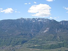
The (snowless) northern part of the Mendelkamm from the southeast: the ridge depression a little to the left of the center is the Mendelpass, the mountain in the center of the picture is the Penegal, to the right the Gantkofel; in the background the snow-capped peaks of the Ortler and Ötztal Alps. |
|
| Highest peak | Roen ( 2116 m slm ) |
| location | Nonsberg Group , Southern Alps ; South Tyrol / Trentino ( Italy ) |
| Coordinates | 46 ° 22 ' N , 11 ° 12' E |
The Mendelkamm , also known as the Mendelgebirge , is an approximately 35 km long mountain group in South Tyrol and Trentino . The Mendelkamm is included in the Nonsberg Group and thus in the Southern Limestone Alps .
location
The Mendelkamm separates the Non Valley in the west and the Adige Valley in the east on the length between the Gampenpass and the Rotaliana plain . For most of the route, the border between Trentino and South Tyrol runs over the summit ridge, only the northernmost section on the Deutschnonsberg is entirely in South Tyrol and the southernmost section from the height of the Salurner Klause in Trentino.
topography
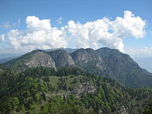
The Mendelkamm is characterized by the relatively small height differences on its summit ridge. Only once does it fall well below an altitude of 1500 m on the Mendel Pass , only once does it exceed a height of 2000 m on the Roen . The asymmetry of the mountain ridge in the longitudinal profile is also noticeable : While the Non Valley in the west rises largely only with slight gradients to the peaks, which, viewed from there, often appear as less prominent hilltops, the mountain group breaks off very steeply to the east into the Adige Valley.
The Mendelkamm runs from the Gampenpass ( 1518 m slm ) south of Merano , which separates the ridge from the Laugen and connects the Etschtal with the Deutschnonsberg , initially in a slight curve to the southeast over the first little elevations, including Schönegg ( 1772 m ) and Hochkührast ( 1836 m ), to the Gantkofel ( 1866 m ). On the Gantkofel, which towers over the Bozen valley basin in the east with its large rock face , the Mendelkamm turns south. From here it forms the border between South Tyrol and Trentino and towers over a distance of about 14 km in the east over the landscape called Überetsch , which is separated by the parallel Mitterberg to the valley floor of the Adige . The next summit is the Penegal ( 1737 m ), before the ridge drops to the Mendel Pass ( 1363 m ). This is accessible by the SS 42 and the Mendelbahn .
South of the Mendel Pass, the terrain climbs over various intermediate peaks to the highest mountain on the Mendel ridge, the Roen ( 2116 m ). On the Roen, on the east side of which the Überetsch merges into the Unterland , there is also the only refuge in the mountain range, the Überetscher Hütte ( 1775 m ). Towards the south, the terrain drops again rapidly to the Grauner Joch ( 1800 m ) and subsequently only reaches heights between 1600 m and 1700 m with several elevations . On the west side of this area lies the plateau called Altopiano della Predaia . The first summit, which again reaches over 1800 m , but is otherwise only slightly prominent in the ridge, is the Tresner Horn ( 1812 m ). Here the Mendelkamm turns in a south-westerly direction and is located just behind the Fenner Joch ( 1563 m ), which is in front of the Fennberg ( 1468 m ) and the Salurner Klause to the south-east , and the Cimoni ( 1729 m ) only in Trentino.
On the last section, the Mendelkamm reaches again significant heights at the Wiggerspitze ( Cima Roccapiana , 1873 m ) and at the Cima Monticello ( 1857 m ). It finally falls over the extensive terrace of Monte Mezzocorona into the Rotaliana plain near Mezzocorona , where the Non Valley joins the Adige Valley.
Viticulture
Not only in Tramin and Kaltern , but also as far north as Eppan , viticulture finds ideal growth conditions thanks to the special, loose limestone and the associated gravel soils . The south to south-east slopes are suitable for strong and fruity grape varieties from Gewürztraminer to Pinot Blanc or Sauvignon. The mild climate of the Überetsch and the eastern Mendel slopes above is characterized, among other things, by frequent downward winds , the warming of which (by around 6 ° per 1,000 meters of altitude) creates a well-ventilated microclimate .
Flora
On the western and eastern slopes of the Mendel Mountains there are partly extensive forests with European beech and Scots pine . At over 1000 m above sea level, there are spruce forests and, above all, larch meadows on the Nonstal side. The laying pine also occurs in some places. The flora is similar to that of the Dolomites, but there are no high mountain plants because the peaks are not so high.
origin of the name
The word Mendel appears in a document from the beginning of the 15th century ( Otto Stolz : The expansion of Germanness in South Tyrol in the light of the documents ).
There is no definite explanation of the etymology. Egon Kühebacher believes a relationship with a Romanesque menda is possible, which in Sardinian means "uncultivated land that serves as pasture". If there is a connection with Old High German mendi ("joy, delight"), the name could refer to the good pasture land, the fertile hunting grounds, but also to the summer freshness, which is preferred to the heat in the valley floor; Many residents of the eastern Mendel slopes have always spent the summer there in the mountains. Possibly it is also a pre-Indo-European relic word that finds a parallel in Basque mendi with the meaning "mountain".
Web links
Individual evidence
- ↑ Johannes Ortner: Messila and Mëisules . In: Experience the mountains - The magazine of the Alpine Association of South Tyrol . No. 1 , 2017, p. 58-59 .


