Fennberg
| Fennberg | ||
|---|---|---|
|
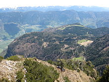
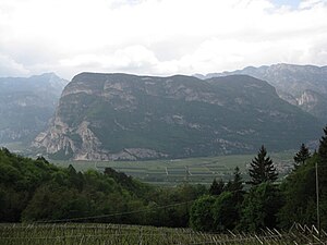
The Fennberg from the southeast, Buchholz seen from |
||
| height | 1468 m slm on the Rappenkoflwand | |
| location | South Tyrol / Trentino , Italy | |
| Mountains | Mendelkamm , Nonsberg Group | |
| Coordinates | 46 ° 16 '37 " N , 11 ° 9' 45" E | |
|
|
||

The Fennberg ( Italian Favogna ) is a plateau mountain that rises approx. 1000 m above the South Tyrolean Unterland ( Italy ).
Location and surroundings
The Fennberg is located in the extreme south of the Unterland in South Tyrol and is in front of the Mendelkamm to the east. Together with the vulture opposite , it forms the section of the Adige Valley called Salurner Klause , on which the German-Italian language border runs alongside the South Tyrolean border.
While the plateau on the Fennberg lies entirely in South Tyrol in the area of the municipalities of Margreid and Kurtatsch , the south-sloping flank belongs to Roverè della Luna in Trentino .
topography
The Fennberg breaks off steeply in the east and south into the Etsch valley, in the north into the Fenner Gorge called the valley of the Fenner Bach and in the west into the Höllental. Only in the northwest is it connected to the Mendelkamm, which descends here to the Fenner Joch ( 1563 m ), a transition to the Non Valley between Tresner Horn ( 1811 m ) and Cimoni ( 1729 m ).
The plateau of the Fennberg, which is characterized by forests and meadows, is divided into two halves by a terrain level running roughly in an east-west direction. To the north of this terrain is the Oberfennberg with an extensive moor and its village belonging to Kurtatsch. This is located at an altitude of about 1100 m to 1200 m and has the Ulmburg residence, which is also a late Renaissance building. In the west, the Oberfennberg reaches its highest point on the Rappenkoflwand at 1468 m . It is mainly drained by the Fenner Bach, whose gorge separates the Fennberg from the Fennhalser Plateau to the north . The Unterfennberg is located in the municipality of Margreid. The village here and the nearby Fennberger See , from which the Krebusbach flows into the Höllental, are at just over 1000 m above sea level. At its southern end over the demolition to Roverè della Luna, it climbs to 1167 m on Giggereck .
reachability

A road approved for public traffic leads from Kurtatsch below the Mendelkamm, first to Ober- and then on to Unterfennberg. The Unterfennberg can be reached via hiking trails from Roverè della Luna through Höllental from the west and up from Margreid to the northeast. A via ferrata leads through the steep southeast flank of the Fennberg, the approach of which is on the road from Margreid to Salurn . The Oberfennberg is connected to the Non Valley by a hiking trail over the Fenner Joch.
Surname

The Fennberg is first documented in the founding records of the nearby Augustinian canons of St. Michael an der Etsch in 1144/45 as Mons Faone . The name probably goes back to a combination of the Latin fagus with the suffix -onia and means something like beech forest .
literature
- Heinz Tiefenbrunner: Fennberg . Athesia, Bozen 1994, ISBN 88-7014-800-9
Web links
Individual evidence
- ↑ Hannes Obermair , Martin Bitschnau : Le 'notitiae traditionum' del monastero dei canonici agostiniani di S. Michele all'Adige. Studio preliminare all'edizione della Sezione II del Tyrolean document book . In: Studi di storia medioevale e di diplomatica . XVIII (2000), pp. 97-171.
- ^ Egon Kühebacher : The place names of South Tyrol and their history. The historically grown names of the communities, parliamentary groups and hamlets. Athesia, Bozen 1991. ISBN 88-7014-634-0 , p. 282.

