Wigger tip
| Wigger tip | ||
|---|---|---|
|
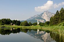
The Wiggerspitze seen from the north from the notch between Wiggerspitze and Monte Cucco |
||
| height | 1873 m slm | |
| location | Trentino , Italy | |
| Mountains | Alps , Nonsberg Group , Mendelkamm | |
| Dominance | 10.5 km → Roen | |
| Notch height | 370 m | |
| Coordinates | 46 ° 15 '36 " N , 11 ° 8' 2" E | |
|
|
||
| rock | Main dolomite | |
The Wiggerspitze ( Italian Cima Roccapiana ) is a 1873 m slm high mountain in the southern half of the Mendelkamm , which is part of the Nonsberg group in the Alps .
Location and surroundings
The Wiggerspitze is the highest point in the southern Mendelkamm. It is located just south of the South Tyrolean border in Trentino . At the summit, the borders of the municipalities of Roverè della Luna and Mezzocorona in the Adige Valley and the municipality of Ton in the Non Valley meet.
Climbs

The summit of the Wiggerspitze can be reached via marked hiking trails. From the Fennberger Plateau in South Tyrol , whose view dominates the Wiggerspitze, and from Roverè della Luna, the shortest ascent is via the Malga Kraun and the southeast flank. Two more trails reach the summit cross from the southwestern Cima Monticello ( 1857 m ) and from the north.
Web links
- Description of crossing the Cima Roccapiana on hikr.org

