Gantkofel (Mendelkamm)
| Gantkofel / Monte Macaion | ||
|---|---|---|
|
The Gantkofel over the Adige Valley (from the northeast) |
||
| height | 1866 m slm | |
| location | South Tyrol / Trentino , Italy | |
| Mountains | Nonsberg group | |
| Dominance | 8.9 km → Laugenspitze | |
| Notch height | 348 m ↓ Gampenpass | |
| Coordinates | 46 ° 29 '42 " N , 11 ° 12' 33" E | |
|
|
||
| rock | lime | |
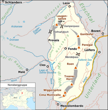
The Gantkofel ( 1866 m slm , Italian Monte Macaion ) is the northeast corner pillar of the Mendelkamm , a 35 km long mountain range between the Adige Valley and the Non Valley on the border between South Tyrol and Trentino . The Gantkofel rises to the west over the Bozen valley basin and the Überetsch .
The summit carries some radio transmitters. With the distinctive shape of its steep rock face sloping to the east, it shapes the valley panorama along the Adige in the area of Merano , Bolzano and Eppan .
location
Location of the Gantkofel in the Nonsberg group (left)
and in the Alps (right).
Surname
The word Gånd is probably a pre-Indo-European relic word that has been preserved in the South Tyrolean dialect with the meaning “scree slope, pile of stones” and thus probably refers to the large landslide area of the Gantkofel towards the Adige Valley. Kofel is in the meaning of "mountain peak, rock formation" a frequently used part of the name of mountains. The Italian name Macaion comes from Nonsbergerisch * mac , which means something like "blunt" and thus describes the flat summit corridor of the Gantkofel quite well.
Web links
- Hiking report Perdoning - Gantkofel Description of the hike with a 360 ° spherical panorama photo of the Gantkofel
Individual evidence
- ↑ Johannes Ortner: Disagreement and other errors . In: Experience the mountains - The magazine of the Alpine Association of South Tyrol . No. 5 , 2019, p. 60-61 .


