
Fondo
| Fondo | |||
|---|---|---|---|

|
|||
| Country | Italy | ||
| region | Trentino-South Tyrol | ||
| province | Trento (TN) | ||
| local community | Borgo d'Anaunia | ||
| Coordinates | 46 ° 26 ' N , 11 ° 8' E | ||
| height | 982 m slm | ||
| surface | 30.63 km² | ||
| Residents | 1,446 (December 31, 2018) | ||
| Population density | 47 inhabitants / km² | ||
| patron | San Martino | ||
| Church day | November 11th | ||
| Telephone code | 0463 | CAP | 38013 |
Fondo ( German obsolete pound ) is a fraction and municipality seat of the Italian municipality ( comune ) Borgo d'Anaunia in the province of Trento , region of Trentino-South Tyrol .
geography
The place is located about 41 kilometers north of Trento in the upper Non Valley (Italian Val di Non ). To the north of Fondo, part of the valley is German-speaking ( Deutschnonsberg ) and belongs to South Tyrol (Autonomous Province of Bozen). Between Fondo and Castelfondo to the west is the valley of the Rio Novella coming from Our Lady in the Forest and St. Felix , which rises at the Gampenpass ( 1518 m slm ). The Roggia di Fondo flows through the village.
Touristy the area is of Fondo a starting point for climbing the Mendelkamm ( Gantkofel 1866 m slm , Penegal 1743 m slm ) and the Brenta , but also located in the western Ortler .
history
Fondo was an independent municipality until 2019 and merged with the neighboring municipalities of Castelfondo and Malosco on January 1, 2020 to form the new municipality of Borgo d'Anaunia.
traffic
With Alto Fondo is through the Strada Statale 238 delle Palade connected, via the Gampenpass according Meran leads. Until 1934 the place was by the local railway Dermulo Mendel both the Mendelbahn and with Trent on the Nonstalbahn developed.

San Martino Church

Piazza San Giovanni
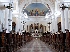
San Martino Church: interior
_01.jpg)

_02.jpg)
Web links
Individual evidence
- ↑ Official Journal of the Autonomous Region Trentino – Alto Adige / South Tyrol No. 46 November 15, 2019 Special issue 1. In: regione.taa.it. Retrieved January 3, 2020 .