Laurein
| Laurein | |
|---|---|
| (Italian: Lauregno ) | |
| coat of arms | map |
| State : | Italy |
| Region : | Trentino-South Tyrol |
| Province : | Bolzano - South Tyrol |
| District community : | Burgrave Office |
|
Inhabitants : (VZ 2011 / 31.12.2019) |
345/338 |
|
Language groups : (according to 2011 census ) |
96.71% German 3.29% Italian 0.00% Ladin |
| Coordinates | 46 ° 27 ' N , 11 ° 4' O |
| Altitude : | 1150 m slm |
| Surface: | 14.2 km² |
| Permanent settlement area: | 1.8 km² |
| Parliamentary groups : | Tonna |
| Neighboring municipalities: | Brez (TN), Borgo d'Anaunia (TN), Novella (TN), Proveis (BZ), St. Pankraz (BZ), Ulten (BZ) |
| Postal code : | 39040 |
| Area code : | 0463 |
| ISTAT number: | 021043 |
| Tax number: | |
| Mayor (2015): | Hartmann Thaler ( SVP ) |
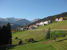
Laurein ([ laʊ̯ˈraɪ̯n ]; Italian : Lauregno ) is an Italian municipality with 338 inhabitants (as of December 31, 2019) in South Tyrol on the Deutschnonsberg about 20 kilometers west of Bolzano and about 45 kilometers north of Trento . It is one of three German-speaking communities in the Non Valley .
geography
The municipality of Laurein is located in the upper Non Valley , more precisely on the Deutschnonsberg , as the German-speaking area of the valley is called. Together with the neighboring municipality of Proveis , Laurein protrudes as a South Tyrolean spur into the otherwise Italian- speaking Val di Non, which largely belongs to the Trentino . The small village center is in the south of the municipality at an altitude of 1150 m . To the north of it, Laurein advances with a narrow strip of territory towards Hofmahdjoch , which provides a 1781 m high transition into Ultental . On the west side of it, the municipal area of the Kleinen ( 2311 m ) and Grosse Kornigl ( 2418 m ) reaches the summit points of the Ilmenkamm of the Ortler Alps .
coat of arms
Description of the coat of arms : in blue a black plow on a gold helmet cushion with clover corners .
history
Laurein is mentioned for the first time in 1233 as " terra Lauregni ", while at the same time there is talk of Laurein's own loan right (" consuetudo locationum mansorum ") as a reference to the settlement of the area that took place in the 13th century and probably originated from Ulten . Linguistically, the name is traced back to Rhaetian Lawara with the suffix -onia , which means something like "stony terrain". On the other hand, an alleged first mention of the Laureinerberg in an edict of the Ostrogoth king Theodoric the Great from 505 is considered a modern forgery in the scholarly interest .
Laurein belonged to the County of Tyrol and thus to Austria-Hungary until the end of the First World War . With the Treaty of Saint-Germain in 1920, the village came to Italy together with most of Tyrol south of the main Alpine ridge . When the two provinces of Bolzano and Trento emerged in these formerly Austrian areas in 1927, Laurein, like the other municipalities of Deutschnonsberg, was added to the predominantly Italian-speaking province of Trento. It was not until 1948 that Laurein was incorporated into the province of Bozen or South Tyrol.
Until 1998, when a tunnel under the Hofmahdjoch in the Val d'Ultimo was opened, and Laurein Proveis from the rest of South Tyrol were off the road just about Trentino accessible territory.
Population development

Culture and sights
politics
Mayor since 1952:
- Alois Kollmann: 1952–1980
- Ignaz Kerschbamer: 1980–1990
- Oswald Ungerer: 1990-2010
- Hartmann Thaler: since 2010
literature
- Hubert Ungerer: Laurein on Deutschnonsberg . Edited by the Regional Association for Home Care in South Tyrol, 1983 (online) .
- Cristian Kollmann: Grammar of the dialect of Laurein: a theory of sounds and forms from a synchronous, diachronic and contrastive point of view (Journal of Dialectology and Linguistics 147). Stuttgart: Steiner 2012. ISBN 978-3-515-09944-8 .
Web links
- Laurein parish
- Landscape plan of the municipality of Laurein . Office for Landscape Ecology, Autonomous Province of Bolzano - South Tyrol (PDF file)
- Entry in the Tirol Atlas of the Institute for Geography at the University of Innsbruck
Individual evidence
- ^ Hannes Obermair : Nonsberger Regesten. The Unterweg-Perger archive in Proveis In: « Der Schlern ». 66 . 1992. Issue 9, pp. 587-600, reference p. 587.
- ^ Egon Kühebacher : The place names of South Tyrol and their history . Vol. 1, Bozen 1995. ISBN 88-7014-634-0 . P. 216.
- ^ Richard Heuberger : An alleged edict of Theodoric the Great from the year 505 from the Castrum Maiense on the Laureinerberg. In: Festschrift Karl Pivec (Innsbruck Contributions to Cultural Studies 12). Edited by Anton Haidacher and Hans Eberhard Mayer. Innsbruck 1966, pp. 201-203.
- ↑ The mayors of the South Tyrolean municipalities since 1952. (PDF; 15 MB) In: Festschrift 50 Years of the South Tyrolean Association of Municipalities 1954–2004. Association of South Tyrolean municipalities, pp. 139–159 , accessed on November 16, 2015 .


