Rasen Antholz
| Rasen Antholz | |
|---|---|
| (Italian: Rasun Anterselva ) | |
| coat of arms | map |
| State : | Italy |
| Region : | Trentino-South Tyrol |
| Province : | Bolzano - South Tyrol |
| District community : | Val Pusteria |
|
Inhabitants : (VZ 2011 / 31.12.2019) |
2,870 / 2,911 |
|
Language groups : (according to 2011 census ) |
98.40% German 1.16% Italian 0.44% Ladin |
| Coordinates | 46 ° 51 ′ N , 12 ° 6 ′ E |
| Altitude : | 926– 3436 m slm (center: 1030 m slm ) |
| Surface: | 120.92 km² |
| Permanent settlement area: | 13.6 km² |
| Parliamentary groups : | Antholz Mittertal , Antholz Niedertal , Antholz Obertal , Neunhäusern , Niederrasen , Oberrasen |
| Neighboring municipalities: | Bruneck , Gsies , Olang , Percha , Sand in Taufers , St. Jakob in Defereggen , Welsberg-Taisten |
| Postal code : | 39030 |
| Area code : | 0474 |
| ISTAT number: | 021071 |
| Tax number: | 00409320215 |
| Mayor (2015): | Thomas Schuster ( SVP ) |
Rasen-Antholz ([ ˈraːsn̩-ˈanthɔlts ]; Italian Rasun Anterselva ) is an Italian municipality in South Tyrol with 2911 inhabitants (as of December 31, 2019). It includes the Antholz Valley (a side valley of the Puster Valley) and a smaller area of the Puster Valley . The community is particularly known for its cross-country skiing and biathlon infrastructure.
geography

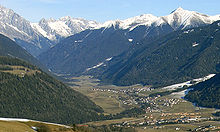
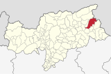
Rasen-Antholz is located in the east of South Tyrol, east of Bruneck . The community area of 120.92 km² takes up the entire Antholz Valley . In addition, it also includes smaller areas of the Puster Valley , which runs in an east-west direction , from which the Antholz Valley branches off in a northerly direction near the Olang Basin. The population settles in six larger village settlements with parliamentary group status as well as a few hamlets and individual farms.
At the entrance of the Antholz Valley, from Antholz stream flowing through it, are located in close succession, first Niederrasen (1010 1050 m slm ), the capital of the municipality, and then Oberrasen (1080- 1110 m ). Significantly further into the valley are Anterselva (1110- 1140 m ), Antholz Mittertal (1240- 1270 m ) and - for a pivot of the valley to the northeast - the scattered settlement Anterselva di Sopra (about 1300 m ). At the end of the valley is the Antholz lake ( 1642 m ), before the terrain rises sharply to the Staller Sattel ( 2052 m ), a passable pass over the Italian-Austrian border into the state of Tyrol or into the East Tyrolean Defereggental .
The Staller Sattel also establishes the connection between the two mountain groups that frame Antholz, the Rieserferner group and the Villgraten mountains . The mountain ridge that borders the valley in the west and north and is largely protected in the Rieserferner-Ahrn Nature Park belongs to the Rieserferner group. The most important peaks rising high above the valley floor include the Gelttalspitze ( 3126 m ), the Fernerköpfl ( 3248 m ), the Magerstein ( 3273 m ), the Wildgall ( 3273 m ) and the Hochgall ( 3436 m ), all of which are Antholz screen from the northern Reintal , as well as the Große Ohrenspitze ( 3101 m ). The ridge of the Villgraten Mountains, which builds up on the east side of the Antholz Valley, has no three-thousand-meter peaks. Its highest peak is the Rote Wand ( 2818 m ). Since the borderline deviates from the watershed over a short distance, the uppermost section of the Karbachtal , which flows into the eastern Gsieser Tal , also belongs to the municipality.
The belonging to Anterselva portion of the Pustertal limited in the pelvic area, in which the southern neighbor municipality to Olang expands to the commercial area and the district Neunhäusern (1000- 1010 m ). To the west of it the municipal area bulges out somewhat, includes a few houses from Nasen on the border with Percha and even crosses the Rienza , which means that a small area at the foot of the Plan de Corones is also part of Rasen-Antholz.
history
At the entrance to the Antholz Valley, in the corridor of the same name, there is the Windschnur burial ground from the Hallstatt period with numerous interesting finds. The sensational Rieserferner find also dates from the same time .
The valley name Antholz was first mentioned in the years 1050-1065 as "Êntholz" in the tradition book of the Brixen monastery . There are several hypotheses about the etymological provenance of the word. Beda Weber wrote in 1838:
“The name Antholz has been interpreted in different ways; we like the most natural one best. The prefix an or en is often used instead of in , or in the meaning along , through , and according to the rules of euphony, a t usually occurs in the middle of the words associated with it, so that Antholz means nothing else than in wood , a name , which describes the former forest wealth of the valley well. "
The additions “Niedertal”, “Mittertal” and “Obertal” were only added in the 19th century. Before that, Antholz Niedertal was mostly referred to as Antholz or, more rarely, St. Walburg , as the local church of St. Walburga is dedicated. Antholz Mittertal was the parish village of Gassen and Antholz Obertal was called St. Josef .
In the course of the fascist Italianization , the name Anterselva became official, a derivative of the Latin document name "Ante Silvam".
The place name lawn appears in the same years as "Resinę" and in 1070 as "Rasinen" (with the express mention of St. John's Church). The word goes back to the Celtic back term for swamp: In ancient times, the whole area was covered by a lake, which is probably in the course of late antiquity silted . The Rasner Möser biotope still exists today , which was placed under nature protection in 1923 and can be explored on several nature trails .
politics
- The Freedom : 3
- South Tyrolean People's Party : 15
Mayor since 1956:
- Anton Zingerle: 1956–1964
- Josef Berger: 1964–1969
- Konrad Renzler: 1969–1980
- Heinrich Renzler: 1980–1995
- Karl Messner: 1995-2010
- Herbert Berger: 2010–2012
- Thomas Schuster: since 2012
education
In the municipality there are four primary schools in Niederrasen, Oberrasen, Antholz-Niedertal and Antholz-Obertal, which together are connected to the German school district of the neighboring municipality of Olang.
Worth seeing
Sports

Rasen-Antholz is particularly known as a winter sports area, especially its extensive range of cross-country trails . Antholz achieved fame as a venue for biathlon competitions, including six world championships . The Biathlon Stadium Südtirol Arena is located near Lake Anterselva in the uppermost section of the Anterselva Valley , where, among other things, biathlon world cup races take place every year. In addition, there is a drag lift (Riepenlift) for skiers in Antholz Mittertal .
In summer the community is a popular destination for hikers and mountain bike riders.
Sons and daughters from Rasen-Antholz
- Helmut Bachmann (* 1959), cook and specialist book author
- Hubert Leitgeb (1965–2012), biathlon world champion
- Hannes Mahrenberger (1910–1996), doctor, singer, guitarist, songwriter and folk song collector
- Wilfried Pallhuber (* 1967), multiple biathlon world champion
- Johann Passler (* 1961), biathlon world champion
- Gottlieb Taschler (* 1962), biathlete
- Dorothea Wierer (* 1990), biathlete
- Gerhard Wieser (* 1968), cook and specialist book author
- Markus Windisch (* 1984), biathlete
- Dominik Windisch (* 1989), biathlete
- Andreas Zingerle (* 1961), biathlete
literature
- Anton Mair (ed.): Home book lawn in the Antholzer Tal. Bruneck 1986 (online) .
Web links
- Official website
- Landscape plan of the community of Rasen-Antholz . Office for Landscape Ecology, Autonomous Province of Bolzano - South Tyrol (PDF file)
- History-Tyrol: Rasen-Antholz
- Entry in the Tirol Atlas of the Institute for Geography at the University of Innsbruck
Individual evidence
- ^ Oswald Redlich : The traditional books of the Brixen monastery from the 10th to the 14th century. (Acta Tirolensia 1). Innsbruck: Wagner 1886, p. 37, no. 89.
- ^ Beda Weber: The most excellent side valleys of North and South Tyrol . In: The Land of Tyrol. With an attachment: Vorarlberg. A guide for travelers . tape 3 . Wagner'sche Buchhandlung, Innsbruck 1838, p. 21 .
- ^ Ibid Beda Weber
- ↑ Redlich: Traditional Books. P. 30, No. 73.
- ^ Martin Bitschnau , Hannes Obermair : Tiroler Urkundenbuch . II. Department: The documents on the history of the Inn, Eisack and Pustertal valleys. tape 1 : By 1140 . Universitätsverlag Wagner, Innsbruck 2009, ISBN 978-3-7030-0469-8 , p. 214-215, No. 241 .
- ↑ Wieland Höhne, Dagmar Kluthe: Baedeker travel guide South Tyrol . 11th edition. Baedecker Verlag, 2013, ISBN 978-3-8297-9241-7 , pp. 113 .
- ↑ The mayors of the South Tyrolean municipalities since 1952. (PDF; 15 MB) In: Festschrift 50 Years of the South Tyrolean Association of Municipalities 1954–2004. Association of South Tyrolean municipalities, pp. 139–159 , accessed on November 16, 2015 .
- ^ Olang school district. South Tyrolean Citizens' Network , accessed on October 25, 2014 .


