Wildgall
| Wildgall | ||
|---|---|---|
|
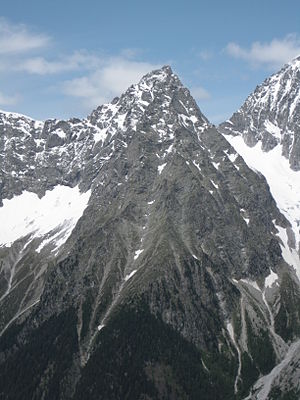
The Wildgall from the south east of the Red Wall seen from |
||
| height | 3273 m slm | |
| location | South Tyrol , Italy | |
| Mountains | Rieserferner Group | |
| Dominance | 0.77 km → Hochgall | |
| Notch height | 292 m ↓ Black notch | |
| Coordinates | 46 ° 54 '10 " N , 12 ° 8' 10" O | |
|
|
||
| First ascent | August 18, 1872 by Victor Hecht with the mountain guides Johann and Sepp Ausserhofer from Rein in Taufers over the Rieserferner and the Schwarze Scharte | |
The Wildgall (Italian Collaspro ) is at 3,273 meters the third highest mountain in the Rieserferner group , a mountain range in the western part of the Hohe Tauern . It is located in the Italian province of South Tyrol in the Rieserferner-Ahrn Nature Park ( Parco Naturale Vedrette di Ries-Aurina ) and appears from the south as a massive pyramid with pronounced ridges. Of the peaks of the Rieserferner group, it is considered to be the most difficult to access peak. That is why the Gall was conquered relatively late. The first ascent was made on August 18, 1872 by Victor Hecht from Prague and the mountain guides Johann and Sepp Ausserhofer from Rein in Taufers . Today the mountain can be reached in about four hours from the Kasseler Hütte (Italian: Rifugio Roma alla Vedrette di Ries ) to the north, but is rarely climbed.
- For the origin of the name see article Hochgall
Location and surroundings
The Gall is part of the Rieserferner main ridge, which runs in an arc from northeast to west and is surrounded to the north and west by the rapidly shrinking glacier Ostlicher Rieserferner . Neighboring mountains are in the northeast, separated by the Schwarze Scharte at an altitude of 2981 meters, the Hochgall , at 3,436 meters the highest peak in the area, and in the southwestern course of the ridge the Hochflachkofel , 3,097 m. Seen from the Antholz valley to the south, the Gall looks very dominant and dominates the northern panorama of Lake Antholz (water level at 1641 m). Important places in the northwest are Rein im Reintal , about 7 km as the crow flies, and Antholz-Mittertal about 5 km to the south .
geology
See article Schneebiger Nock
Development, routes and base
The route of Victor Hecht's first ascent in 1872 led from Rein in the northwest in the direction of Hochgall up to the Schwarzen Scharte. From there they turned to the southwest in order to reach the summit via the Wildgall north ridge, but failed after reaching a pre-summit on an impassable cliff and had to turn back. With a renewed ascent further from the west, the group climbed an approximately 45 ° inclined ice channel. The ascent through this rockfall-endangered ice channel is still the normal route today , with a level of difficulty of UIAA III in fragile rock. The first climbers needed about 8 hours for their tour. Today the Gall is climbed from the Hochgallhütte (at 2276 meters, west of Rein at the end of the Bachertal ) in about 4 hours.
Literature and map
- Werner Beikircher: Alpenvereinsführer Rieserfernergruppe , Bergverlag Rudolf Rother , 1983, ISBN 3-7633-1227-7
- Helmut Dumler: Area Guide South Tyrol 3 , Bergverlag Rudolf Rother, Munich 1987, ISBN 3-7633-3300-2
- Carl Diener in Eduard Richter (ed.): The development of the Eastern Alps , III. Volume, Berlin 1894
- Casa Editrice Tabacco , Tavagnacco, hiking map 1: 25,000, sheet 035, Valle Aurina / Ahrntal, Vedrette di Ries / Rieserferner group
Individual evidence
- ^ Journal of the German and Austrian Alpine Association , Volume IV, Munich 1873, p. 221 ff.
- ↑ a b Helmut Dumler: Area Guide South Tyrol 3 , Bergverlag Rudolf Rother, Munich 1987, p. 376
- ^ A b Carl Diener in: The development of the Eastern Alps , III. Volume, Berlin 1894, p. 116 f.


