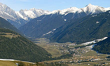
Antholz Valley
The Antholz Valley or simply Antholz ( Italian: Valle di Anterselva ) is a side valley of the Puster Valley in South Tyrol ( Italy ). It branches off from the Pustertal near Olang in a northerly direction and continues in a north-easterly direction from Antholz Mittertal . The entire valley belongs to the municipality of Rasen-Antholz . The valley extends over 21 kilometers to the Staller Sattel (2052 m), the transition to the East Tyrolean Defereggental . In the west and north the valley is surrounded by the mountains of the Rieserferner groupdominates, in the east rise the Villgraten mountains . The valley is traversed by the Antholzer Bach . At an altitude of 1642 m is located in the valley of 44 hectares large Lake Anterselva , which, like much of the orographic right Talflanken in the Rieserferner-Ahrn is placed under protection.
geomorphology
The wide valley floor turns into steep slopes on both sides of the valley, in particular the rear valley area is bordered by the mighty mountains of the Rieserferner group. The area is determined by numerous trenches, gullies, ridges, ridges and ridges running through the stream. Due to this geomorphological characteristic, there have always been Mur slopes in the valley . The deposited debris and alluvial cones have filled the valley floor, often relocated the course of the Antholz Brook and in the past dammed numerous lakes, the remains of which still exist in the form of raised bogs . Lake Anterselva is the only closed body of water that has been preserved. The third largest natural lake in South Tyrol was created by the bilateral discharge and the accumulation of mighty debris cones.
geology
Geologically, the Antholz Valley lies in the transition area between the Eastern Alpine Alto crystalline and Rieserferner Pluton . The old crystalline is mainly composed of orthogneiss , paragneiss and mica schist . The mountain range of the Rieserferner group in the rear Antholz valley, which consists of the Rieserferner tonalite , is, however, an Alpine intrusion and is therefore one of the plutonites of the Eastern Alps. Approximately south of the Rammelstein - Amperspitze line are the somewhat more acidic rocks of the “Antholz gneiss”. It is muscovite leading granite gneiss , which are often clearly visible, disseminated feldspar crystals have. In the broad valley floor, larger areas are covered by alluvial cone material, interrupted by recent, fluvidal deposits. Moraine ceilings as evidence of the glacial overprint are only present locally in the valley due to the steepness of the terrain.
climate
According to the Walter - Lieth classification, the valley's climate corresponds to the Central European montane to subalpine types in variants influenced by the ocean . The outer Antholz Valley is still relatively low in precipitation with 800 mm of annual precipitation; towards the end of the valley, precipitation increases significantly due to frequent northern impoundments and is 1,300 mm per year in the alpine regions. The mean annual temperature in Antholz is 6.5 ° C.
flora

The forest landscape is dominated in the high-montane level by extensive spruce stands . They are replaced by subalpine spruce forests at altitudes between 1600 and 1700 meters and finally change into stone pine forests between 1900 and 2000 meters . The latter can be found on both sides of the valley, but mainly on the orographic left side of the valley. The tree line is 2200 meters. In areas where the tree line has been shifted more downwards due to alpine farming, stone pine can also be completely absent. In the lowlands along the streams and on the alluvial fans there are gray alder forests , this is especially true for about 35 ha large wetland "Rasner Moser", a moor where the vast gray alder stands as Niederwald be used. Green alder is more widespread in the water-drawn gullies on the slopes .
Due to the cold air lakes in winter inversions , you can find high alpine flowers in the valley floor. The round-leaved sundew can also be found .
Settlements
There are several villages and settlements in the Antholz Valley, all of which belong to the municipality of Rasen-Antholz . The lowest village at the entrance to the valley is Niederrasen , followed by Oberrasen , Antholz Niedertal , Antholz Mittertal and finally Antholz Obertal .
Web links
Individual evidence
- ↑ a b c d e Forestry Department of the Autonomous Province of Bolzano - South Tyrol : Forest classification of South Tyrol. Volume 2: Forest groups, natural spaces, glossary. Page 268, Bozen 2010
- ^ Compass Lexicon for Map No. 82, Taufers-Ahrntal. 1994, ISBN 3-87051-091-9
Coordinates: 46 ° 51 ' N , 12 ° 6' E
