
Staller saddle
| Staller Saddle (Passo Stalle) | |||
|---|---|---|---|
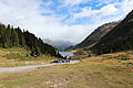
 Traffic lights at the border crossing on the Staller Sattel, looking west into the Antholz Valley (Italy) |
|||
| Compass direction | west | east | |
| Pass height | 2052 m above sea level A. | ||
| Antholz Valley ( South Tyrol , Italy ) | Defereggental ( East Tyrol , Austria ) | ||
| Watershed | Antholzer Bach → Rienz → Eisack → Etsch | Schwarzach → Isel → Drau → Danube | |
| Valley locations | Rasen Antholz | Sankt Jakob in Defereggen | |
| expansion | Single-lane pass road, one-way regulation ( Strada Provinciale 44 ) | Defereggental-Strasse (L25) | |
| Built | September 14, 1974 (completion as a passable, cross-border pass road) | ||
| Winter closure | Late October to mid May | ||
| Mountains | Rieserferner Group (north) Villgraten Mountains (south) | ||
| particularities | Hourly one-way regulation (only west side) |
||
| profile | |||
| Ø pitch | 4.7% (1045 m / 22.4 km) | 4.9% (663 m / 13.4 km) | |
| Max. Incline | 10% | 10% | |
| map | |||
|
|||
| Coordinates | 46 ° 53 '16 " N , 12 ° 11' 58" E | ||

The Staller Sattel ( Italian Passo Stalle ) is a mountain pass in the Eastern Alps . It connects the Antholz Valley ( South Tyrol ) in the west with the Defereggental ( East Tyrol ) in the east and separates the Rieserferner group in the north from the Villgraten mountains in the south. The pass is at an altitude of 2052 m . Since the Treaty of Saint-Germain came into force in 1920, the border between Italy and Austria has run across the Staller Sattel .
The pass is only open 24/7 from mid-May to late October. On the Italian side, due to the narrow street width, there is a one-way regulation and a traffic ban for caravans and buses. The drive from the top of the pass to the west is possible from the 1st to the 15th minute, the drive from Lake Anterselva (Italy) in the direction of Austria from the 31st to the 45th minute of the hour. A corresponding regulation by traffic lights exists.
gallery
View into the Defereggental with the Obersee (East Tyrol, Austria)

Traffic lights in the Antholz Valley on the Italian side
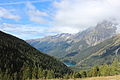
View of the Antholz Valley (Italy) from the Staller Sattel, on the far right the Wildgall (3272 m)
_-_1.JPG)


Web links
Agnello • Aprica • Assietta • Aurine • Borcola • Bordala • Brennero / Brenner • Brocon • Cadibona • Campo Carlo Magno • Campolongo • Camporosso (Saifnitzer) • Carnizza • Castrin / Hofmahd • Cereda • Ciampigotto • Cibiana • Cimabanche • Coe • Colombardo • Croce d'Aune • Croce Domini • Crocette • Costalunga / Karer • Duran • Eira • Eores / Kofel • Esischie • Erbe / Würz • Falzarego • Fauniera • Fedaia • Finero • Finestre • Foppa • Foscagno • Furcia / Furkel • Fusine (Ratschacher ) • Gavia • Gardena / Grödner • Giau • Gola / Klamml • Gran San Bernardo • Kreit • Lavazè • Livigno • Lombarda • Lúsia • Lys • Maddalena • Manghen • Mauria • Mendola / Mendel • Mont Rest • Monte Croce / Plöcken • Monte Croce di Comélico / Kreuzberg • Monte Giovo / Jaufen • Mortirolo • Nevea • Nigra / Niger • Palade / Gampen • Pampeago / Pale / Reiter • Pénnes / Penser • Pian delle Fugazze • Piccolo San Bernardo • Pordoi • Pramollo (Nassfeld) • Predil • Resia / Reschen • Rolle • Russis • Rombo / Timmel • Sampeyre • San Antonio • San Boldo • San Giovanni • San Lugano • San Marco • San Pellegrino • Santa Maria (Umbrail) • Sella • Sestriere • Sommo • Spluga (Splügen) • Stalle / Staller • Staulanza • Stelvio / Stilfser • Tanamea • Tenda • Tonale • Tre Croci • Tremalzo • Valles • Valcavera • Valparola • Vezzena • Vivione • Zovo
Ahorn • Alpl • Ammer • Annaberg • Arlberg • Ascher • Bieler • Birkfelder • Boding • Brenner • Buchauer • Buchener • Dientner • Dürrholzer • Eibegg • Erb • Eisental • Faschina • Feistritz • Fern • Filzen • Flattnitz • Flexen • Forsthof • Furka • Fuscher • Gaberl • Gaden wide • Gailberg • Gangleit • Geiseben • Gerichtsberg • Gerlos • Geschriebenstein • Goller • Grießen • Griffner • Large Kripp • Grubberg • Grünbacher • Gschuett • Hafner • Hahntenn • neck • Haselrast • Hebalm • stallion • Hengstl • Hiaslegg • Hirschegger • Hochegger • Hochrindl • Hochtannberg • Hochtor • Holzleiten • Iselsberg • Josefsberg • Kaiserauer • Cold Kuchl • Kartitscher • Katsch • Kernhofer • Kerschbaumer • Klachauer • Klamm • Klamml • Small Kripp • Klippitz • Klostertaler • Kraxen • Kreuth • Kreuzberg • Kühtai • Lahn • Lienbach • Loibl • Losen • Luft • Mendling • Michelbühel • Moarigraben • Nassfeld • Neumarkter • Niederalpl • Norberts • Nöring • Obdacher • Oberjoch • Och • Pack • Paulitsch • Perchauer • Pfaffen • Pfarralm • Pielachtaler • Piller • Plöcken • Pogusch • Pölshals • Pötschen • Präbichl • Prebersattel • Preiner • Pretal • Promau • Pyhrn • Radl • Radling • Radstädter • Radstatt • Rams • Raneck • Rechberg • Rieder • Rohrer • Sattler • Saurüssel • Schaida • Schanz • Scharflinger • Schiestel • Schober • Schönfeld • Schwarze Sau • Schwarzenbichl • Seeberg • Seefelder • Semmering • Kleiner Semmering • Sieggraben • Silzer • Soboth • Summer • Staller • Styrian Seeberg • Straßegg • Sölk • Thurn • Timmels • Triebener Tauern • Turracher • Origin • Wechsel • Weinebene • Weißenbacher • Wagrainer • Windische • Wurzen • Zellerrain