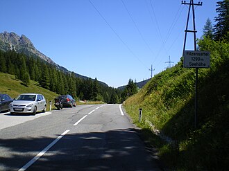
Felt saddle
| Felt saddle | |||
|---|---|---|---|
|
Pass height with information sign |
|||
| Compass direction | west | east | |
| Pass height | 1290 m above sea level A. | ||
| district | Zell am See | ||
| Watershed | Urslau , Saalach , Salzach , Inn , Danube | Filzenbachl, Dientenbach , Salzach, Inn, Danube | |
| Valley locations | Maria Alm | Served | |
| expansion | B164 | ||
| Mountains | Salzburg Slate Alps / Berchtesgaden Alps | ||
| profile | |||
| Ø pitch | 4.3% (488 m / 11.3 km) | 6.8% (190 m / 2.8 km) | |
| Max. Incline | 15% | 14% | |
| map | |||
|
|
|||
| Coordinates | 47 ° 23 '50 " N , 13 ° 0' 6" E | ||
The Filzensattel is a 1290 m above sea level. A. high mountain pass between Hinterthal / Maria Alm am Steinernen Meer in Pinzgau and Dienten am Hochkönig in Salzburg . The B 164 , which leads from Saalfelden over the Dientner Sattel to Bischofshofen , leads over the saddle . The Filzensattel forms the lowest transition between Filzenkopf ( 1513 m above sea level ) in the north and Gabühel ( 1596 m above sea level ) in the southwest of the saddle.
Individual evidence
- ↑ a b c ÖK 50 www.austrianmap.at , Federal Office for Metrology and Surveying Austria, Austrian map.

