Silzer saddle
| Silzer saddle | |||
|---|---|---|---|
|
View from the north ramp into the Oberinntal |
|||
| Compass direction | North | south | |
| Pass height | 1690 m above sea level A. | ||
| state | Tyrol , Austria | ||
| Valley locations | Haiming | Ox garden | |
| expansion | Pass road | ||
| Mountains | Stubai Alps | ||
| profile | |||
| Denzel scale | SG 2 | ||
| Ø pitch | 10.6% (1020 m / 9.6 km) | 8% (152 m / 1.9 km) | |
| Map (Tyrol) | |||
|
|
|||
| Coordinates | 47 ° 13 '53 " N , 10 ° 55' 39" E | ||
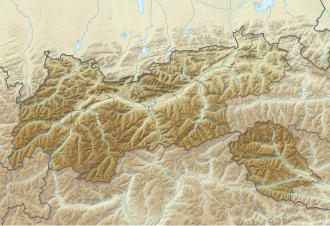
The Silzer Sattel (in the ÖK50 Sattele ) is a Tyrolean Alpine pass that connects the Oberinntal with the parallel Nedertal . Coming from the Oberinntal near Haiming , the road overcomes the saddle more than 1000 meters in altitude and reaches an altitude of 1690 m above sea level. A. its highest point. From there to the village of Ochsengarten on Kühtaistraße (L237) this then only drops about 150 meters.
Web links
Individual evidence
- ↑ Denzel, Harald; Great Alpine Road Guide; 22nd edition; Denzel-Verlag Innsbruck 2005, ISBN 3-85047-764-9
- ^ Austrian Map online 1: 50,000 (ÖK 50) of the BEV


