
Ox garden
|
Ochsengarten () locality |
|||
|---|---|---|---|
|
|||
| Basic data | |||
| Pole. District , state | Imst (IM), Tyrol | ||
| Pole. local community | Haiming ( KG Haiming) | ||
| Coordinates | 47 ° 13 '44 " N , 10 ° 56' 22" E | ||
| height | 1538 m above sea level A. | ||
| Residents of the village | 147 (January 1, 2020) | ||
| Post Code | 6433 | ||
| Statistical identification | |||
| Locality code | 16418 | ||
| Counting district / district | Haimingerberg-Ochsengarten (70202 001) | ||
 The Haiming district of Ochsengarten |
|||
| Source: STAT : index of places ; BEV : GEONAM ; TIRIS | |||

The village of Ochsengarten is one of six fractions ( localities ) of the municipality of Haiming in Tyrol , located on the northwestern edge of the Stubai Alps . With around 150 inhabitants, it forms one of the smaller fractions of the municipality.
geography
In addition to the main town, the Rotte Wald, the fraction consists of the Rotte Kössl, the hamlet of Unterhäusern , the scattered houses Marlstein and Obergut and the individual farms Marail and Zwirch.
Ochsengarten is located in the Nedertal , on the western ramp of the pass road that leads up from the valley floor of the Ötztal to the Kühtaisattel . The main traffic artery that connects Ochsengarten with the administrative center of the municipality of Haiming in the Inn Valley runs along this road. However, due to the route via Oetz , this traffic line has to cross foreign municipal areas. A direct connection to the own community center is only a side road that overcomes the 1690 meter high Silzer Sattel from Ochsengarten and then runs down from there to the Oberinntal .
Barely a piece of the western edge of Ochsengarten away is the valley station of the ski area Hochoetz leading up Ochsengartenbahn .
location
Ochsengarten is a fraction of the municipality of Haiming and includes the districts of Wald, Innerwald, Ausserwald, Balbach, Unterhäusern, Kößl, Obergut, Zwirch, Marlstein and Marail at an altitude of 1,500 to 1,790 m.
Ochsengarten is the middle part of the Nedertal, a side valley of the Ötztal and extends upstream on the Nederbach from the Kugartenwand to Marail. With the exception of Balbach, all settlements are on the sunny side of the valley. In terms of the geological substructure, Ochsengarten lies on rock, moraine and rubble soils. The moraine area of forest made it possible to use the soil as pasture. There is the largest clearing island in the lonely forest valley. The main settlement is called the forest after its previous land cover.
history
A Schwaighof in Ochsengarten was mentioned in a document as early as 1315 , which is one of the oldest permanent high alpine settlements in Tyrol. Since 1627 Haiming, Schlierenzau and Ochsengarten together formed a main municipality of the Petersberg court . In 1777 the Church of the Visitation of the Virgin Mary was built, in 1778 the ox garden became a chaplain, in 1885 a locality and in 1891 it was made a parish.
photos
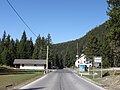
Eastern entrance to the village

The elementary school in the newly built schoolhouse in 1953

The church

The valley station of the Ochsengartenbahn


literature
- Freytag & Berndt-Verlag Vienna, hiking map 1: 50,000, sheet WK 252, Imst, Landeck, Telfs, Fernpass . ISBN 978-3850847551