
Kühtai saddle
| Kühtai saddle | |||
|---|---|---|---|
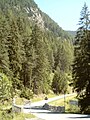
 View of Kühtai, the pass road runs from the bottom left (coming from the Ötztal) through the winter sports resort. |
|||
| Compass direction | west | east | |
| Pass height | 2017 m above sea level A. | ||
| state | Tyrol , Austria | ||
| Watershed | Nederbach → Ötztaler Ache → Inn | Stockacher Bach → Zirmbach → Melach → Inn | |
| Valley locations | Oetz | Kematen | |
| expansion | L237 Kühtaistraße | L13 Sellraintalstraße | |
| Mountains | Stubai Alps | ||
| profile | |||
| Ø pitch | 6.9% (1205 m / 17.5 km) | 5.4% (1407 m / 26.0 km) | |
| Max. Incline | 18% | 16% | |
| Map (Tyrol) | |||
|
|||
| Coordinates | 47 ° 12 '50 " N , 11 ° 1' 25" E | ||

The Kühtaisattel is a Tyrolean alpine pass that connects the Ötztal through the Nedertal with the Sellraintal . The watershed runs at a height of 2017 m above sea level. A. across the hotel resort Kühtai , a particularly remote district of Silz .
A state road leads over the pass as Sellraintalstraße (L13) from Tiroler Straße near Zirl to Jagdschloss Kühtai and from there as Kühtaistraße (L237) to Oetz and Ötztalstraße . In contrast to most of the other Alpine passes, the Kühtaisattel can be bypassed relatively easily, in this case through the Inntal , the pass road primarily serves to develop Kühtai.
In the Ötztal, the ramp begins at Oetz and is 17.5 km long and has a maximum gradient of 18%. The Kematen ramp is 26 km long and has a maximum gradient of 16% between Gries im Sellrain and Kühtai.
The Kühtaisattel is the first mountain test in the Ötztal Cycle Marathon . Because of the relatively low density of motor vehicle traffic, the Kühtaisattel is often used by racing cyclists and ambitious touring cyclists .
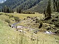
photos

West ramp above Oetz

West ramp, view of Oetz
West ramp, exit Mühlau
West ramp, Nederbach

Pass summit in Kühtai
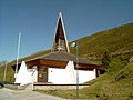
Church in Kühtai on the top of the pass

Beginning of the east ramp at the Kühtai exit

Avalanche protection tunnel in the east ramp

Ostrampe, Zirmbach


Individual evidence
- ^ Kühtai and the surrounding area on ÖK 50 , www.austrianmap.at , Federal Office for Metrology and Surveying Austria, Austrian map.
literature
- Harald Denzel: Great Alpine Road Guide . 21st edition, Denzel-Verlag Vienna 2001. ISBN 3-85047-764-9
Web links
Ahorn • Alpl • Ammer • Annaberg • Arlberg • Ascher • Bieler • Birkfelder • Boding • Brenner • Buchauer • Buchener • Dientner • Dürrholzer • Eibegg • Erb • Eisental • Faschina • Feistritz • Fern • Filzen • Flattnitz • Flexen • Forsthof • Furka • Fuscher • Gaberl • Gaden wide • Gailberg • Gangleit • Geiseben • Gerichtsberg • Gerlos • Geschriebenstein • Goller • Grießen • Griffner • Large Kripp • Grubberg • Grünbacher • Gschuett • Hafner • Hahntenn • neck • Haselrast • Hebalm • stallion • Hengstl • Hiaslegg • Hirschegger • Hochegger • Hochrindl • Hochtannberg • Hochtor • Holzleiten • Iselsberg • Josefsberg • Kaiserauer • Cold Kuchl • Kartitscher • Katsch • Kernhofer • Kerschbaumer • Klachauer • Klamm • Klamml • Small Kripp • Klippitz • Klostertaler • Kraxen • Kreuth • Kreuzberg • Kühtai • Lahn • Lienbach • Loibl • Losen • Luft • Mendling • Michelbühel • Moarigraben • Nassfeld • Neumarkter • Niederalpl • Norberts • Nöring • Obdacher • Oberjoch • Och • Pack • Paulitsch • Perchauer • Pfaffen • Pfarralm • Pielachtaler • Piller • Plöcken • Pogusch • Pölshals • Pötschen • Präbichl • Prebersattel • Preiner • Pretal • Promau • Pyhrn • Radl • Radling • Radstädter • Radstatt • Rams • Raneck • Rechberg • Rieder • Rohrer • Sattler • Saurüssel • Schaida • Schanz • Scharflinger • Schiestel • Schober • Schönfeld • Schwarze Sau • Schwarzenbichl • Seeberg • Seefelder • Semmering • Kleiner Semmering • Sieggraben • Silzer • Soboth • Summer • Staller • Styrian Seeberg • Straßegg • Sölk • Thurn • Timmels • Triebener Tauern • Turracher • Origin • Wechsel • Weinebene • Weißenbacher • Wagrainer • Windische • Wurzen • Zellerrain