
Sellraintalstrasse
| State road L13 | |||||||||||||||||||||||||||||||||||||||||||||||||||||||||||||||||||||||||||||||||||||||||||||||||||||||||||||||||||||||||

|
|||||||||||||||||||||||||||||||||||||||||||||||||||||||||||||||||||||||||||||||||||||||||||||||||||||||||||||||||||||||||
| Basic data | |||||||||||||||||||||||||||||||||||||||||||||||||||||||||||||||||||||||||||||||||||||||||||||||||||||||||||||||||||||||||
| Start of the street: |
Zirl ( 47 ° 16 ′ N , 11 ° 16 ′ E ) |
||||||||||||||||||||||||||||||||||||||||||||||||||||||||||||||||||||||||||||||||||||||||||||||||||||||||||||||||||||||||
| End of street: |
Kühtai ( 47 ° 13 ′ N , 11 ° 1 ′ E ) |
||||||||||||||||||||||||||||||||||||||||||||||||||||||||||||||||||||||||||||||||||||||||||||||||||||||||||||||||||||||||
| Overall length: | 26.68 km | ||||||||||||||||||||||||||||||||||||||||||||||||||||||||||||||||||||||||||||||||||||||||||||||||||||||||||||||||||||||||
|
State : |
|||||||||||||||||||||||||||||||||||||||||||||||||||||||||||||||||||||||||||||||||||||||||||||||||||||||||||||||||||||||||
 |
|||||||||||||||||||||||||||||||||||||||||||||||||||||||||||||||||||||||||||||||||||||||||||||||||||||||||||||||||||||||||
| Mugkögele and Marcheck gallery | |||||||||||||||||||||||||||||||||||||||||||||||||||||||||||||||||||||||||||||||||||||||||||||||||||||||||||||||||||||||||
|
Course of the road
|
|||||||||||||||||||||||||||||||||||||||||||||||||||||||||||||||||||||||||||||||||||||||||||||||||||||||||||||||||||||||||
The Sellraintalstraße (L 13), unofficial and historically also Sellrainer Straße and Sellrainer Landesstraße , is a state road in Tyrol . It leads from Zirl in the Inn Valley through the Sellraintal into Kühtai and is 26.7 km long.
course
The Sellraintalstraße branches off from the Tiroler Straße (B 171) to the south between Martinsbühel and Zirl and initially leads over the Inn and under the Inntal autobahn (with a connection from / towards Innsbruck ), crosses under the Arlbergbahn and passes Kematen . It then runs parallel to Melach through the narrow gorge at the entrance to the valley to Sellrain and on through the Sellrain valley via Gries im Sellrain , St. Sigmund im Sellrain and Haggen to the Kühtai winter sports resort . The road ends after crossing the Kühtai saddle ( 2017 m above sea level ) at the Kühtai hunting lodge and continues as Kühtaistraße (L 237) through the Nedertal down to Oetz to the Ötztalstraße .
From Zirl to Kühtai, the Sellraintalstraße overcomes a length of 26.7 kilometers and 1420 meters in altitude. In many places the road is endangered by falling rocks , mudslides or avalanches and has protective structures such as retaining walls and galleries . The longest structure is the Mugkögele and Marcheckgalerie between Haggen and Kühtai with a length of 614 m.
history
Archduke Leopold V had the first road through the Sellrain into Kühtai laid out from 1623 to 1628, who liked to hunt there and subsequently had a Schwaighof converted into a hunting lodge.
Until the 19th century, the Sellraintal could only be reached via the low mountain range terraces ( Grinzens or Oberperfuss ), and there was not even a footpath through the inaccessible Melach Gorge at the valley exit. The first plans for a road through the gorge appeared in 1858, and in 1865 the planned route from Kematen to Rothenbrunn (Sellrain) was measured, which was paid for by Wilten Abbey . With the opening of the Arlbergbahn in 1883, the plans for a direct connection from the Kematen train station to Sellrain were given new impetus. Especially the Wilten Abbey, which held the manorial power in the upper section and in the side valleys of the Sellrain Valley, but also the German and Austrian Alpine Associations campaigned for it. In September 1886, a consortium led by Wilten Abbey agreed to build the road.
At the New Year of 1887 construction began with the first rock blasting and on November 4, 1887 Abbot Laurentius Müller inaugurated the 3 meter wide street and opened it to traffic. Wilten Abbey paid 17,000 of the 27,000 guilders construction costs, the rest was raised by landlords and tradespeople from Kematen and the Sellrain as well as the Alpine Association. However, there was no support from the state of Tyrol and the valley communities. A toll was initially collected to maintain the road . In 1905 a competition was formed to cover the costs of building and maintaining the road.
The new road shortened the way from Kematen to Rothenbrunn compared to the connections via Grinzens or Oberperfuss from 11 or 9 km to 4½ km and led to an upturn in tourism in the Sellraintal. However, it was regularly affected by floods and rockfalls.
The connection from Sellrain via Gries and St. Sigmund to Kühtai was still just a cart path . From 1927 to 1930 the road was expanded and extended to Gries, on July 1, 1930, the Postbus service to Gries could be started.
For the use of the section between Haggen and Kühtai, a toll was levied to cover the costs of clearing snow from 1960 to 1972 in the winter months.
For the construction of the Sellrain-Silz power plant group , the Sellraintalstraße was generously expanded between 1975 and 1979 and partially re-routed.
traffic
In 2018, an average of 11,070 vehicles were counted at the Kematen Nord counting station and 2,893 vehicles were counted at the Sellrain counting station in 24 hours.
gallery

in Kematen at the junction with Axamer Straße

Gries through the town
Avalanche barriers at the Zirmbachalm

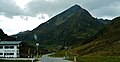
End of Kühtai


Web links
Individual evidence
- ↑ a b Office of the Tyrolean Provincial Government (Ed.): Statistisches Handbuch Bundesland Tirol 2019. Innsbruck 2019, pp. 11 and 15 ( PDF; 14.2 MB )
- ↑ Beatrix and Egon Pinzer: Castles Palaces ruins in North and East Tyrol . Edition Löwenzahn, Innsbruck 1996, ISBN 3-7066-2122-3 , p. 61 .
- ^ Maria Gassner: Contributions to the settlement and economic history of the inner Selraintal. Publications of the Museum Ferdinandeum in Innsbruck, issue 4, Innsbruck 1925 ( PDF (18.9 MB) on ZOBODAT )
- ↑ a b c d Georg Jäger: Glacier milk and cherry soup: meager life on the Melach. Historical forays through the Sellraintal . Universitätsverlag Wagner, Innsbruck 2012, ISBN 978-3-7030-0811-5 , p. 54-64 .
- ↑ a b Georg Jäger: Alpine history in a nutshell: Sellraintal region. Austrian Alpine Club, Innsbruck 2015 ( PDF; 2.2 MB )
- ↑ Provincial Law Gazette for Tyrol, No. 12/1961.
- ↑ Provincial Law Gazette for Tyrol, No. 24/1972.
- ^ Office of the Tyrolean Provincial Government, Transport Planning Section (Ed.): Verkehr in Tirol - Report 2018. Innsbruck 2019, Annex 1 ( PDF; 2.2 MB )