
Alps
| Alps | ||
|---|---|---|
 Satellite image of the Alps |
||
| Highest peak | Mont Blanc ( 4810 m ) | |
| location | France , Monaco , Italy , Switzerland , Liechtenstein , Germany , Austria , Slovenia | |
| Region in | Europe | |
|
||
| Coordinates , ( CH ) | 47 ° N , 10 ° O ( 796 589 / 153063 ) | |
| Type | Ceiling / fold mountains | |
| Age of the rock | 290–35 million years, in places significantly older ( protoliths up to approx. 1,750 million years) | |
| surface | 200,000 km² | |

The Alps are the highest high mountains in the interior of Europe . It stretches from the Ligurian Sea to the Pannonian Basin in an arc of 1200 kilometers long and between 150 and 250 kilometers wide .
overview


The entire Alpine region covers an area of around 200,000 square kilometers. It extends about 750 km from west to east and about 400 km from south to north and is bordered by the Rhone Valley , the Swiss Plateau , the upper reaches of the Danube , the Little Hungarian Plain , the Po Valley and the Gulf of Genoa .
The Alpine arc joins the Apennines in the southwest on the Gulf of Genoa , includes the Po plain, branches off to the French and Swiss Jura and ends in a fan shape in the east in front of the western Pannonian mountain and hill country. In the northeast on the Danube near Vienna, the Alps are separated from the geologically related Carpathians by the Vienna Basin , in the southeast they merge into the heavily karstified Dinaric Mountains . In the north, the Alps gradually descend to the Austrian and German Alpine foothills . In the south, the slope to the Po plain is steeper. The mountain range to which the Alps belong extends from the African Atlas to Southeast Asia .
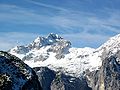
The summit heights in the western mountain ranges are mostly between 3000 and 4300 meters above sea level , in the Eastern Alps the mountains are a little lower. The highest peak in the Alps is Mont Blanc at 4810 meters. 128 mountains in the Alps are four-thousand-meter peaks , and many mountains are more or less glaciated . The Alps are divided into numerous mountain groups and chains.
The Alps form an important climate and watershed in the "heart of Europe" . They separate the central Mediterranean area with the Etesia climate from the Atlantic- influenced northern Central Europe and are under continental influence on the eastern edge . The drainage also follows these major directions to the Mediterranean, North Sea and Black Sea .
The alpine region comprises areas of the eight alpine states France , Monaco , Italy , Switzerland , Liechtenstein , Germany , Austria and Slovenia . It is the living space of 13 million people and enjoys European importance as a recreational area. Hungary has shares in low mountain ranges that are counted as part of the Alps, for example the Günser and Ödenburger mountains , but are usually not counted as part of the Alpine region. Alpine valleys and passes have also been important trans-European transport links since early history.
Word history
The Alps are referred to as mountains relatively late in literature. It was not until Hannibal's procession through the Alps in 218 BC. Brought her to the notice. A clear definition is given by Polybius († around 120 BC), who gives reliable information on Alpine passes. The terms Alpeis (singular) and Alpēs (plural) appear around 150 AD in Ptolemy's geography, written in Greek (e.g. Alpes Poeninae / Summo Poenius for Great St. Bernhard ; see also Peutinger's table ). In Etymologiarum sive originum libri XX , Isidore of Seville confirms that the Roman conquerors took over the word alp , meaning 'high mountain, high pasture' from the Ligurian-Celtic mountain population. The connection with the Indo-European color adjective * albʰos 'white', which was often assumed in the past , is unlikely.
In the Middle Ages, the word alp and the Latin mons were used equally for passes, pass heights, transitions and individual elevations and then gradually replaced by the Alemannic mountain . The endings -berg in passport names bear witness to this . From the 18th century, mountain is increasingly used for individual peaks and elevations, and the Alps refer to the entire mountain range. Bibliography required

Today's word family is diverse:
- The original meaning of Alpe is still alive today in the Alemannic-speaking area: in Vorarlberg and Tyrol as Alpe , in Switzerland since the Middle Ages shortened to Alp , in Swabian as Alb ; in Bavarian with the meaning "mountain pasture" ground to Alm .
- The Italian and Rhaeto-Romanic name alpina for a high forest made of Swiss stone pine and Scots pine also corresponds to this concept, but is not used for interpretation.
- Remnants of the meaning “pasture” can still be found in many places (and not limited to the Alps) in field names such as Alpe or Aelpli .
- As a transferred name, the Alps appear in the names of other mountains, e.g. B. Apuan Alps , Australian Alps , Japanese Alps , New Zealand Alps .
- Alpine also generally means “mountainous”, e.g. B. alpine level (a high mountain level ), or is synonymous with "mountain", z. B. alpine climbing , alpine skiing .
- Alpid describes a geological phase of mountain formation. The Alpid mountain belt stretches from Europe to East Asia.
structure


Attempts to divide the Alps have been made on various bases for centuries. Such classifications are based on cultural and human geographic features or natural components and structures such as orography , geomorphology , geology , hydrology , climate or flora and fauna . These classification systems have led to small-scale classifications, the diversity of which can hardly be overlooked and which include numerous locally and regionally different names, some of which overlap and contradict each other.
In the course of time, especially with regard to the geographical breakdown of the entire mountain range, two systems have emerged that can only partially be reconciled with one another and leave a lot of room for fundamental misunderstandings. A major commonality of both systems, however, is the tripartite division along the entire Alpine chain into a central part and an outer part on the arch (north and west) and an inner part (south).
Division of the Alps in two
In Austria, South Tyrol and Germany, the Alps are divided into the main units Western and Eastern Alps . This structure picks up on the geological and the geomorphological differences derived from them that arise in the transition from Switzerland to Austria, for example on the Alpine Rhine Valley - Lake Como line , especially in relation to the northern half of the Alpine chain. This dichotomy is widespread in the scientific and legislative context as well as in the division of the Eastern Alps into the Alpine Club (Moriggl 1924, Rev. 1984), or the SOIUSA ( Suddivisione Orografica Internazionale Unificata del Sistema Alpino , Marazzi 2005)
Tripartite division of the Alps


In Italy and France there is a traditional, uniform threefold division of the Alps into western, central and eastern Alps , the Partizione delle Alpi (1924), which is based less on geological criteria than on historical geographical agreement. According to the geographical breakdown used in France and Italy, the Western Alps begin on the Mediterranean Sea and extend to the Aosta Valley - Mont Blanc line, the Central Alps lie between Aosta Valley / Mont Blanc and the Brenner Pass and the Eastern Alps stretch from the Brenner Pass to Slovenia.
This three-way division can also be found in the division of the Swiss Alps according to SAC , which in this sense largely covers the Central Alps.
Other outlines
The breakdowns that deal with the climate , vegetation or settlement of the Alps are just as varied :
- from the outside to the inside three regions: Alpine foothills , foothills and inner-alpine region
- the rough topographical breakdown into middle mountainous peripheral zones and the high Alps with summit heights over 1500 m
- the biogeographically defined height belt of the Alpine: Alpine valleys including the hills stage (to about 700-900 m), the mountain stage to the upper timber line (1500 to 2000 m), the high mountain stage or Alpin stage to the snow line (2000-3100 m) and above in the nival level with the glacier regions.
- Typical mountain forms of the large parts of the Alps

Northern Eastern Alps (Northern Alps): Karwendel main chain

Central Eastern Alps (Central Alps): Großvenediger
Southern Eastern Alps (Southern Alps); Triglav

Central Western Alps: La Meije

Southwestern Western Alps: Monte Argentera


Mountain ranges and mountain groups
Eastern Alps
The Eastern Alps extend from Swiss territory across Austria (from Vorarlberg to Burgenland ) and Italian Alpine provinces (from the province of Sondrio through Trentino and South Tyrol to Friuli ) to Slovenia . The Alpine regions of Germany and the State of Liechtenstein belong to the Eastern Alps. The highest peak in the Eastern Alps and their only four-thousand-meter peak is the Piz Bernina (4049 m) in the Swiss canton of Graubünden .
They are divided into three units by the large longitudinal valley furrows:
- The Northern Alps are divided into Subalpine Molasse , Flysch Zone , Northern Limestone Alps , Slate Alps and Greywacke Zone . The Bavarian and Austrian Alpine foothills connect to the north . The dominant feature here is the contrast between the rounded shapes of the sandstones against the rugged walls of the limestone Alps.
- The central Alps are rich in springs, streams and cirque lakes, and in the west there are several glaciers. They consist of granite, gneiss and mica slate and therefore form wide-span mountain vaults with predominantly rounded shapes.
- In the Southern Alps , the Southern Limestone Alps form the main part, with jagged battlements, towers and sticks. The deeply cut Bozen porphyry plateau merges into the crystalline Sarntal Alps in the north . In the south there is only a narrow pre- Alpine zone and, together with the southern Alpine foreland, forms the transition to the Po Valley .

Western alps


The Western Alps are the part of the Alps that lies west of the Lake Constance - Rhine - Splügen Pass - Lake Como line . They connect to the Apennines to the north of the Gulf of Genoa and encompass the Po Valley in a wide arc to the west .
The following countries have a share in the Western Alps:
- Monaco
- France . The highest mountain in France and the Alps is Mont Blanc (4810 m).
- Italy . The highest mountain in Italy is commonly considered to be the Mont Blanc de Courmayeur (4748 m), a secondary peak of Mont Blanc. From an Italian point of view, however, the border runs over the main summit (see border on Mont Blanc ).
- Switzerland . The highest mountain in Switzerland is the Dufourspitze (4634 m) in the Monte Rosa massif of the Valais Alps .
The Western Alps are higher than the Eastern Alps, their central chain is shorter and strongly curved. The western Alps have 81 four-thousand-meter peaks (as defined by the UIAA ). Here you can also find the highest passes in the Alps , including the Col de l'Iseran in Savoy, at 2764 m the highest Alpine pass.
Units of the Western Alps

A series of crystalline central massifs is separated more or less sharply from a gneiss zone in the south and a limestone zone in the west and north by valleys that are partly long-lasting in the stroke of the mountains . As in the Eastern Alps, a rough threefold subdivision of the Western Alps into north-south or north-west-south-east direction can be made. To the west and north, a limestone zone forms rugged walls and battlements against the respective foreland. The chain of the central massifs, which are isolated from one another, has the highest mountains in the Alps, with wide mountain vaults and high sticks of often bizarre shapes. Because of their height, many massifs are glaciated, with the Aletsch Glacier in the Bernese Alps being the longest glacier in the Alps. The mountains of the gneiss zone drop from the Po plain with great differences in altitude. To the north, the central western Alps descend to the Swiss plateau , in the west the Provencal chains sink under the young deposits of the Rhône valley.
The following major units of the Western Alps can be distinguished:
| Limestone zone | Central massifs | Gneiss zone |
|---|---|---|
In Switzerland , the Alps located in the country are also divided into the northern flank of the Alps, the western and eastern central Alps and the southern Alps located in Ticino (→ Swiss Alps ).
geology
The Alps are geologically young fold mountains with a correspondingly characteristic ceiling structure .
Large geological units
In the course of geological research, the Alps have been divided into several large units, each of which is characterized by its own sequence of rocks and regions of origin. The following units are distinguished from north to south:
|
|
|

The large units are broken down into a number of sub-units. The geological assignments differ in some places from the primarily orographic mountain groups, as the large longitudinal valley ranges of the Alps primarily follow the rock boundaries or the tectonic fracture and fault lines, but also cut through these zones in places.
Formation of the Alps
The geological unfolding of the Alps as a multi-stage process began around 135 million years ago at the turn of the Jurassic - in the Cretaceous period , had the last important phase around 30 to 35 million years ago in the Tertiary , but continues in a milder form. From a plate tectonic point of view, the Alps belong to the young blanket mountains of the Alpid mountain range , which also include the Caucasus and the Himalayas . The intensive geological research of the past century led to the idea of a narrowing of an ocean that was once over 1000 km wide with continental margins, deep-sea basins and mid-ocean ridges to the less than 100 km width of today's Alps.
Plate tectonic processes

In the Mediterranean region, mountain formation can be traced back to the continual opening of the Atlantic. As a result, the African continent was broken out of Pangea and pressed against Europe in a twisting motion. In between was the Adriatic Plate, which was enclosed by two arms of the ocean that stretched from the Atlantic to the Tethys . On the southern edge of the continental crust of Europe, the rocks of the Helvetic were formed . To the south of it, the North and Middle Pennines emerged in the northern of the two arms around the Adriatic Plate. Even further south of it was the Adriatic Plate with the Eastern and Southern Alps.
With the opening of the North Atlantic in the Middle Dogger, according to paleomagnetic data, about 170 million years ago, the formation of the South Penninic from oceanic crust began in the Paratethys north of the Adriatic plate. At the same time, the first mountain-forming processes took place in the deposit area of the Eastern Alps, which ultimately led to the stacking of the Upper Eastern Alpine nappes. During the Cretaceous, the opening of the South Atlantic (about 125 million years ago) set in motion the subduction and accretion of the South Penninic to the Eastern Alpine (known as the Altalpidische Bergbildung or Eoalpine Orogonese ). As a result of these processes, the Pennine Ocean began to close again.
From the Eocene , about 53 million years ago, Africa moved directly northward, driving the Adriatic plate like a spur into the southern area of Europe. The collision and with it the first large compressive orogeny phase lasted only about 5 million years from the Upper Eocene to the Lower Oligocene ( Jungalpid or Pyrenean phase). The Eastern and Southern Alps were pushed over onto the Middle Penninic, and areas of thinned crust were pushed under. With the further collision, the North Penninic and finally the Helvetic were driven over until the structure of the alpine ceiling building was completed in the Pliocene . With thrust widths of several hundred kilometers, this narrowing led to the current ceiling structure of the Alps. In the maximum of the Alpid orogeny, the mountains grew by about 5 mm per year in height. It has not come to a standstill even today, as the continental plates continue to move towards each other at about 5 cm per year.
Sedimentation history

In the Palaeozoic , the formation of Pangea resulted in a folded base made of granite , gneiss and other types of rock; some of these were later included in the mountain-building processes in the Alpine folds. Since the Triassic period , the supercontinent broke apart, and marine sedimentation began on the continental margins of the Adriatic plate in the south and the European plate in the north . In the Lower Triassic, salt-bearing strata ( Werfen strata ) formed in the deposit area of the Eastern Alps on the north and east edge of the Adriatic Plate, suggesting an arid climate . In the further course of the Triassic, the limestones of the Eastern Alpine nappes were deposited here ( Alpine Triassic ), which essentially make up today's limestone Alps. In the area of the later Helvetic nappes, mainly sand and clay stones were deposited on the southern edge of the European plate during this period ( Germanic Triassic ).
During the Jurassic and Cretaceous Periods, limestone and dolomite were often deposited in the Tethys region on the edges of the European continent and the Adriatic plate. In the sea areas that formed in between, clayey deep-sea sediments were formed, which were associated with submarine volcanism. The sediment thicknesses from this time are very different and often changed abruptly over short distances. After the subduction of the Middle Penninic under the Eastern Alps began, flysch began to form in front of the accretion wedge . On the back of the migrating northward ceiling stack the "Gosau Sea" penetrated into basins of the emerging Eastern Alps and stored fossil-rich marl and sandstone of Gosau layers (Cretaceous) from.

With the onset of the collision with the European continent and the subsequent complete elevation of the mountain body above sea level, parts of it were increasingly subject to erosion. A sedimentation only took place in the upstream edge zones. Here still emerged Flyschablagerungen (Cretaceous - Lower Tertiary) that have been run over in the course increasingly from the rock mass. After the formation of an only narrow marginal sea, the flysch sedimentation passed into the deposits of the molasses, clayey-sandy sediments from the alpine body, which are later pushed over by the flysch at the edge and partly included in folds.
Sustained uplift and formation
The Alps became high mountains through the lifting of the folded mountain body, which continues to the present day. The isostatic equalization in the crust lifted the mountains, whose erosion from the Lower Oligocene onwards filled the molasse basin to the north . The mountain-forming pressure continues to this day, but the growth in height is only about 1 mm per year. Horizontal movements of the earth's crust can, however, be somewhat larger regionally, for example in regions with tremors.
The current mountain shape was given to the Alps through erosion, especially through the erosive activity of the glaciers during the glacials of the ongoing Ice Age .
The geological youthful age of the Alps can be seen in the rugged rock faces, the sharp ridges and in the deep and steep valleys with uneven gradients. The interplay of uplift and erosion (by glaciers, rivers , frost , sun ) with the storage and resistance of the strata shapes the Alps to this day. Through the modeling (modeling reshaping) in the cold ages, the glaciers shaped the picture and created new surface structures, such as ridges and cirques through periglacial weathering and glacial erosion ; After the ice receded, lakes and terminal moraines formed .
Surface shapes depending on the rock

The surface form and other geomorphological conditions depend on the rocks of the respective mountain units. Karst phenomena arise in the limestone . Water-impermeable dolomite is heavily crushed, with brittle rock formations and heaps of rubble made of fine gravel. In the hard gneisses and granite gneisses , because of the large gaps between the fissures, mostly coarse blocks form during weathering, which can form extensive blocks of rubble . Due to the weathering of wool sacks , which is characteristic of granite, bizarre rock formations can be observed in many places.
The sequence of layers of the rock units causes the occurrence of further geomorphological phenomena. At the base of the mighty limestone series, such as that of the Northern Limestone Alps and the Helvetic Mountains, there are often spring horizons ( karst springs ) above impermeable slates . Areas with impermeable mica slate under granite and gneiss with their mostly large, well-water-permeable crevices are also rich in springs, streams and cirques. The salt and gypsum deposits present in the Northern Limestone Alps are noticeable in the surface design, similar to limestone rocks, through karst phenomena.
climate
features

The Alps are one of the most important climatic divisions in Europe and separate the Atlantic climate province , the Pannonian climate province and the Mediterranean climate . In general, the Alps are characterized by a very small-scale climate and weather conditions due to the strong relief .
The most important climatic influences are westerly winds with mild, moist air masses from the Atlantic, cold polar air from the north, dry continental air masses from the east (cold in winter, hot in summer) and warm Mediterranean air from the south, which each form typical congestion positions .
Special winds are the foehn , a warm fall wind, primarily in a south-facing position as south foehn, more rarely in the other direction than north foehn, as well as the mistral of France.
The direct solar radiation is higher due to the lower density of the atmosphere in the higher altitudes, at the same time the diffuse radiation is lower. This increases the difference between sunny and shady slopes.
Climatic regions
- Large parts of the Northern Alps resemble the neighboring flatlands in terms of their annual thermal cycle, with the exception of the decrease in the mean annual temperature (by 0.50 to 0.65 ° C per 100 m increase in altitude). The maximum precipitation is reached in summer. The peripheral areas of the Alps exposed to westerly winds often receive 2000 to 3000 mm of precipitation per year ( Central European transitional climate ) .
- The southern parts of the Alps are influenced by the Mediterranean climate. Compared to Central Europe, this leads to mild winters and hot summers and to a shift in the maximum precipitation towards spring and summer; with the characteristic, only with heavy rain water carrying dry river valleys ( torrents of the Italian Plain) and pronounced Canyon Education ( Gorges of southern France, Posočje 2500 m profile).
- The eastern edge of the Alps has a summer-dry continental-Pannonian wine-growing climate , increasingly wetter again towards the south ( Illyrian climate province )
- The inner-alpine valleys and basins ( Wallis , Vinschgau , Carinthia ) are in the rain shadow and are therefore dry (often less than 800 mm per year). In winter, especially in basin areas ( Lungau , Klagenfurt Basin ), the temperature reverses ( inversion weather conditions ): in low areas, there are cold air lakes due to the calm , so that it is colder here than at medium altitudes.
Consequences of global warming in the Alps


Due to climate change, the glaciers are melting drastically. Climatic fluctuations are not unknown, and glaciers are a climate archive . Glaciers are retreating faster today than they used to be. According to measurements, the glaciers lost a third of their area and half of their mass between the beginning of industrialization and 1980. Since 1980, an additional 20 to 30 percent of the ice volume has thawed (see glacier retreat since 1850 ).
Central aspects associated with the phenomenon of climate change are:
Thawing the permafrost, higher amounts of precipitation
In the foreground is the striking glacier melt , which is less supporting rocks due to the melting of glaciers and snowfields. Two other points play a more important role in destabilizing the soil. On the one hand, the increased precipitation tendencies lead to more floating layers of the earth and more landslides below the permafrost limit; on the other hand, the permafrost limit is shifting to higher mountain regions. Former areas stabilized by permafrost are now exposed to the alternation of freezing and re-thawing ice and are thus destabilized, on the one hand because ice is no longer required as cement, and on the other hand because the anomaly of the water breaks the rock when it freezes.
Numerous villages are at risk from rockfalls , rubble and debris avalanches , as well as roads and hiking trails. With the help of protective dams, valleys and infrastructure can be protected.
Role for the water balance
Glaciers reduce the temperature microclimatically through their reflectivity. They thus promote the escape of humidity through snowfall. In contrast, they play almost no role in the water balance of large rivers. On the one hand, glaciers are only water reservoirs (there is no water in them, on the contrary: they evaporate considerable amounts of water compared to streams and rivers), on the other hand, the specific amounts of water (water per unit of time) are small despite their enormous size because the Storage times are just as huge.
Loss of biodiversity
Today it is assumed that climate change causes many plant species to move to higher altitudes. Since there is a temperature difference of 0.6 K per 100 m difference in altitude and the temperature in the Alps has increased by an average of 1.5 K in the last hundred years, a change in altitude of around 20 to 25 m per decade should be purely mathematical. According to studies in 1994, however, this is around 4 m per decade; more recent studies from 2005, on the other hand, speak of 28 ± 14 m per decade.
This calculation does not take into account the fact that high alpine plants have adapted to a variety of conditions, of which temperature is an obvious one, but only one of many conditions. UV radiation, wind, lack of water, soil conditions, food and light competitors also count. The competitive situation in particular plays a major role: in most cases, the high alpine plants do not grow in these inhospitable regions because they cannot cope with better conditions, but because areas with better conditions are already occupied by other plants. As long as these competitors do not move up, the high alpine plants will not leave their locations voluntarily. In the long term, however, there will be a move up, but this process is partly linked to very slow processes (e.g. soil formation processes), so that it will only be completed after centuries and sometimes even millennia.
As a result, more species live at higher altitudes today than was the case 100 years ago. However, there is a limit to this 'moving up' with the sheer summit height. At the moment, however, there are no indications that the existing plants are being displaced by the 'Aufrücker', as they occupy a solid ecological niche as pioneers in the severe erosion of the mountain peaks.
Still, some scientists estimate that a quarter of the 400 endemic plant species are threatened with extinction because they will eventually displace their habitats. The temperature problem is only one, however, erosion from tourism and building activities is another.
Biogeography
The Alps are an interzonal mountain range, they lie between the Zonobiom VI ( winter-cold mountains with deciduous forests ) in the north and the Zonobiom IV ( Mediterranean zonobiom ) in the south. Therefore, the north and south sides differ quite a lot. In addition, there is the strongly continental vegetation of the inner alpine valleys. In the Alps, the colline elevation level extends to around 400 m, the submontane level from 400 to 700 m. In addition to the exposure and altitude, the nature of the soil also plays a decisive role in the development of the vegetation. Above all, various lime and silicate sites should be mentioned here. Added to this are factors such as the duration of snow cover and the water supply.
In the system of the Biogeographical Regions of the European Union (92/43 / EEC), the Alpine Region represents an independent unit.
flora


In the Alps, around 650 species of flowering plants have their main distribution, a total of around 4500 species occur in the Alpine region.
The alpine flora contains many arctic-alpine elements, such as the Saxifraga aizoon . They are relics of the end of the last glacial period , when tundras ruled Central Europe . There are also connections to the North Asian mountains ( e.g. Gentiana verna ). Due to glaciation, the alpine flora contains relatively few endemic species, only in the southern Alps, which have remained ice-free, endemics are more common.
What is striking in the Alps is the difference in species composition between the limestone Alps and the silicate rocks. Franz Unger already pointed this out in 1836. In addition to the different soil chemistry, this is due to the fact that limestone soils are warmer and drier. In many cases, genera are represented by closely related species (ecological vicariance ). As an example, in addition to the rhododendrons already mentioned (lime - silicate): the ferns Asplenium ruta-muraria and A. septentrionale ; the cushion plants Sedum album and S. annuum ; the cushion sedge ( Carex firma ) and the crooked sedge ( C. curvula ).
The vegetation is therefore dependent on the prevailing rocks, the different units each have typical regional vegetation. In the Eastern Alps, the Northern Alps are predominantly covered by mixed spruce forests; In the Central Alps there are extensive mountain meadows, larch and spruce forests .
Plant species typically identified with the Alps are often species with conspicuous flowers: above all the Alpine edelweiss ( Leontopodium alpinum ), the rhododendrons and the blue gentian species ( Gentiana spp.).
Montane level
In the montane forest level, the following sequence of levels of dominant tree species results:
- Helvetic altitude level sequence: In the temperate Central European climate on the northern edge, the sequence is from bottom to top: oak - red beech - spruce .
- Penninische altitudinal sequence: In continental dry interior valleys of the Central Alps, the order pine - spruce - Arve / larch . Here the tree line is 400 to 600 m higher than at the edge of the Alps.
- Insubric altitude level sequence: On the sub-Mediterranean southern edge the sequence is evergreen stone oak - chestnut / downy oak - stem oak - red beech.
The upper tree line is today largely determined by humans and varies greatly (1400 to 2000 m). The alpine farming that has existed for centuries has pushed the tree line down.
The following terms have also been introduced for the montane forest level:
- lowest wooded part ( JG Sulzer 1745)
- Forest Mountains ( Albrecht Penck 1896)
- Pre-Alps ( Johann Gottfried Ebel 1808)
Subalpine level

The subalpine level (up to about 1900–2200 m) forms the transition ( ecoton ) from the forest level to the treeless alpine level. It is characterized by a shrub step. In dry locations, such as those that predominate on carbonate rock but also on silicate blocks, this is the mountain pine ( Pinus mugo ), on loamy soils, which occur over large areas in silicate areas, the green alder . Both of them are about as tall as a man. Both types also climb much deeper in avalanche channels, as they can withstand snow pressure due to their flexibility. The high sub- alpine level is formed by the dwarf juniper and the two rhododendrons (alpine rush): Rhododendron hirsutum (on limestone) and Rh. Ferrugineum (limestone soils).
Other terms introduced:
- Viehalpen ( JJ Wagner 1680)
- Alps (JG Sulzer 1745)
- Cow pens ( Karl Albrecht Kasthofer 1818)
- Mattengebirge ( Penck 1896)
Alpine stage
The alpine stage (up to about 2500-3000 m), JJ Wagner Alps , is a mountain tundra by various turf is formed which cover the ground remains largely closed. The " Aperzeit ", ie the time without snow cover, is particularly decisive for the vegetation . Further factors are the exposure to wind (especially the resulting absence of snow in winter) and the rock substrate. Due to these factors and the restless relief, a very small-scale vegetation mosaic results.
.jpg)
The most important lawn communities in the Limestone Alps are the Rostseggenrasen (Caricetum ferrugineae) on deep soil , the Seslerio-Caricetum sempervirentis on more shallow soils and the Caricetum firmae on limestone rocks. On acidic rock the crooked sedge (Caricetum curvulae) is dominant, on overgrazed lawns the grass pasture (Nardetum). The limestone lawns in particular are characterized by their abundance of flowers.
The effect of the aperitif is particularly evident in the snow valleys . These are mostly located at the foot of the northern slopes of the Silica Alps in the upper Alpine level. A lot of snow accumulates here in winter, which thaws late or not at all in summer, which creates different zones around the remaining snow. With an Aperzeit of over three months the normal crooked sedge grows, with a shorter Aperzeit the herb-willow becomes more frequent, which soon dominates and forms the Salicetum herbaceae. Characteristic species are alpine motherwort and alpine bell . With an average aperitif of less than two months, mosses dominate, especially Polytrichum sexangulare .
Ranging from huts form warehouses corridors . Nutrient-loving tall perennials grow on the areas that have been fertilized and compacted - and therefore damp - by the cattle.
Characteristic is the society on the edge of the wind with the dominating Gamsheide ( Loiseleuria procumbens ).
Nivale level
.jpg)
The nival level (or region according to Oswald Heer 1838), according to Penk (1896) also snow and ice mountains are above the climatic snow line. Plants only thrive in places where the snow does not stay or where it melts early in summer. A vegetation cover is only very small, plants often grow sporadically. Around 150 species of flowering plants rise above 3000 m, as well as many lichens . On rising highest flowering plants belonging to the Glacier Buttercup , but the altitude record held by the saxifrage Saxifraga biflora to 4450 m at the Dom de Mischabel in Valais .
The firn areas of the glaciers are populated, among other things, by Chlamydomonas nivalis , a green alga that causes the “red snow” or blood snow .
fauna


In the lower layers, the fauna of the Alps corresponds to that of the surrounding plains. In the coniferous forests to several types of find boreal forest . They are tied to cool and humid conditions, repopulated Europe from the east in the post-glacial period and are only found in central Europe today in the high altitudes. Only in a few spatially isolated refuges that remained unglaciated during the Pleistocene Ice Ages could some pre-glacial fauna elements survive, for example certain snails and beetles.
Many characteristic alpine animals live above the tree line, in the Oreal. For some species, this is likely to be interpreted as avoiding humans. Many are related to species of the tundra and occur there as well. There are also close relationships with other high mountains . The high mountain fauna of Europe is often remnants (relic populations) of Ice Age fauna, which has disappeared again post-glacial in the lower-lying landscapes - a process known as area disjunction . By origin are arcto-alpine distribution types (origin of tundra) and boreo-alpine distribution types (origin from the Taiga distinction).
Typical species of mammals include chamois , alpine ibex , marmot and snow vole , while the birds include alpine chough , common raven , ring owl , snow finch , golden eagle , jay and Ptarmigan . Brown bears can still be found in the Slovenian Alps and in the Adamello Nature Park in Trentino , Italy. Since the 1990s there has been a small population of these predators in the Austrian Alps through immigration from Slovenia and targeted reintroductions. Most of them live in the area of the Ötscher-Tormäuer Nature Park . Wolves were exterminated in the Alps around 1900, but returned from the Apennines around 1990 . Today around 100 wolves live in the Italian and French western Alps. While the golden eagle is widespread in the northern hemisphere, in Central Europe it is restricted to the Alps and Carpathians . Several large animals have been exterminated, including the lynx , bearded and griffon vultures , which are now beginning to re-establish themselves through protective measures and reintroduction projects. In some vertebrates , a seasonal dimorphism can be observed: a dark summer coat of hair or feathers is replaced by a white camouflage costume in winter (compare: mountain hare , ptarmigan). Among the amphibians , the black colored alpine salamander has developed a special adaptation to the alpine habitats. The Alpine salamander is the only Central European amphibian to be viviparous . The development of the larvae in the uterus of the female takes two to three years, depending on the altitude. This means that the species is independent of surface waters in which the larvae of other amphibian species complete their development. The alpine salamander occurs at altitudes of up to 2800 meters (Austria).
The reptile species forest lizard and adder - both are common in the Alps from montane to alpine - have adapted to adverse external conditions, especially low temperatures, with the switch from oviposition to live birth. In Switzerland, the aspis viper , another ovoviviparous snake species, is found up to an altitude of 3000 meters. The sand viper, also known as the European horned viper , and the mountain scorpion can also be found in the southern Limestone Alps .
Among the typical insects of the Alps, for example, “furry” representatives of the bumblebees stand out ( Alpine bumblebee , Bombus alpinus ), while particularly dark forms are to be found among the butterflies , for example the Eismo Eiskurfalter ( Erebia pluto ). However, light species such as the light alpine blue ( Plebejus orbitulus ) and the alpine apollo ( Parnassius phoebus ) still occur at altitudes of 3000 meters. On the other hand, orb web spiders are apparently not represented in higher regions, presumably because of the numerical regression of flying insects and because of the wind exposure .
Among the few animals Nivalzone include the hairy, black colored Gletscherfloh ( Isotoma saltans ), a great-insect from the class of springtails and glaciers trechus ( Trechus glacialis ), a species of ground beetles .
The Alpine Space in the Europe of the Regions

Alpine countries and countries bordering the Alps are Austria , Italy , France , Switzerland , Germany , Slovenia , Liechtenstein and Monaco (arranged according to their share in the total area of the Alps).
Against the background of the European internal market, cross-border cooperation in the Alpine region has been intensified since around 1970. In 1972 the working group Alpine countries ( Arge Alp ) was founded. In 1991 the Alpine Convention was finally signed, an international convention for the protection of the Alps. The International Commission for the Protection of the Alps ( CIPRA ) , founded in 1952, had worked for a long time towards this goal .
In the modern, regionally- related European spatial development concept (ESDP) of a Europe of Regions , the Alpine region is once again given greater weight as a transnational economic and cultural unit. The Alps - with the surrounding Alpine foothills and bordering regions - form one of the INTERREG areas of the European Regional Development Fund , which tries to increase the attractiveness and competitiveness of the entire region with its Alpine Space program.
Settlement and traffic

Settlement areas
Settled and economically developed in the Alps are mainly the large alpine valleys, especially on the axes that are suitable for through traffic, as well as in the regions that open up to basins. In addition, the mining regions have also been developed, and since the beginning of the 20th century purely tourist centers ( spa centers , alpine centers ). However, the main settlement areas are still the edge of the Alps , and the majority of the large Alpine cities are located at the outflows of the rivers into the foothills.
While trade , commerce and industry are concentrated in these main settlement areas, the agricultural settlement area is extensive and thin, and over 40% of the alpine area is not inhabited permanently or not at all, but serves as a summer pasture area (Alps / pastures for cattle breeding), are purely forestry Region or completely unusable.
Urban and rural exodus
In the area of tension between the limited economic and settlement areas, the phenomenon of urban flight can be seen, which has led to increasing depopulation of the Alps since the 16th century, and the later mountain flight through inner-Alpine migration to the centers. The trend only stopped in the late 20th century, and only in certain regions. Today about 13.6 million people live in the Alps, in 1950 there were about 10.8 million in the same area, in 1870 7.8 million, but this increase is below the average increase for the entire Alpine countries. Only Austria, Germany and Slovenia were able to increase their population (with an extreme focus on Bavaria including the Austrian border areas), in Switzerland and France it is more or less stable in the long term, but almost 90% of all Alpine communities in France are recording a population decline (mountain exodus), Italy but has lost almost a quarter of its Alpine population to other regions (urban exodus, extreme areas: Friuli , Piedmontese Alps).
Avalanche disasters (e.g. 1954 in Vorarlberg ) as well as devastating debris flows and floods are also part of the settlement history of the Alps .
Cities
Grenoble in France is the largest city in the Alps , followed by Innsbruck in Austria and Trento and Bolzano in Italy. In Switzerland, Chur , Thun and Lugano are in the Alps. Other alpine cities in Austria are Klagenfurt and Villach , as well as Bregenz , Dornbirn and Feldkirch in the Rhine Valley . Also to be mentioned is Vaduz , the capital of Liechtenstein. The highest city in the Alps (and Europe) is Davos in Switzerland .
On the edge of the Alps, Vienna is by far the largest city, followed by Geneva (Switzerland) and Nice (France). Other important cities are - from east to west - Maribor (Slovenia), Graz (Austria), Ljubljana (Slovenia), Udine (Italy), Salzburg (Austria), Vicenza (Italy), Verona (Italy), Brescia (Italy), Bergamo (Italy), St. Gallen (Switzerland), Lecco (Italy), Como (Italy), Varese (Italy), Lucerne (Switzerland), Savona (Italy), Biella (Italy), San Remo (Italy), Cuneo ( Italy), Bern (Switzerland) and Monaco .
Transit traffic


.jpg)


The Alps are an important European connecting area. Especially economically, the Alps represent an important transit area between Northern and Southern Europe. They can only be crossed on certain routes via mountain passes or tunnels , since the Alps are a natural obstacle to trans-European traffic. A particular problem is that the air exchange takes place under difficult conditions due to frequent inversion weather conditions and the elevations in the Alps. This means that pollutants linger longer than average in the alpine valley atmosphere.
The passes that lead over the main Alpine ridge directly from north to south or vice versa into well-developed valleys, thus saving a second pass crossing or routes that were little affected by floods and avalanches, became particularly important. Crossings such as the Col de Montgenèvre and the Great St. Bernhard in the western and the Septimer and Julier Passes in the central Alps were already converted into traffic routes by the Romans , as were the Reschen Pass and Brenner in the east. Other legendary routes such as Hannibal's route with his army and war elephants - presumably over the Col de Clapier - did not develop into main traffic routes. At the end of antiquity , Itinerarium Antonini and Tabula Peutingeriana record seven crossings of the main Alpine ridge. In the Middle Ages , when access routes such as the Schöllenen Gorge and the Viamala (1473) were made passable, the St. Gotthard and Splügen Pass as well as the San Bernardino were used more, while the Septimer and Lukmanier Passes lost their importance. As early as 1430, over 90 percent of long-distance trade between Augsburg and Venice - 6,500 freight wagons per year - was handled via the Brenner. The expansion of the Kuntersweg to a road in the Eisack Valley between Bozen and Klausen and the Kesselbergstraße above Kochel am See in 1495 made the Brenner the most important crossing of the Eastern Alps in 1480 .
A selection of the most important transalpine connections ( Alpine transversals , from west to east, the main pass in italics ):
- Marseille - Nice - Tendapass - Cuneo - Turin
- Avignon - Sisteron - Barcelonnette - Col de Larche / Colle della Maddalena - Cuneo - Mondovì - Genoa
- Nîmes - Tarascon - Apt - Sisteron - Briançon - Col de Montgenèvre - Susa - Turin ( Via Domitia )
- Vienne - Chambéry - Albertville - Bourg-Saint-Maurice - Little Saint Bernard - Aosta Valley - Milan ( Alpis Graia )
- Lyon - Chambéry - Mont Cenis or Fréjus - Susa - Turin
- Dijon - Geneva - Chamonix - Mont Blanc - Aosta - Turin
- Besançon - Lausanne - Martigny - Great St. Bernard - Aosta Valley - Vercelli - Pavia - Piacenza - Parma ( Alpis Pœnina )
- Dijon - Lausanne - Brig - Simplon - Domodossola - Milan
- Karlsruhe - Freiburg im Breisgau - Basel - Bern - Lötschberg - Brig - Simplon - Domodossola - Milan
- Stuttgart - Zurich - Lucerne - Göschenen - St. Gotthard - Airolo - Bellinzona - Milan
- Ulm - Memmingen - Bregenz - Chur - San Bernardino - Bellinzona - Milan
- Augsburg - Füssen - Reutte - Fernpass - Imst - Landeck - Reschenpass - Merano - Bozen - Verona ( Via Claudia Augusta )
- Augsburg - Landsberg am Lech - (or: Munich -) Garmisch-Partenkirchen - Mittenwald - Seefelder Sattel - Innsbruck - Brenner - Bozen - Verona ( Via Raetia )
- Munich - Rosenheim - Kufstein - Innsbruck - Brenner - Bolzano - Verona
- Munich - Rosenheim - Bad Reichenhall - Salzburg - Radstädter Tauernpass - Spittal - Villach - Udine - Portogruaro - Mestre or Spittal - Villach - Udine - Trieste
- Wels - Pyhrnpass - Liezen - Graz - Maribor - Ljubljana - Trieste
- Vienna - Wiener Neustadt - Semmering - Bruck an der Mur - Graz - Maribor - Ljubljana - Trieste
The important inner-alpine transit routes that also establish the connection between the alpine crossings, in particular the longitudinal valley furrows , are:
- Nice - Digne-les-Bains - Gap - Grenoble - Chambéry - Geneva
- Geneva / Lausanne - Brig - Furka Pass - Oberalp Pass - Chur - Bludenz - Arlberg - Innsbruck - Zell am See - Bischofshofen - Liezen - Semmering - Wiener Neustadt - Vienna
- Como - Sondrio - Stilfser Joch or Tonale Pass - Bozen - Lienz - Villach - Klagenfurt - Packsattel - Graz
Industrialization and railways
The transit network through the Alps evolved over time faster: from narrow paths for packed mules and horses on early mountain passes of the 19th century to the multi-lane highways and railways in the 19th and 20th century. The railway has in the 19th century with pioneering achievements such as the Semmering Railway as a first standard gauge mountain railway in Europe or the Gotthard railway heralded the age of modern transit. In recent times, various railway transversals through the Alps have been built:
- in Switzerland these are the Lötschberg axis and Gotthard axis , which are grouped under the New Railway-Alpine Transversal (NEAT)
- in Austria the new alpine railways , the Brenner and Tauern railways , and in future also the Brenner base tunnel
- in France and Italy the new route through Mont Cenis
Due to natural hazards and the topography , transport projects in the Alps are always associated with high costs and dangers, which is also evident in the current construction of the NEAT, now known as AlpTransit , in Switzerland. The increasing environmental pollution from motorized transit traffic has often led to protests by the affected population, such as road blockades in Tyrol, Savoy, Piedmont and the Alpine Initiative in Switzerland. The possible alpine-wide introduction of an alpine transit exchange is currently being discussed.
See also:
Former passport states
In the late Middle Ages, peasant associations for the common use of resources led to the development of political structures called pass states because they stretched over both sides of the Alpine ridge . In addition to the League of Briançon , the Old Confederation , the Three Leagues , the County of Tyrol and the Archdiocese of Salzburg belong to it. This was intended to demand alpine freedom thinking analogous to the urban freedoms of the imperial cities . These passport states controlled transit traffic through their strategic position and imposed customs duties on travelers.
At the latest, however, the nation states of the 19th century sought to include what they saw as the peripheral Alpine region, so that, for example, Tyrol had to be divided between Austria and Italy. The Switzerland is the only alpine pass States, which has survived to this day. The Confederation of Confederation was transformed into a modern nation- state in 1848 through the establishment of the federal state .
Cultural history
Mountain farming
_mit_Kuh.jpg)

In the Alps, Neolithic agriculture displaced around 4500 BC. The hunters and gatherers of the Mesolithic . Dense forest cover initially made it difficult to use large grazing areas, but gradually transhumance developed in the Alpine region, in which the animals spend the summer in the heights and the winter in the valley. At about the same time, the alpine self-sufficiency with arable farming and cattle breeding in already cleared terrain was added, which enabled year-round settlement.
This self-sufficiency economy developed differently north and south of the Alps: while cattle breeding clearly dominated in the Germanic area , arable farming was equally well represented in the Romanic area. This led to different diets and regional cuisines as well as differences in the family and settlement structure.
Between 1600 and 1850 an independent mountain farming culture emerged, especially in the northern Alpine region , which manifested itself in the construction of magnificent wooden farmhouses and in which the sustainable use of nature as protection against natural hazards was in the foreground.
Industrialization reached the Alpine region in the 19th century . It was less industry than the service society of the 20th century that brought money to the Alpine valleys as tourism and ended the outstanding position of mountain agriculture. Many agricultural workers that had become redundant then emigrated. Under increasing economic pressure, the diversity of agriculture and forestry in the Alps has been dwindling since the second half of the 20th century, which is easier to operate because of the mechanization, but is no longer worthwhile.
Culture and language groups
In the early Middle Ages , the Alps developed into a language and cultural border between Germanic in the north and Romance language groups in the south and west, taking into account the South Slavic Slovenes on the eastern edge of the Alps. Today less and less remains of the variety of dialects that brought about the original isolation of the valleys. Despite the competition from the German and Italian languages , the small Alpine languages Romansh , Ladin and Friulian survived. An interesting phenomenon in terms of linguistic history is the spread of the Alemannic Walser dialect from Upper Valais to the Tyrolean border , which took place between the 13th and 14th centuries through the occupation and management of high-lying pastures.
regional customs

Festivities and customs in the Alpine region are deeply rooted in history and religion. They often emerged in connection with traditional poetry, sagas or tales that often dealt with gods and demons. People wanted to conjure up the elemental forces of nature and protect themselves from natural hazards. When Christianity penetrated the Alpine region in the early Middle Ages, pagan customs mixed with Christian celebrations. The widespread stone setting ( cairns ) seem to have both a practical and a cultic background. The rural element always played a prominent role in alpine customs and alpine folk music ( see also : Alpine blessing , cattle drive , yodelling , Alpine folk music ).
Alpine myth
The reception of the Alpine region fluctuates - as with all landscapes of extremes - in modern times between two closely interwoven poles, the myth of the force of nature and the purity of nature . What was previously thought to be an inhospitable wilderness inhabited by coarse farmers and dangerous dragons, painters, travelers and writers began to describe as a “dream landscape”.

A well-known Geneva naturalist, Horace-Bénédict de Saussure , interwoven scientific exploration and aesthetic sensibility in his travelogues in the late 18th century . When his contemporary Goethe traveled to the Alps , the mountains were also perceived as a phenomenon in northern Germany for the first time. ET Compton , the alpine painter, invented mountain painting as a subject at the end of the 19th century, which did not use the mountains as a backdrop, but tried to depict the mountain as a "personality". As a symbol of the mystification of the Alps in their “purity and sublimity” from Romanticism to the 21st century, the glow of the Alps - the reflection of dawn and evening red - is depicted in images and literature in many ways.
Mountain tourism in an increasingly bourgeois society of the 19th century also presents the Alps as a challenge to the individual, and “Victory on the Mountain” becomes a staging on which people can prove themselves and come closer to God. The summit cross symbolizes this tension between awe and the will to win. This also changes the reception of the alpine dweller, for whom this is part of their daily bread. Switzerland, which was previously transfigured as “Alpine democracy”, and the “free land of Tyrol” still feed on the Alpine myth of early Romanticism , even if Max Frisch or Paul Flora fought against it in their works. In France and Italy, however, there is a lack of cultural independence, here the Alpine provinces remain in a culturally peripheral location to this day. Modern Slovenia in its detachment from the Balkans takes up these myths and integrates the Alps into its identity as a “land of diversity”.

The First World War turned large areas of the Eastern Alps into an Alpine front , but the devastation of the Second World War left the Alpine region relatively spared. Both through the mythical transfiguration of the alpine dweller as a fighter against nature and enemy of the war and interwar decades, from " Mountains in Flames " to the "construction of the Glocknerstrasse " to the " Alpine fortress ", as well as those in the post-war years in comparison to the rest of Europe The intact economic situation has transformed the Alpine region from the poor and backward "development area" of the Enlightenment to the epitome of the "ideal world" (depicted in the Heimatfilm , for example ).
This complex of myths continues unbroken to this day. The mountains as a traffic obstacle are well developed, integrated into a common Europe as a cultural area, freely available as a tourist destination, and the environmental protection movement is discovering the alpine region as “ common property that is worth protecting”. A new component, however, is the modern man's feeling of superiority, in which the specific rigors of a montane environment are judged as an obstacle to be repaired in the smooth functioning of civilization.
tourism


The Alps are very intensively developed for tourism. As early as the 19th century, the English coined the term of the Alps as the “playground of Europe”. The variety of landscapes, cultural sights and the special climatic conditions offer almost optimal conditions for the tourist use of the Alps, as a large number of tourist target groups (e.g. those looking for relaxation, active vacationers, spa tourists, culture enthusiasts etc.) can be served with appropriate offers.
Summer tourism includes the various types of active and passive recreational tourism ( hiking , bathing holidays on the lakes at the edge of the Alps) and, above all, sporting holidays in the form of alpinism . This initiated the tourism development of the Alpine region. In winter tourism, the Alps are an attractive destination for winter sports around the world, with skiing and its various forms dominating in this regard . In the last few decades, winter tourism has overtaken classic summer tourism in many parts of the Alps.
Tourism history
The first events aimed at pleasure or fame take place in the Alps at the end of the 18th century with early first ascent, which still stand in the sense of an absolutism that glorifies the sovereigns. For the local peasant population, interest in the mountains ended at the vegetation boundaries.
English tourists in particular then decisively shaped alpine tourism as individual tourism in and especially towards the end of the 19th century . As early as the 19th century, the Englishman Thomas Cook organized mass trips from England to the Alps. During the first few years this affected the summer season, but as early as 1864 the Kulm Hotel in St. Moritz in Graubünden dared to open it up in winter and thus “invented” winter tourism.
The Belle Epoque opened up the Alps as a recreational area also for the upper classes of the country, and established the concept of summer retreat in the Alps. Since the heyday of hotels and villas in the health resorts , alpine tourism has also started to spread into winter. In the traditional health resorts, however, the summer season remained the main season until the 1970s.
The post-war decades made the Alps the goal of an urban society, first as a recreational area from the strains of an economic downturn, then as a recreational backdrop , as a status symbol of high living standards. Since about 1965 was also due to improved transport infrastructure of mass tourism development. The winter sports tourism with its cable cars and ski lifts got for the Alpine dwellers increasingly important to pure retort towns in the French Alps.
Hiking vacations became clearly more popular again after the turn of the millennium and are considered a prime example of ecologically compatible tourism ( soft tourism ); especially if it leads to remote valley regions that are threatened by emigration and helps to secure a source of income for the local population. Such tourism is served by various long-distance hiking trails, for example the Swiss cultural trails , or even long-distance hiking trails such as the Via Alpina long-distance hiking trail that crosses all eight Alpine countries . For this reason, the path was recognized in 2005 as an official implementation project of the Alpine Convention on the occasion of the promotion of sustainable development . In contrast to its title, the Italian route Grande Traversata delle Alpi is limited to the Piedmont region . In the “Model Region Göschenen ” in Switzerland, concepts for poorly developed areas were developed.
See also:
Benefits and dangers

For many Alpine communities, tourism has become the only source of income. Mass tourism creates jobs and generates regional incomes, which can reduce the risk of emigration. However, tourism in the Alps is often only selectively concentrated in certain villages, towns and ski resorts. In the larger areas without mass tourism, there is even more emigration. In fact, there is often a juxtaposition of intensely developed tourist areas and tourist no-man's-land. This applies above all to the Italian Alpine region and is summarized as the phenomenon of mountain exodus .
The people in the Alps are heavily dependent on mass tourism, tourist monostructures are emerging . All areas of life are subjected to mass tourism. Regional peculiarities or peculiarities may become a mere cliché . In addition, the working conditions in tourism are often not very attractive (unregulated working hours, low wages, many seasonal jobs). People who do not want to submit to these working conditions are forced to emigrate (or commute) all the more due to the lack of alternative employment opportunities.
Environmentalists all over Europe and many locals are increasingly criticizing the damage caused by mass tourism in the Alps and are increasingly pointing out the limits of the tourist use of the Alps. More and more traffic routes are being built through the Alps and village structures are being destroyed in favor of ongoing urbanization (example: Garmisch-Partenkirchen ). There are also ecological problems such as garbage and sewage pollution, traffic problems and “optical pollution” from technical infrastructures such as cable cars . The further expansion of tourist infrastructures is already reaching its limits in many Alpine valleys, especially since natural hazards ( e.g. avalanches , mudslides ) limit the available space. A number of tragic accidents, such as in Galtür in Tyrol in February 1999, have highlighted this problem. To accommodate holidaymakers, hotels are often built right in front of the ski slopes . If an avalanche breaks out on the slopes of a ski slope, it hits the hotels particularly hard, as the avalanches are unchecked by the absence of obstacles.

literature
General
- Werner Bätzing : The Alps - history and future of a European cultural landscape . 4th edition. CH Beck, Munich 2015, ISBN 978-3-406-67339-9 .
- Jon Mathieu : The Alps. Space - culture - history. Reclam, Stuttgart 2015, ISBN 978-3-15-011029-4 .
- Bernhard Edmaier , Angelika Jung-Hüttl: Artwork Alps . Bergverlag Rother, Unterhaching 2012, ISBN 978-3-7633-7060-3 .
- Joseph Partsch : Alpes . In: Paulys Realencyclopadie der classischen Antiquity Science (RE). Volume I, 2, Stuttgart 1894, Sp. 1599-1612.
- Heinz Veit: The Alps - geoecology and landscape development. 2nd Edition. UTB Ulmer, Stuttgart 2002.
- Werner Bätzing: Between wilderness and leisure park. A pamphlet on the future of the Alps. Rotpunktverlag, Zurich 2015, ISBN 978-3-85869-648-9
Main topics
- Jakob Anderhandt: The Alps West-East. Monsenstein and Vannerdat publishing house, Münster 2008, ISBN 978-3-86582-662-6 (long-distance hiking guide).
- Norman Backhaus, Claude Reichler, Matthias Stremlow: Alpine landscapes - from imagination to action. Thematic synthesis of research focus I “Processes of Perception” of the National Research Program “Landscapes and Habitats of the Alps”. (= Synthesis report NRP 48, Swiss National Science Foundation ). vdf-Verlag, Zurich 2007, ISBN 978-3-7281-3119-5 .
- Andrea Bonoldi, Hannes Obermair : Transport and Infrastructure - Trasporti e infrastrutture (= history and region / Storia e regione 25/2 ). StudienVerlag, 2017, ISSN 1121-0303 .
- Patrick Brauns : The mountains are calling. Alps languages myths. Verlag Huber, Frauenfeld 2002. ( Mountain names and languages in the Alpine region)
- Martina Kopf: Alpinism - Andinism. Mountain landscapes in European and Latin American literature. Stuttgart: Metzler, 2016. ISBN 978-3-476-05594-1
- Burkhart Lauterbach: The mountains are calling - Alpine tourism and cultural transfer since the 18th century. In: European History Online . ed. from the Institute for European History (Mainz) , 2010. Accessed June 14, 2012.
- Uwe A. Oster: Paths across the Alps. From the early days until today. Darmstadt 2006, ISBN 3-89678-269-X . (Transport geography and cultural history)
- Claude Reichler: Discovery of a Landscape. Travelers, writers, artists and their Alps. Rotpunkt-Verlag, Zurich 2005. (The reception of the Alps in art)
- Matthias Stremlow: The Alps from below. From the promise of the near stranger to the sports arena . Haupt-Verlag, Bern, 1998, ISBN 3-258-05848-2 . (Alpine myth and tourism)
- Roland Walter : Geology of Central Europe. Founded by Paul Dorn . 6th edition. Schweizerbart, Stuttgart 1998, ISBN 3-510-65167-7 .
- see also literature of the main articles: Alpine flora
-
The Alps - natural and cultural space in the focus of Europe. Focus on the journal Geosciences. Issue 5/6, 12th volume, 1994. 10 articles, selection:
- Helmut Heuberger: The position of the Alps in ice age research. doi: 10.2312 / geosciences.1994.12.144
- Klaus Aerni: Historic traffic routes in the Swiss Alps. doi: 10.2312 / geosciences.1994.12.159
- Helmuth Barnick: Tourism in the Alps. doi: 10.2312 / geosciences.1994.12.170
Older literature
- Albrecht von Haller: The Alps . Poem from 1729 - about the Alps and their inhabitants.
- Eugen von Hartwig: Letters from and about Tyrol written in the years 1843 to 1845. Duncker & Humblot, Berlin 1846. Google Books, online
- Fritz Machatschek: The Alps. 3. Edition. Quelle & Meyer publishing house, Leipzig 1929.
media
- Messner's Alps (2006–2007), TV documentary about alpine living space in three parts (3 × 52 min.). First broadcast: December 30th and 31st, 2007 and January 1st, 2008. Book: Herbert Habersack, Hartmut Schwenk. Director: Herbert Habersack. Schwenk Film, SWR / ARD, France 5, S4C, WEGA Film.
- The Alps - the high heart of Europe. Complete Media (January 2015), ISBN 978-3-8312-8158-9 , © A production by Vidicom Media GmbH, Peter Bardehle in collaboration with ARTE, SWR, BR, ZDF, NDR. Funded by the FFF Bayern, Cine Styria, Cine Tirol, Land Salzburg, BLS Südtirol Alto Adige
Web links
- Jean-François Bergier : Alps. In: Historical Lexicon of Switzerland .
- Geological portrait - The Alps in the Mineralienatlas Wiki
- ardmediathek.de, Das Erste , W wie Wissen , August 2, 2017: TV documentary: Fossils in the Alps: The primeval sea of Tethys
- cipra.org (International Commission for the Protection of the Alps CIPRA )
- Spektrum .de: The Alps are crumbling October 16, 2019
Individual evidence
- ↑ Entry on the Alps in the Austria Forum (in the AEIOU Austria Lexicon )
- ↑ Area of the Alps: 220,000 km² according to AEIOU (Austria Forum) , 190,912 km² according to CIPRA .
- ↑ a b c Development of the Ostalpen Geologische Bundesanstalt Wien (archived website)
- ↑ a b The Alps International Alpine Protection Commission CIPRA .
- ^ O. Cuntz: The geography of Ptolemy. Berlin 1923.
- ^ W. Pfeifer: Etymological dictionary of German . Munich 2005, ISBN 3-423-32511-9 , p. 30.
- ↑ a b Bernard Debarbieux: Différenciation et désignation géographique des objets alpins: six manières de faire Revue de Géographie Alpine, issue 4/2001, pp. 43–65.
- ↑ Werner Bätzing : Small Alpine Lexicon: Environment, Economy, Culture (= Beck'sche series . Volume 1205 ). CH Beck, 1997, ISBN 3-406-42005-2 , pp. 77-79 .
- ↑ Werner Bätzing: The Alps: History and future of a European cultural landscape . CH Beck, 2003, ISBN 3-406-50185-0 , note on the attachment map «Ridge structures and watercourses in the Alps», p. 403 ff . ( limited preview in Google Book search).
- ^ SOIUSA - Suddivisione orografica internazionale unificata del Sistema Alpino , Marazzi 2004. Retrieved January 17, 2007.
- ↑ 14 million years ago - the Alps rise from the Paratethys primeval sea , CR Scotese: Paleomap Project.
- ↑ Franz Unger: About the influence of the soil on the distribution of plants, proven in the vegetation of north-eastern Tyrol . Rohrmann and Schweigerd, Vienna 1836.
- ↑ Christoph Zürcher: Kasthofer, Karl Albrecht. In: Historical Lexicon of Switzerland .
- ↑ Hans Köchler (Ed.): The European task of the Alpine region. Documentation of an international symposium (Innsbruck, June 2nd and 3rd, 1971) . (= Publications of the Working Group for Science and Politics at the University of Innsbruck. Volume 1). Innsbruck 1972.
- ↑ Hans Köchler (Ed.): Transnational cooperation in the Alpine region . (= Publications of the Working Group for Science and Politics. Volume 2). Innsbruck 1973.
- ↑ Alpine space program alpine-space.eu
- ↑ Living in the Alps - History and Outlook Accessed April 25, 2018.
- ↑ Werner Bätzing : The current changes in the environment, economy, society and population in the Alps. Commissioned by the Federal Environment Agency, funded by the Federal Ministry for the Environment, Nature Conservation and Nuclear Safety, Berlin 2002 ( web document , PDF, 4.7 MB, on media database, Umweltbundesamt.de).
- ↑ Flavio V. Ruffini, Thomas stripeder: The Alps: one region - many realities . In: Geographical Rundschau . No. 3/2008 , 2008, p. 56 f .
- ↑ Omnes Viae , antique online "route planner".
- ^ Martin Kluger: The Fugger in Augsburg. P. 13, ISBN 978-3-939645-63-4 . Reading sample (PDF, 1 MB).
- ↑ europaticker: Alpine transit exchange is practical , as of 2007.
- ^ History of the Kulm Hotel St. Moritz kulm.com
- ↑ Model region Göschenen regiosuisse.ch
- ↑ Film info on Messner's Alps wega-film.at

Lake Constance (1989) | Neusiedler See (1990) | Region Eifel - Ardennes (1991/1992) | Oder estuary region (1993/1994) | The Alpine Region (1995/1996) | The Meuse region (1997/1998) | Bohemian Forest (1999/2000) | Old Flanders (2001/2002) | The Lebuser Land (2003/2004) | The Jura (2005/2006) | The Danube Delta (2007–2009) | The Slovak Karst (2010/2011) | The Upper Rhine (2013/2014) | Senegal / Gambia (2018-2020)