Via Domitia
The Via Domitia was the first Roman road built in Gaul . It was probably built between 122 and 118 BC. Commissioned by the proconsul Gnaeus Domitius Ahenobarbus and then named after him.
The Via Domitia connected Italy with Spain by land. In 118 BC BC was founded on the Via Domitia Narbonne (as Colonia Narbo Martius ), from where in the same year the construction of the Via Aquitania began, which led to the west via Toulouse and Bordeaux towards the Atlantic Ocean .
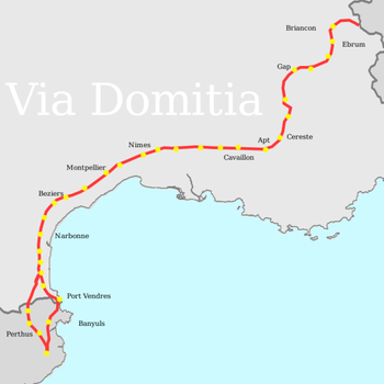
The Via Domitia crossed the Alps at Col de Montgenèvre ( 1850 m ), followed the Durance valley , crossed the Rhone at Beaucaire and finally followed the Mediterranean coast to the Pyrenees .
The road ran almost in a straight line on solid ground. In the cities it crossed, it consisted of cobblestones or paving slabs, outside of tamped earth on layers of gravel or crushed stone. At the entrance to the town, it usually crossed a walled wall through a gate or a triumphal arch , as in Nîmes with the Porte d'Auguste or in Glanum with the Arc de Triomphe.
Cities
Cities on the Via Domitia were:
- Susa ( Segusio ),
- Briançon ( Brigantio ),
- Gap ( Vapincum ),
- Embrun ( Eburodunum ),
- Sisteron ( Segustero ),
- Apt ( Apta Julia ),
- Cavaillon ( Cabellio ),
- Tarascon - Beaucaire ( Ugernum ) as a transition over the Rhone ,
- Nîmes ( Nemausus ),
- Béziers ( Baeterris ),
- Narbonne ( Narbo Martius ).
bridges
Roman bridges of the Via Domitia:
- Saint-Thibéry Roman Bridge (near Béziers)
- Pont Ambroix
- Pont Julien
- Pont Serme

