Adamello
| Adamello | ||
|---|---|---|
|
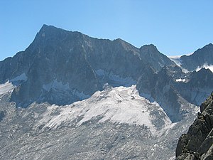
Adamello from the west |
||
| height | 3554 m slm | |
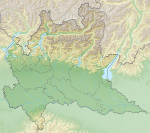
| location | Brescia Province , Lombardy | |
| Mountains | Adamello group | |
| Dominance | 14.8 km → Presanella | |
| Notch height | 670 m ↓ Passo dei Segni | |
| Coordinates | 46 ° 9 '22 " N , 10 ° 29' 47" E | |
|
|
||
| First ascent | September 15, 1864 by Giovanni "Pirinello" Caturani and Julius Payer | |
The Adamello ( 3554 m slm , ital. Cima Adamello or Cima dell'Adamello ) is a dominant peak in northern Italy , about 40 km from Lake Garda and is located in the province of Brescia , not far from the border with Trentino . It is one of the Southern Alps .
Location and surroundings
Together with a few dozen other three-thousand-meter peaks , it forms the huge Adamello group , which measures around 30 km × 30 km and is therefore of a similar area to the Ortler group bordering in the north . About 15 km northeast of the main summit, the massif sinks to the important east-west connection of the Tonale Pass ( Passo del Tonale , 1884 m slm ). A clearly recognizable geological fault line runs along this furrow (see also periadriatic seam ).
The nearby Presanella ( 3556 m slm ) is almost as high as the Adamello .
Some long-distance hiking trails, such as the Adamello Höhenweg (Alta Via dell 'Adamello, part of the Sentiero Italia ), the Sentiero Antonioli and the Bassa Via dell' Adamello, run through the surrounding mountains . These are sometimes wrongly counted as part of the Dolomite high-altitude trails . The group crosses part of the Friedensweg in memory of the bloody fighting in the mountain war of 1915–1918 .
Routes to the summit
Due to its fame as the eponymous mountain of the Adamello group and its not overly difficult climbs, the Adamello is climbed comparatively often. There are routes from every eligible side of the mountain:
The usual route from the east leads from the starting point of Malga Bedole in Val Genova at almost 1600 m asl to the Mandrone hut at 2442 m. From there, a path leads to the tongue of the Mandrone glacier. Over the wide areas of this glacier, the ascent continues in a south-westerly direction and the Corno Bianco circumnavigates on the south side. Finally, the rocky summit structure of the Adamello is climbed along its southeast ridge in a simple climb.
From the north, from the last parking lot in Valle dell'Avio at almost 1600 m slm via hiking trails, the Garibaldi hut at 2550 m slm is reached. From there it goes first west around the reservoir Lago Venerocolo and then in an easterly direction up to Passo Brizio. On the other side of the pass you enter the Mandrone glacier, which you cross in a south-easterly direction until you meet the route that comes from the Mandrone hut. This is where you finally reach the summit.
The usual ascent from the west leads from the Val Malga from the starting point Ponte del Guat to 1528 m slm (free) or Malga Premassone to 1591 m slm (subject to a fee) up to the Gnutti hut at 2166 m slm From here you continue on marked trails up the valley to the start of the Via Terzulli via ferrata. The via ferrata is a bit misleading on this route. There are no continuous safety ropes, chains or step aids. There are double U-shaped hooks as protection, through which one can walk on one's own rope at the same time and before a rope team falls. This secured path takes you to Passo Adamello, crosses the westernmost corner of the Mandrone Glacier to the southeast ridge of the summit structure and follows it as on the other routes to the summit.
The normal route from the south leads from Rifugio Prudenzini at 2235 m slm in the Valle di Salarno over rubble and crags to Passo di Salarno . The open bivouac Bivacco Giannantoni is in the immediate vicinity . From there cross to the northwest over the Pian di Neve and together with the other routes over the rocks of the summit structure to the summit.
All routes are about the same length (2 to 2.5 hours to the respective hut and then 4 to 5 hours to the summit) and are about the same level of difficulty ( WS ).

