Ödenburger Mountains
| Ödenburger Mountains | ||
|---|---|---|
|
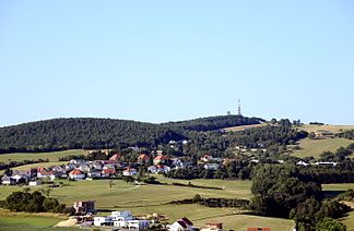
The Brenntenriegel in the municipality of Sieggraben is the highest point in the Ödenburger Mountains |
||
| Highest peak | Brenntenriegel ( 606 m above sea level ) | |
| location | Burgenland , Austria / Hungary border | |
| part of | Edge mountains east of the Mur , Alps | |
|
|
||
| Coordinates | 47 ° 39 ' N , 16 ° 23' E | |
The Ödenburg Mountains ( Hungarian : Soproni-hegység ) are one of the most easterly foothills of the Alps on the Austro - Hungarian border southwest of Sopron (Ödenburg). As a continuation of the Rosaliengebirge , it separates the northern Burgenland from the central Burgenland at the narrowest point in Burgenland . The only two traffic connections between Northern Burgenland and Central Burgenland - Burgenland Straße B50 and Burgenland Schnellstraße S31 - run in the area of the Sieggrabener Saddle , where the Ödenburger Gebirge and Rosaliengebirge meet.
Similar to the Rosaliengebirge, the Ödenburg Mountains consist of gneiss and mica schist , but also - especially in the west - of younger ( neogene ) sediments such as gravel and sands , which can locally also carry hard coal ( Brennbergbánya , Helenenschacht ). The ridge is heavily forested and reaches 606 meters. On the southern slopes of the mountains there are important red wine locations of the Blaufränkischland .
The highest peaks of the Ödenburger Mountains are the 606 meter high Brenntenriegel in the west and the Hohe Riegel (Hungarian Magas-berc , 553 m) directly on the Austrian-Hungarian border. There is an observation tower on it. Another peak is the Angerwald (535 meters), which lies entirely on the Burgenland side.
Web links
- Entry on Ödenburger Gebirge in the Austria Forum (in the AEIOU Austria Lexicon )


