Rosaliengebirge
| Rosaliengebirge | ||
|---|---|---|
|
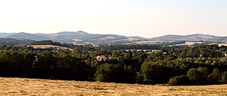
The Rosaliengebirge (here with the Burgberg von Schwarzenbach and the distinctive wooded hilltop of the Sieggrabener Kogel ) extends in the east to the Sieggrabener Sattel |
||
| Highest peak | Heuberg ( Rosalienkapelle ) ( 748 m above sea level ) | |
| location | Lower Austria / Burgenland border , Austria | |
| part of | Edge mountains east of the Mur , Alps | |
| Classification according to | Alpine club division of the Eastern Alps | |
|
|
||
| Coordinates | 47 ° 42 ' N , 16 ° 18' E | |
| rock | Gneiss , mica slate ; above it limestone | |

The Rosaliengebirge ( Hungarian : Rozália-hegység , Croatian Gorje Rozalija ) is a foothill of the Alps on the Lower Austrian - Burgenland border. The Rosaliengebirge rises in its north-south extension near Neudörfl , reaches its highest elevation on the Heuberg (often also referred to as Rosalia ) and then falls back down to Weppersdorf . The Leithagebirge to the north of it is separated by the Wiener Neustädter Pforte .
From a geological point of view, the Rosaliengebirge is part of the Bucklige Welt . The landscape border between the Bucklige Welt and the Rosaliengebirge forms from north to southeast the valley of the Klingfurther Bach , in which the municipality of Klingfurth, which belongs to Walpersbach, and the Hochwolkersdorfer Rotte Rosenbrunn are located. The border then continues over the valley of the Hochwolkersdorfer Rotte Alm , over the so-called Totengraben into the Essengraben and then further over the Graben into the Schwarzenbachtal .
In the east, the Ödenburger Gebirge adjoins the Rosaliengebirge. The border between the two is formed from north to south by the Marzau , the Sieggrabener Sattel and the Sieggrabenbachtal.
The following elevations are located in the northern Rosaliengebirge:
The northern and southern Rosaliengebirge are separated from each other by the Wulkatal , the Heuberg (highest elevation of the Rosaliengebirge near the Rosalienkapelle ) and a ridge that extends from the Heuberg over the Auerberg and the Hochwolkersdorfer Rotte Hollerberg to the Hochwolkersdorfer Rotte Fernblick .
The following elevations are located in the southern Rosalien Mountains:
- Auerberg
- Hartlspitz
- Goat
- Schwarzkogel
- Greimkogel
- Reisnerkogel
- Marriegel
- Sieggrabener Kogel
- Koenigsbühel
- Schwarzenbacher Burgberg
- Red bar
Similar to the Leithagebirge, the Rosaliengebirge consists of gneiss , mica schist and limestone . The ridge is heavily forested. The highest mountain is the Heuberg with the Rosalienkapelle , which reaches a height of 748 m. Also is on him ORF - transmitter Heuberg for northern Burgenland. Forchtenstein Castle is located on the steep limestone cliffs at the eastern foot . The mountains are drained by the Wulka , the Leitha and the Schwarzenbach . Part of the mountain is located in the protected Rosalia-Kogelberg Nature Park .
The Rosaliengebirge can only be crossed by a road from Mattersburg in Burgenland to Hochwolkersdorf in Lower Austria. In the transverse valleys, fruit and wine are widely grown due to the favorable weather . A well-known place is the health resort Bad Sauerbrunn at its northern foot.
literature
- Franz K. Bauer, Rudolph Oberhauser (ed.): The geological structure of Austria. Federal Geological Institute, Springer-Verlag, Vienna / New York 2008, ISBN 3-211-81556-2 , p. 326ff .

