
Sieggraben
|
Sieggraben
|
||
|---|---|---|
| coat of arms | Austria map | |
 |
|
|
| Basic data | ||
| Country: | Austria | |
| State : | Burgenland | |
| Political District : | Mattersburg | |
| License plate : | MA | |
| Surface: | 17.69 km² | |
| Coordinates : | 47 ° 39 ' N , 16 ° 23' E | |
| Height : | 450 m above sea level A. | |
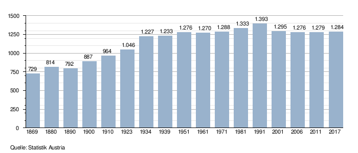
| Residents : | 1,229 (January 1, 2020) | |
| Population density : | 69 inhabitants per km² | |
| Postal code : | 7223 | |
| Community code : | 1 06 13 | |
| NUTS region | AT112 | |
| UN / LOCODE | AT SGR | |
| Address of the municipal administration: |
Sieggraben community 7223 Sieggraben |
|
| Website: | ||
| politics | ||
| Mayor : | Andreas Gradwohl ( SPÖ ) | |
|
Municipal Council : ( 2017 ) (19 members) |
||
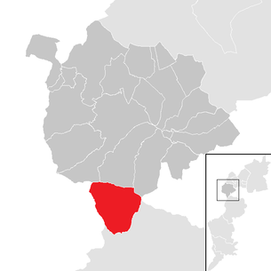
| Location of Sieggraben in the Mattersburg district | ||
  |
||
 Obere Hauptstrasse in Sieggraben |
||
| Source: Municipal data from Statistics Austria | ||


Sieggraben ( Hungarian : Szikra , Croatian : Sigrob ) is a municipality with 1229 inhabitants (as of January 1, 2020) in the Mattersburg district in Burgenland in Austria .
geography
Geographical location
The center of Sieggraben lies in a valley-like depression south of the Sieggrabener saddle , other districts are mostly scattered over hilly area. The Sieggrabener Hügel are offshoots of the Hunchback World . The Sieggrabener Sattel is a prominent geographical point and is formed by the collision of the Rosaliengebirge with the Ödenburger Gebirge . The place is at the narrowest, only four kilometers wide point of the Burgenland . The Sieggrabenbach flows through the municipality, which joins the Schwarzenbach in Weppersdorf and is usually called the Stoober Bach from there . The Brenntenriegel is at 606 m above sea level. A. the highest point in the Ödenburger Mountains. The Sieggrabener Kogel is a striking, widely visible elevation .
Neighboring communities
The community borders on Mattersburg , Marz and Rohrbach bei Mattersburg in the north, in the east at a narrow point on the Hungarian Sopron and Lackenbach in the Oberpullendorf district . In the south lie the places Kalkgruben (as a cadastral community of Weppersdorf ) and Oberpetersdorf (as a cadastral community of Kobersdorf ). In the west is the Lower Austrian town of Schwarzenbach .
The municipal boundaries to the neighboring towns run over long stretches in a wooded area, so that from Sieggraben you can only get directly from Marz via the B 50 and Mattersburg via the S 31 in the north, Kalkgruben, which belongs to Weppersdorf, in the south and the community of Schwarzenbach to the west can reach. From the road to Schwarzenbach a supply road turns off to Oberpetersdorf, which belongs to the municipality of Kobersdorf, in the municipality of Sieggraben .
|
Mattersburg ( District Mattersburg , Bgld.) |
Marz ( District Mattersburg , Bgld.) |
Rohrbach ( District Mattersburg , Bgld.) |
|
Schwarzenbach (Lower Austria) |
.svg)
|
Sopron (Ödenburg, Hungary) |
|
Oberpetersdorf ( District Oberpullendorf , Bgld.) |
Limestone pits ( district Oberpullendorf , Bgld.) |
Lackenbach ( District Oberpullendorf , Bgld.) |
history
A burial ground in the Sieggrabener Bahnwald , which was first mentioned in 1893 by the Hungarian high school teacher and local researcher Lajos Bella from Sopron and was last examined in the summer of 1980, testifies to a settlement in the Bronze Age . In Celtic times the area was part of the Kingdom of Noricum and belonged to the surroundings of the Celtic hill settlement Burg on the Schwarzenbacher Burgberg . In the Roman Empire the area was part of the province of Pannonia . According to the analysis of archaeological finds, the earliest medieval traces of life in Sieggraben go back to the Carolingian period .
The place was first mentioned in 1302 as "Sykrems". It is believed that the place got its name from the stream that flows through the village. In the boundary description of Weppersdorf this brook is mentioned as “Sykrin Potok” (also “Sikrynpotok” and “Scikryn Potok”). The earliest documented evidence of this brook goes back to the year 1222. Subsequently, the spellings “Sigrabn” (1570), “Siggraben” (1641), “Sigroben” (1651), “Szigraben” (1675), “Sigraben” (1682) “Siegraben” (1713) are used for the place names as well as "Siggraben" (1713). The later Magyar name form was Szikra until 1921 .

Sieggraben belonged to the Counts of Mattersdorf-Forchtenstein , later to the Forchtenstein lordship , to the Kobersdorf lordship and finally in 1622 fell into the possession of the Prince of Esterházy . In the manorial arable 16th and 17th centuries, mostly small farmers listed for Sieggraben. In the land register of the County of Forchtenstein from 1675, a school, a community inn and two stone mills are identified for Sieggraben. In the middle of the 17th century the population of Sieggraben was mixed denominationally (Catholic and Protestant), in 1659 the majority was Protestant before it became Catholic around 1660. In 1736 Sieggraben was raised to an independent parish. In the course of the redistribution of the lords of the Prince of Esterházy in 1738, the place came under the rule of Kobersdorf. A fire in 1775 destroyed 30 houses. In 1848 the Hungarian counties were divided into chair districts, whereby the place was allocated to Ödenburg . Another change in the districts in 1870/71 resulted in the Mattersburg district , to which Sieggraben has belonged ever since.
In 1921 the place - like all of today's Burgenland - came to Austria due to the treaties of St. Germain and Trianon from 1919 . Because of the exposed location of the place south of the Sieggrabener Sattel, the Nazi rulers came up with a plan in 1938 to assign Sieggraben to the political district of Oberpullendorf from an administrative point of view. After protests by the local residents of Sieggraben, who asserted that the community was sensibly oriented towards Mattersburg from time immemorial, tended there also in terms of fruit export and the flow of labor and from there also had a convenient rail connection to Vienna, the plan was made dropped. Even after the Second World War , Sieggraben remained a distinct commuter community: in 1951, around 90 weekly commuters from Sieggraben - with a population of 1276 people - commuted to Vienna every Monday.
Population development
Culture and sights

- Catholic parish church Sieggraben : built in 1797, late baroque-Josephinian hall building with polygonal presbytery and street-side tower facade. Interior design: a late baroque hall with a hanging dome over a square floor plan. Extension built 1979/80 with abstract, brightly colored glass painting by Hannelore Knittler-Gsellmann.
- Elementary school: Built between 1926 and 1929 by the architects Franz Kaym and Alfons Hetmanek (both were pupils of Otto Wagner ). At the time of its construction, the Sieggraben primary school was considered to be one of the most beautiful school buildings in Burgenland. On the upper floor there are still original equipment elements from the construction period: ceiling painting (starry sky with constellations) and double doors with painted wooden panels (four elements with four seasons) based on a design by the Free Academic Workshop Vienna.
- Holy Trinity Column: Erected in 1897 at the junction between Hauptstraße and Riegel.
- Village fountain: built in 1998, 2.40 meters high, artistically designed by Friedrich Rosner.
- Brenntenriegel mobile radio and directional radio transmitter : The transmitter is located on the highest elevation of the Ödenburger mountains, the Brenntenriegel.
nature
- Natural areas in Sieggraben: forest-covered mountain tops, Ödenburger mountains, Rosaliengebirge, species-rich flora and fauna, many excursion destinations, since 1999 nature trail with 10 stations
- Rosalia-Kogelberg Nature Park: 7770 hectares, officially established as a nature park by the state government in 2006, Sieggraben is one of the 13 nature park communities
- The Eastern Austrian Grenzlandweg and the European long-distance hiking trail E4 lead through Sieggraben .
politics
Municipal council
The council comprises a total of 19 seats due to the number of inhabitants.
| Political party | 2017 | 2012 | 2007 | 2002 | 1997 | 1992 | 1987 | 1982 | ||||||||||||||||
|---|---|---|---|---|---|---|---|---|---|---|---|---|---|---|---|---|---|---|---|---|---|---|---|---|
| Sti. | % | M. | Sti. | % | M. | Sti. | % | M. | Sti. | % | M. | Sti. | % | M. | Sti. | % | M. | Sti. | % | M. | Sti. | % | M. | |
| ÖVP | 422 | 45.23 | 9 | 530 | 58.11 | 12 | 535 | 56.32 | 11 | 492 | 54.13 | 11 | 474 | 57.95 | 11 | 431 | 51.80 | 10 | 542 | 58.85 | 9 | 452 | 53.24 | 8th |
| SPÖ | 442 | 47.37 | 9 | 348 | 38.16 | 7th | 369 | 38.84 | 8th | 373 | 41.03 | 8th | 344 | 42.05 | 8th | 401 | 48.20 | 9 | 379 | 41.15 | 6th | 397 | 46.76 | 7th |
| ZS | 69 | 7.40 | 1 | not running | not running | not running | not running | not running | not running | not running | ||||||||||||||
| FPÖ | not running | 34 | 3.73 | 0 | 46 | 4.84 | 0 | 44 | 4.84 | 0 | not running | not running | not running | not running | ||||||||||
| Eligible voters | 1147 | 1164 | 1175 | 1134 | 1068 | not raised | not raised | not raised | ||||||||||||||||
| voter turnout | 88.40% | 87.37% | 88.60% | 88.98% | 93.54% | not raised | not raised | not raised | ||||||||||||||||
Parish council

In addition to Mayor Andreas Gradwohl (SPÖ) and Deputy Mayor Andreas Bauer (ÖVP), the executive councils Gerhard Bauer (ÖVP), Anton Kollerits (SPÖ) and Inge Pehm (SPÖ) belong to the community board.
mayor
Andreas Gradwohl (SPÖ) has been mayor since the 2017 municipal council and mayoral election, who in the direct election was 51.58% compared to the previous incumbent Vinzenz Jobst (ÖVP), who was in office for 25 years and this time only 43.13 % brought, prevailed.
Deputy Mayor is Andreas Bauer (ÖVP).
The office manager is Birgit Fürsatz.
Chronicle of the mayor
|
|
|
|||||||||||||||||||||||||||||||||||||||||||||||||||||||||||||||||||||||||||||||||||||||||||||||||||||||||||||||||||||
coat of arms
|
|
Blazon : Three green firs growing in a silver shield on a green three-hill covered with a silver paddle wheel, the middle one with five branch heights (four whorls and tops ), the two lateral (smaller) with four branch heights (three whorls and tops). The symbols used in the community seal since the 17th century (three fir trees growing out of a mountain of three) are reminiscent of the logging that has been relevant for centuries in the economic life of the community and of the charcoal-burning operation that has existed in the village since ancient times. The paddle wheel (mill wheel) is a talking symbol, it refers to the southern district of Mühlviertel. In a figurative sense, the mill wheel can also be understood as a symbol for the commercial economy established in the area. The right to use this coat of arms was granted on September 14, 1983 by the Burgenland state government. |
Personalities
.jpg)
Sons and daughters of the church
- Anton Friedl (* 1958), process engineer and university lecturer
Honorary citizen of the community
- Engelbert Dollfuß (1892–1934) - Austrian politician, founder of the Austro-Fascist corporate state
- On the way to becoming an authoritarian corporate state , the Patriotic Front endeavored in the course of political disputes to establish Chancellor Dollfuss as the great Austrian leader. One of the ways to achieve this goal was to make him an honorary citizen in as many Austrian municipalities as possible. In Sieggraben, Dollfuss was awarded honorary citizenship on May 6, 1934, shortly before his murder on July 25, 1934.
- Otto Habsburg-Lothringen (1912–2011) - 1916 to 1918 Crown Prince of Austria-Hungary , journalist, former member of the European Parliament for the CSU , journalist and writer, 1922 to 2006 head of the Habsburg-Lothringen family
- After the municipality of Ampass in Tyrol granted him honorary citizenship on December 6, 1931, a further 1602 Austrian municipalities, including Sieggraben, followed this example until Austria was annexed to Hitler's Germany in 1938. The honorary citizenship was awarded to partially make up for the unjust action taken against the ruling family from the point of view of the community. On May 6, 1934, Otto Habsburg-Lothringen, who was in exile, was made an honorary citizen not only in Sieggraben, but in all communities in Burgenland.
- Thomas van der Haude - 42 years pastor in Sieggraben
- Rudolf Komjati - primary school director, choir director and conductor
- Johanna Steiner, b. Höttinger - elementary school teacher
- Paul Steiner - primary school director
- Dominikus Werfring - Mayor from 1955 to 1967
- Georg Fuchs - community doctor
- Josef Prieler - 23 years pastor in Sieggraben
- Rupert Löschnauer - elementary school director and multifunctional
- Johann Plank - Mayor from 1967 to 1984
- Willibald Schuh - Mayor from 1984 to 1992
- Vinzenz Jobst - Mayor from 1992 to 2017
Honorary ring bearer of the community
- Albert Taschner - The longtime SPÖ Vice Mayor (1967–1985) was presented with the community's ring of honor in 1993.
- Günter Engelbrecht - Secretary of Governor Theodor Kery , then head of the social department at the Burgenland Provincial Government, from 1994 district captain in Mattersburg.
- Herbert Riegler - long-time chairman of the music association and in many ways active in the local community
- Manfred Grandits - 22 years pastor in Sieggraben (1997 to 2019)
Honor bearer of the community
- Martha Reisner - Head of the Sieggraben municipal office from 1989 to 2019
People related to the community

- The first verifiable ancestors of Ignaz Semmelweis , namely Jörg Semmelweis and his wife Kunigunde, lived in Sieggraben in the second half of the 17th century.
- The Austrian Federal President Thomas Klestil , to whom the community was connected in a special way, received an invitation in Sieggraben on September 6, 2009 at Dr. Thomas Klestil-Platz is a monument with a bronze bust. Already during his lifetime, the community had given him the doctorate on the basis of his services to the state and the town of Sieggraben, following a unanimous decision by the local council. Dedicated to Thomas Klestil-Platz. This was opened on May 17, 2002 in the course of the celebrations for the first documentary mention of Sieggraben. Federal President Thomas Klestil and his wife Margot Klestil-Löffler took part in the celebrations and the opening of the square.
literature
- Sieggraben 1302–2002 , Festschrift for the 700th anniversary of the Sieggraben community, ed. by the community of Sieggraben, Strichpunkt Verlag, Hornstein and Ebreichsdorf 2002.
- Margarete Kaus: The Middle Bronze Age barrows of Sieggraben-Bahnwald. In: Scientific work from Burgenland . Issue 69, Eisenstadt 1984, pp. 43-54.
- Ernst Probst: The barrow culture in Austria . With drawings by Friederike Hilscher-Ehlert, Grin-Verlag, Munich 2011, ISBN 978-3-656-08552-2 , p. 49f.
- Ernst Probst: Austria in the Middle Bronze Age , Grin Verlag, Munich 2011, ISBN 978-3-656-00127-0 , p. 66.
- Erik Szameit: Carolingian weapon finds from Austria , Part II: The Saxe and lance tips. In: Archaeologia Austriaca 71, Vienna 1987, pp. 155–171.
- Josef Köller: The county of Forchtenstein with special consideration of the land register. Diss. Phil., Vienna 1960.
- Andrew Frank Burghardt: The Political Geography of Burgenland , Washington, DC 1958 (= National Academy of Sciences-National Research Council, Publication 587), pp. 211f.
- 200 years parish church for the Exaltation of the Cross in Sieggraben 1797–1997 , ed. from the parish of Sieggraben, Sieggraben 1997.
- J. Kromel, M. Putiš, P. Bačík: The Middle Austro-Alpine Sieggraben structural complex - new data on geothermobarometry , Acta Geologica Slovaca, 3 (1), 2011, 1-12.
- Johannes Heinzle: Investigations on the correlation between mineral content and shear parameters using the example of phyllite from Sieggrabener Sattel , Dipl.-Arb., University of Natural Resources and Life Sciences, Vienna 2003.
- Gernot Enzinger: Documentation and computational analysis of the flood event from June 26th to 27th, 2008 at the Schwarzenbach, Sieggrabenbach and Stooberbach in Central Burgenland , Dipl.-Arb., University of Natural Resources and Life Sciences, Vienna 2009.
- Natalie Stanke: Municipal biomass district heating supply. A guide for processing using the example of Sieggraben; Chronology of an innovative community project , Dipl. Arb., FH-Stg. Building technology, Pinkafeld 1999.
gallery

Interior view of the Catholic parish church for the Exaltation of the Cross in Sieggraben

Trinity Column

Sieggrabener Kogel (wooded hilltop), in the foreground the tower of the Roman Catholic parish church Kobersdorf
Hill from left to right: Schwarzenbacher Burgberg with the observation tower, Sieggrabener Kogel , Sieggrabener Sattel and Brenntenriegel

The Brenntenriegel with the transmitter, on the left the wooded Stadelberg, in front of it the Sieggraben district of Anger

Brenntenriegel mobile and directional radio transmitters
.jpg)


Web links
- Sieggraben community
- Sieggraben on atlas-burgenland.at
- 10613 - Sieggraben. Community data, Statistics Austria .
- Municipal boundaries with neighboring municipalities
- Municipal boundaries at the gentleman's table
Individual evidence
- ↑ Of the originally around 30 hills in the Sieggraben burial ground from the Bronze Age burial mounds, only 14 flat elevations remain. By the 1930s, the hills had been increasingly leveled as the forest in which they were located was turned into arable land. The route of the Burgenland expressway S31 was laid through the former burial ground from 1980 to 1984 . To mark the occasion, a few mounds were examined in 1980, and body and cremations were found. Cf. Ernst Probst: The tumulus culture in Austria . With drawings by Friederike Hilscher-Ehlert, Grin-Verlag, Munich 2011, ISBN 978-3-656-08552-2 , p. 49f.
- ^ Ernst Probst: Austria in the Middle Bronze Age , Grin Verlag, Munich 2011, ISBN 978-3-656-00127-0 , p. 66.
- ↑ Josef Tiefenbach (Ed.): Historischer Atlas Burgenland (= scientific work from Burgenland, 141). Burgenland State Museum publishing house, Eisenstadt 2011, ISBN 978-3-85405-185-5 , p. 54.
- ↑ Sieggraben 1302-2002 , Festschrift for the 700th anniversary of the municipality Sieggraben, ed. from the community of Sieggraben, Strichpunkt Verlag, Hornstein and Ebreichsdorf 2002, p. 23.
- ↑ a b Erhard Kranzmayer and Karl Bürger: Burgenland settlement name book (= Burgenland research, edited by the state archive and state museum, issue 36), Eisenstadt 1957, p. 143f.
- ^ Austriae Ducatus Seu Pannoniae Superioris Chorographia Germana , plan by Wolfgang Lazius , 1570
- ↑ To this day there is a mill wheel in the municipal coat of arms of Sieggraben.
- ↑ Cf. Josef Köller: The Grafschaft Forchtenstein with special consideration of the land register. Diss. Phil., Vienna 1960, pp. 132f. and p. 153ff.
- ↑ At the time of the canonical visitation in 1641 Sieggraben belonged to the parish of Marz. See Hans Paul: On the history of elementary schools in Burgenland-West Hungary from the 17th century to 1921, Office of the Burgenland State Government, Eisenstadt 1999 (= Burgenland Research, Vol. 78), ISBN 978-3-901517-15-0 , p 146.
- ↑ 200 years of the parish church for the Exaltation of the Cross in Sieggraben 1797–1997 , ed. from the parish of Sieggraben, Siegrraben 1997, p. 12.
- ↑ Hans Krawarik: Exul Austriacus. Confessional migration from Austria in the early modern period , Lit Verlag, Vienna 2010, ISBN 978-3-643-50210-0 , p. 97.
- ↑ Sieggraben 1302-2002 , Festschrift for the 700th anniversary of the municipality Sieggraben, ed. from the community of Sieggraben, Strichpunkt Verlag, Hornstein and Ebreichsdorf 2002, p. 174.
- ↑ 200 years of the parish church for the Exaltation of the Cross in Sieggraben 1797–1997 , ed. from the parish of Sieggraben, Siegrraben 1997, p. 13.
- ^ Andrew Frank Burghardt: The Political Geography of Burgenland , Washington, DC 1958 (= National Academy of Sciences-National Research Council, Publication 587), pp. 211f.
- ↑ Andrew Frank Burghardt: The Political Geography of Burgenland , Washington, DC 1958 (= National Academy of Sciences-National Research Council, Publication 587), p. 212, note 66.
- ^ Election result of the 2017 municipal council election in Sieggraben. Office of the Burgenland Provincial Government, October 29, 2017, accessed on January 17, 2020 .
- ↑ Results of the 2012 municipal council elections in Sieggraben. Office of the Burgenland Provincial Government, November 4, 2012, accessed on January 17, 2020 .
- ↑ Result of the 2007 municipal council elections in Sieggraben. Office of the Burgenland Provincial Government, October 21, 2007, accessed on January 17, 2020 .
- ↑ a b Results of the 2002 municipal council elections in Sieggraben. Office of the Provincial Government of Burgenland, October 21, 2002, accessed on January 17, 2020 .
- ↑ a b c Sieggraben 1302–2002 , Festschrift for the 700th anniversary of the Sieggraben community, ed. from the community of Sieggraben, Strichpunkt Verlag, Hornstein and Ebreichsdorf 2002, pp. 106-107
- ↑ a b Municipality of Sieggraben: The Municipal Council (accessed on November 27, 2017)
- ↑ Province of Burgenland: Sieggraben 2017 election results (accessed on November 27, 2017)
- ^ Sieggraben municipality: municipal administration (accessed on November 27, 2017)
- ↑ a b c Sieggraben 1302–2002 , Festschrift for the 700th anniversary of the Sieggraben community, ed. from the community of Sieggraben, Strichpunkt Verlag, Hornstein and Ebreichsdorf 2002, p. 43.
- ↑ ÖVP loses the mayor's chair in Sieggraben Article on mein district.at, online version from October 2, 2017
- ↑ Sieggraben on atlas-burgenland.at
- ^ The mayors of the ÖVP Sieggraben on oevp-sieggraben.at
- ↑ "GWP" stands for "Community Economic Party", cf. atlas-burgenland.at
- ↑ In the commemorative publication for the 700th anniversary of the Sieggraben community, Josef Schuh is not explicitly identified as a member of the NSDAP, but it is obvious that he was a party member. After the war he worked again as a gravedigger in the community. See Sieggraben 1302–2002 , Festschrift for the 700th anniversary of the Sieggraben community, ed. from the community of Sieggraben, Strichpunkt Verlag, Hornstein and Ebreichsdorf 2002, p. 114f.
- ↑ Martin Schuh was appointed mayor by the Soviet occupying power, cf. atlas-burgenland.at
- ↑ Sieggraben 1302-2002 , Festschrift for the 700th anniversary of the municipality Sieggraben, ed. from the community of Sieggraben, Strichpunkt Verlag, Hornstein and Ebreichsdorf 2002, p. 15.
- ↑ Sieggraben 1302-2002 , Festschrift for the 700th anniversary of the municipality Sieggraben, ed. from the community of Sieggraben, Strichpunkt Verlag, Hornstein and Ebreichsdorf 2002, p. 126ff.
- ↑ a b honorary citizen and honorary ring bearer on sieggraben.at
- ↑ Ernst Hanisch : Politics and Agriculture. In: Franz Ledermüller (Ed.): History of Austrian Agriculture and Forestry in the 20th Century , Volume 1: Politics, Society, Economy, Ueberreuter Verlag, Vienna 2002, ISBN 3-8000-3859-5 , p. 126.
- ↑ Honorary Citizen Dr. Engelbert Dollfuss on sieggraben.at
- ↑ The Mayor of Ampass, Josef Kaltenbrunner, had read in September 1931 in the “Volkszeitung”, an organ of the Tyrolean Socialists, that Otto's return was to be expected soon, since 50 communities had made him an honorary citizen. Kaltenbrunner liked this, and on December 6, 1931, the Ampass municipal council granted Otto Habsburg-Lothringen honorary citizenship. What Kaltenbrunner did not know, however, was that the report in the “Volkszeitung” was an invention of the socialists in order to use it to carry out propaganda against Otto. See Stephan Baier and Eva Demmerle: Otto von Habsburg. The biography. With a greeting from Pope Benedict XVI., 5th edition, Amalthea Verlag, Vienna 2002, ISBN 978-3-85002-486-0 , p. 109.
- ↑ Honorary Citizen Otto von Habsburg-Lothringen on sieggraben.at
- ↑ Vinzenz Jobst is an honorary citizen of the Sieggraben community. In: Community news Sieggraben No. 78, December 2017, pp. 1 and 5.
- ↑ Sieggraben 1302-2002 , Festschrift for the 700th anniversary of the municipality Sieggraben, ed. from the community of Sieggraben, Strichpunkt Verlag, Hornstein and Ebreichsdorf 2002, pp. 129–130.
- ↑ a b Well-deserved honors for office director and pastor . In: Sieggrabener Nachrichten 02/2019, p. 15.
- ↑ "On September 16, 1692 the Erbare Jenggesöll Jörg Semmelweis was copulated (= married) with the virtue seed virgin Kunygundt", as noted in the parish register. See Thomas Dormandy: Moments of Truth. Four Creators of Modern Medicine Publisher: Wiley, Chichester 2003, ISBN 0-470-86321-8 , pp. 137f.
- ↑ Károly Kapronczay: The Semmelweis family. Cultural transfer, multilingualism and civic development ( Memento of the original from February 26, 2014 in the Internet Archive ) Info: The archive link was inserted automatically and has not yet been checked. Please check the original and archive link according to the instructions and then remove this notice. . In: András F. Balogh (Ed.): Multilingualism in Central Europe. On the history of a literary and cultural opportunity, Praesens Verlag, Vienna 2012, p. 117.
- ↑ Unveiling of the Dr. Thomas Klestil bust in Sieggraben. In: Article on sieggraben.at. Retrieved March 4, 2012 .
- ↑ 700 years of Sieggraben - ceremony on May 17th, 2002 . In: Community portrait on sieggraben.at . Retrieved October 4, 2015.
Antau | Bad Sauerbrunn | Baumgarten | Draßburg | Forchtenstein | Hirm | Krensdorf | Loipersbach in Burgenland | March | Mattersburg | Neudörfl | Pöttelsdorf | Pöttsching | Rohrbach near Mattersburg | Schattendorf | Sieggraben | Sigleß | Meadows | Zemendorf-Stöttera
Cadastral communities: Sieggraben
Location: Sieggraben
Village: Sieggraben Rotte: Mühlviertel • Riegel Scattered houses: Sieggraben forest
Counting district: Sieggraben