Burning bars
| Burning bars | ||
|---|---|---|
|
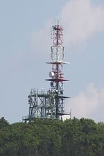
The Brenntenriegel with the transmitter, on the left the wooded Stadelberg, in front of it the Sieggraben district of Anger |
||
| height | 606 m above sea level A. | |
| location | Burgenland , Austria | |
| Mountains | Ödenburger Mountains | |
| Dominance | 1.9 km → Sieggrabener Kogel | |
| Notch height | 109 m ↓ Sieggraben | |
| Coordinates | 47 ° 39 '34 " N , 16 ° 23' 26" E | |
|
|
||
| rock | Sedimentary rock | |
| Normal way | From the south | |
The Brenntenriegel , also known as Brentenriegel ( Hungarian : Bren-tető ), is a mountain in Burgenland ( Austria ). At 606 m above sea level A. it is the highest point in the Ödenburger Mountains .
The Brenntenriegel is about one kilometer northeast of the village of Sieggraben , about 25 km southwest of Eisenstadt . While the north and west of the mountain are forested, the south and east are characterized by orchards. Several forest roads and hiking trails lead to the Brenntenriegel. There is a 40 meter high BEWAG transmitter on the mountain . There is also a small private observatory here , as the mountain is particularly suitable for astronomical observations.
Geologically, the Brenntenriegel is made up of sediments (especially gravel ), which mainly consist of rubble of quartzite and granite gneiss .
Individual evidence
- ↑ according to the Federal Office for Metrology and Surveying
- ↑ Archive link ( Memento of the original dated December 7, 2010 in the Internet Archive ) Info: The archive link was inserted automatically and has not yet been checked. Please check the original and archive link according to the instructions and then remove this notice.
- ↑ http://burgenland.astronomie.at/orte/br.htm
- ↑ http://www.uibk.ac.at/downloads/oegg/Band_24_38_133.pdf


