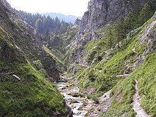
Ötscher-Tormäuer Nature Park
The Ötscher-Tormäuer nature park is located in the southern Mostviertel in the districts of Scheibbs and Lilienfeld .
The nature park extends over the municipal areas of Gaming , Lackenhof (municipality of Gaming), Puchenstuben , Sankt Anton an der Jeßnitz , Annaberg and Mitterbach am Erlaufsee (the last two in the Lilienfeld district ). At 170 km², the park is the largest of the 22 nature parks in Lower Austria .
To preserve the nature park and its pathways, an entrance fee is required at the entrances. The area north and northwest of the nature park is called Ötscherland . There is a cycle route of the same name there.
History of origin
The nature park was created in 1970 as a result of a protest movement against another hydropower plant on the Erlauf , which was to be built between Trübenbach and Gaming , after an equalization basin had already been built in the Tormäuern with the Wienerbruck power plant and the Erlaufboden power plant . In 1970 the Ötscher-Tormäuer Nature Park Association was founded with the aim of preserving the white water route.
Natural sights

The specialty of the nature park are its deeply cut valleys of the Erlauf (Vordere and Hintere Tormäuer) and the Ötscherbach ( Ötschergräben ) as well as its mountain peak regions ( Ötscher and Gemeindealpe ) with numerous alpine pastures . Other natural sights are numerous waterfalls ( Mirafall , Schleierfall , Trefflingfall and Lassingfall ), the Erlaufsee , the Erlaufstausee and the karst caves ( Ötscher stalactite cave , Taubenloch and Geldloch).
The flora is typical for the region of the Northern Limestone Alps, including rare plant species such as B. Daphne , orchid or gentians .
Built sights
In Wienerbruck (municipality of Annaberg), at the entrance to the Ötschergräben , a new nature park center was built directly on the Wienerbruck reservoir in close cooperation with the Lower Austrian State Exhibition 2015. The Ötscher base houses a restaurant with a lake terrace and is the starting point for many hikes. 70 trained nature educators offer various guided hikes.
In the municipality of Mitterbach, the stack house is located on the Erlaufstausee as an entrance to the nature park and as a tavern. There is also a nature trail and in Trübenbach (municipality of Puchenstuben) an educational stone trail and a lumberjack museum. A planetary path was also built in Puchenstuben.
On the alpine pasture at Hochbärneck in St. Anton an der Jeßnitz there is an alpine house, a lookout point and an observatory .
The Ötscher (up to the Ötscherschutzhaus ) and the Gemeindealpe can be reached by chairlifts in summer and winter. The Terzerhaus on the Gemeindealpe offers a refreshment stop.
The Vorderötscher shelter at the end of the Ötschergräben was renovated in 2015. There are 20 beds and 20 beds in the camp.
A dense network of marked hiking trails has been set up throughout the nature park.
See also
Web links
- Ötscher-Tormäuer Nature Park of the Ötscher-Tormäuer Nature Park
- Ötscher-Tormäuer Nature Park Mostviertel.at - hiking tours, starting points, visitor information
- Ötscher-Tormäuer Nature Park run by the Lower Austria Nature Park Association
- Ötscher-Tormäuer Nature Park in the web site of the Association of Nature Parks of Austria
- World Database on Protected Areas - Ötscher-Tormäuer Nature Park (English)
Individual evidence
- ↑ Ötscherland cycle route - cycling. Retrieved July 30, 2019 .
-
↑ Bernhard Gamsjäger: Puchenstuben community . 2004.
The treasures of the Vaterberg. The history of the Ötscher and the Ötscher-Tormäuer nature park . In: naturpark-oetscher.at . Ötscher-Tormäuer GmbH Nature Park, accessed and received on August 16, 2016.
Coordinates: 47 ° 52 ' N , 15 ° 14' E


