
Trefflingfall
| Trefflingfall | ||
|---|---|---|
 Cascades |
||
| Coordinates | 47 ° 54 '34 " N , 15 ° 13' 37" E | |
|
||
| place | Municipality Puchenstuben , District Scheibbs , Lower Austria | |
| height | 100 m | |
| Number of fall levels | several | |
| flow | Trefflingbach → Erlauf | |

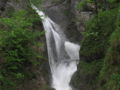
The Trefflingfall is located in a gorge in the municipality of Puchenstuben in the federal state of Lower Austria and is one of the longest waterfalls in the state. The gorge is formed by the Trefflingbach, a small tributary of the Erlauf . The Trefflingbach rises at the foot of the 1246 m high Turmkogel. The Trefflingfall is located in the Ötscher-Tormäuer nature park and is also one of the attractions of the nature park.
Origin, history, use
The actual gorge with the waterfall falling over several cascades is about 280 meters long, the difference in height is about 100 meters, with the individual cascades having a maximum drop of 20 meters. Immediately after the last cascade, the stream flows into the Erlauf. The gorge runs from northeast to southwest. The underground of the gorge consists of limestone . A well-developed and popular hiking trail leads through the gorge. The entrance to the gorge can only be reached on foot and is located 2000 meters east of the parking lot on the cul-de-sac from Gaming and 1600 meters southwest of the street from Puchenstuben .
In 1897 the way to the Trefflingfall was opened. This was built by the Scheibbser Mountain Association.
Web links
- MeinBezirk.at (Trefflingfall - Ötscher Tormäuer Nature Park)
- dirndltal360.at (Trefflingfall 360 ° virtual tour)
hikes
Individual evidence
- ↑ Mitteilungen, Volumes 23-24, Deutscher Alpenverein 1897.

Trefflingfall, cascades from above
Treffling case, detail

