
Ötscher
| Ötscher | ||
|---|---|---|
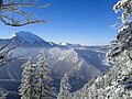
 Ötscher, view from Annaberg (15 km east) |
||
| height | 1893 m above sea level A. | |
| location | Lower Austria , Austria | |
| Mountains |
Ybbstal Alps ( AVE ) Lassingalpen ( Trimmel ) |
|
| Dominance | 21.8 km → Herbalist | |
| Notch height | 821 m ↓ Zeller saddle | |
| Coordinates | 47 ° 51 '42 " N , 15 ° 12' 8" E | |
|
||
| rock | Banked Dachstein limestone | |
| Age of the rock | 220 Ma ( Upper Triassic ) | |
| Normal way | West ridge (not difficult ) | |
 View from the summit with a fixed point for trigonometric measurements and a summit cross towards the south. |
||

The Ötscher is a 1893 meter high, dominating mountain range in southwestern Lower Austria . The Ötscher region belongs to the Northern Limestone Alps - in particular the Ybbstaler Alps - and is one of their easternmost high mountain ranges. The border between the districts of Lilienfeld and Scheibbs runs directly above the summit . The Ötscher is the landmark of the Mostviertel and its highest peak .
The main summit, 1893 m above sea level. A. and officially called Ötscher , is sometimes also called Großer Ötscher .
On the Ötscher plateau there is still the 1849 m high Taubenstein and around two kilometers southwest of the Ötscher summit the 1552 m high Kleiner Ötscher .
The mountain range is located in the Ötscher-Tormäuer nature park .
Surname
The around 400 BC Celts who immigrated to the area gave the dominant mountain of the region the name ocàn ("father mountain"), from which the name Ötscher (<slav. * Otьčanъ 'godfather') arose under later Slavic influence .
Location and landscape


Due to its isolated position, the mountain is visible from 100 km away. From the north it appears massive and wide, but from the west and especially the east you can see its narrow side. The limestone is cut all around by deep valleys and gorges, so that it is only accessible from the northwest. Therefore there are only two larger towns within a radius of 20 km: the district capital Scheibbs in the north and Mariazell in the southeast.

Boundary and summit of the Ötscher area
In a broader sense, the Ötscher area, locally also called Ötscherland , includes the mountains between Neubruck bei Scheibbs, Lunz am See and Mariazell.
The more precise delimitation takes place according to the mountain group structure for the Austrian cave directory of Trimmel , where the Ötscher has the number 1816, as follows:
- in the north-west: Ois (Ybbs) near Meierhöfen (bridge approx. 440 m ) - Lackenbach - Lackenhof - Raneck ( 954 m ) - Ortleitengraben - Nestelberggraben - Erlauf at the Vorderen Tormäuern (bridge 444 m above sea level ) to the Ybbstaler Voralpen ( No. 1820; Gföhleralm-Polzberg 1824)
- in the northeast and east: Erlauf upwards (Tormäuer) - Mitterbach am Erlaufsee - Weißenbach (Mariazell station 851 m ) - Rasing ( 768 m ) to the Türnitz Alps (No. 1830; mountainous region between Erlauf and Pielach 1836 to Erlaufboden , Koller – Büchleralpe 1833 to the Erlaufstausee , then Bürgeralpe 1831)
- in the south: Rasing - Grünaubach - Zellerrain ( 1125 m ) - Neuhauser Bach - confluence with the Ois to the Zellerhüten (No. 1813)
- in the southwest of Ois (Ybbs) to Meierhöfen (approx. 655 m ) to Dürrenstein (No. 1815)
The Ötscher massif includes in this sense
- the main summit, the [Great] Ötscher ( 1893 m above sea level )
- the south-western side summit Kleine Ötscher ( 1552 m above sea level ) with the lifts of the small ski area
- the ridge south of the Ötschergräben over Eiserner Herrgott ( 1409 m above sea level ) to the Gemeindealpe ( 1626 m above sea level ), with the cable car from Mariazell to the Terzer Haus
- the rear gate walls on the Erlauf near Wienerbruck on the Mariazeller Bahn in the east
- and the north roof towards the front gate walls, with the Nestelberg ( 1057 m above sea level )
In a broader sense, the Ötscher region also includes
- the area Gföhler Almspitze ( 1110 m above sea level ), Rainstock ( 1296 m above sea level ) with the Ötscher stalactite cave and Polzberg ( 1066 m above sea level ) near Gaming
- and the mountains north of the Erlauf to the Jessnitz and the area around Puchenstuben , which still belong to the nature park, but are generally counted as part of the Türnitz Alps. These are in particular Hochreithspitz ( 835 m above sea level ) and Haigerkogel ( 855 m above sea level ) above Grafenmühl on the Erlauf in the west, Turmkogel ( 1130 m above sea level ) with the Vorderen Tormäuern as the south flank, and Turmkogel / Brandmäuer ( 1277 m above sea level / 1246 m above sea level ) in the east.
The Ötscher region thus adjoins the Eisenwurzen to the southeast , but is now also mentioned as part of it.
Caves on and next to the Ötscher
The most famous Ötscher caves are the Geldloch, Taubenloch and Pfannloch directly below the Rauhen Kamm, as well as the Ötscher stalactite cave located about five kilometers north of the Ötscher summit .
Money hole

The entrance to the cave with the cadastral number 1816/6 is on the east side of the Ötscher summit at the foot of the Rauhen Kamm at an altitude of around 1460 m. It was researched as early as 1592 at the instigation of Emperor Rudolf II . As of 1983, a total length of 6678 meters and a total height difference of 535 meters (+101, −434) was known. The Austria lexicon are with stand 1995 at a length of 9047 meters and a vertical extent of 653 meters.
Pigeon hole
The entrance to the cave with the cadastral number 1816/14 is on the east side of the Ötscher summit at the foot of the Rauhe Kamm at an altitude of around 1505 m and around 400 meters north-northeast of the entrance to the moneyhole. As of 1981 a total length of 1462 meters and a total height difference of 413 meters (+21, −392) was known. As of 1995, the Austrian Lexicon indicates a length of 4131 meters and a vertical extension of 514 meters.
nature
The gate walls and Ötschergräben represent a system of gorges that surround the mountain range on three sides. In this "Grand Canyon of Lower Austria" the tributaries and the main river Erlauf itself - 1500 meters below the summit - flow to the east, then to the north and west. This is why the eastern ridge of the Ötscher, the Rauhe Kamm , is the steepest ( difficulty I ).
The Ötscher area is one of the few areas in Austria in which brown bears have recently been found over a longer period of time (1972–2011).
tourism

Lackenhof am Ötscher (810 m) is the most famous winter sports resort in Ötscherland. From the end of the village, a double chair lift leads to the Ötscherschutzhaus , which is located at an altitude of 1410 m, a little below the western ridge. Here the main path leads to the summit, which is known for its good views.
Picture gallery

Ötscher south side
View of the Ötscher from the Turmkogel

The Rauhe Kamm (facing northeast)

Summit cross on the Ötscher

Ötschergraben

Ötscherbach with footbridge at Ötscherhias


.JPG)


literature
- Werner Tippelt: The Ötscher . Radinger Print, Scheibbs, 2nd edition 2002, ISBN 3-900974-00-4
- Alexander Tollmann : Geology of the limestone foothills in the Ötscherland as an example of alpine tectonics. In: Mitteilungen der Geologische Gesellschaft in Wien, Volume 58, 1965, pp. 103–207 ( pdf , uibk.ac.at)
- Werner Bätzing , Hannes Hoffert-Hösl: The Ötscher - Hikes in the Lower Austrian Limestone Alps. Rotpunktverlag, Zurich 2015, ISBN 978-3-85869-651-9
- Werner Gamerith : Ötscherland: Experience nature between farmland and mountain wilderness. Tyrolia-Verlag, Innsbruck 2009, ISBN 978-3-7022-3044-9
Web links
Individual evidence
- ↑ a b Ötscher in the ÖK , for local naming see the website of the Ötscher-Schutzhaus ( memento from April 26, 2015 in the Internet Archive ), Austrian Tourist Club
- ^ Association of Austrian cave researchers (ed.): Mountain group structure for the Austrian cave directory and for the cave directory of the Bavarian Alps. Vienna (68 sheets unpaginated, 1 map 1: 500,000). ; Lukas Plan: Verbal description of the delimitation of the subgroups of the Austrian cave directory . Status: Jan 08 2008. Ed .: Association of Austrian Speleologists. ( pdf , hoehle.org [accessed on September 6, 2017] entry under “Ybbstaler Alps”).
- ↑ See the labeling of the ÖK200 or other Austrian reference map series, such as the Konzenn School Atlas
- ^ Österreich-Lexikon , Vienna 1995, Volume 2, Page 166 (Online: [1] )
- ↑ The Geldloch am Ötscher in Lower Austria: The history of exploration of a cave as reflected in four centuries ; accessed on January 13, 2014
- ↑ The Neuforschungen in the pigeon hole on the Oetscher (Lower Austria) ; accessed on January 13, 2014
- ↑ WWF Austria : Distribution of brown bears in Austria and Europe. Retrieved August 13, 2020.