Herbalist
| Herbalist | ||
|---|---|---|
|
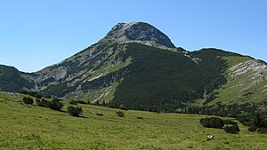
The Hochstadl, the highest peak of the herb woman, seen from the northeast. |
||
| height | 1919 m above sea level A. | |
| location | Styria , Austria | |
| Mountains | Ybbstal Alps , Northern Limestone Alps | |
| Dominance | 4.5 km → Riegerin | |
| Notch height | 1072 m ↓ northwest. Mariazell | |
| Coordinates | 47 ° 41 ′ 8 " N , 15 ° 4 ′ 30" E | |
|
|
||
| rock | Dachstein limestone , main dolomite | |
| Age of the rock | Triad | |
The herb is a subordinate, approx. 10 km × 12 km large mountain range in the Ybbstal Alps and reaches a summit height of 1919 m above sea level with the Hochstadl . A.
The mountain massif is located in the north of Styria , near the border with Lower Austria and is bordered in the northwest by the Göstling Alps (especially by the Dürrenstein ), in the east by the Mariazeller mountains ( Großer Zellerhut , 1639 m ) and to the south by the Salza . This deeply cut, winding valley separates the herbalist from the Hochschwab group , which is similar in shape . The historic Eisenstrasse (today's B24 ) and the second Viennese mountain spring pipeline run through the Salzatal .
There are marked climbs to the Kräuterin from Rotmoos near Weichselboden in the east and from Dürradmer in the northeast. The higher peaks are relatively rugged (the second highest is the Fadenkamp at 1804 m ), but there are extensive alpine meadows between them .
The 7 km long, north-south oriented main ridge ends in the north in the thread wall ( 1420 m ), which drops steeply to the Rothwald am Dürrenstein, a particularly strict nature reserve. Also in the south, at the foot of the west and south walls of the Kräuterspitze ( 1726 m ), Kleinem Hochstadl ( 1838 m ) and Ilmlahn , there is a protected area that extends down the valley to the Wildalpen and Weichselboden .
In the east of the main ridge there is a diverse mountainous area, which extends from the Hochtürnach ( 1770 m ) over the Tannberg ( 1509 m ) and its Rotmoos to the Dürradmer (800–820 m), the widely ramified, alpine-covered valley head of the Radmerbach between three 1440 m high mountains. The northernmost of these (Schwarzenberg, 1426 m ) is, however, already included in the mountain range of the three Zeller hats.
The Warwas-Glatzen cave system in the Kräuterin has a length of over 10.7 km and a depth of 765 m and descents up to 30 m in height. The cave system is described as winding, there are ice locks and floods. On October 30, 2017, a 48-year-old Czech cave explorer fell in the cave and was killed.
Individual evidence
- ↑ Accident in cave: Czech scientists dead. In: orf.at . October 31, 2017, accessed August 17, 2020 .

