Dürrenstein (Ybbstal Alps)
| Dürrenstein | ||
|---|---|---|
|
View from the Gemeindealpe to the Dürrenstein |
||
| height | 1878 m above sea level A. | |
| location | Lower Austria , Austria | |
| Mountains | Ybbstal Alps , Northern Limestone Alps | |
| Dominance | 11.2 km → Hochstadl | |
| Notch height | 809 m ↓ Bärenrisssattel | |
| Coordinates | 47 ° 47 '8 " N , 15 ° 3' 34" E | |
|
|
||
| Type | Plateau mountain | |
| rock | Dachstein Limestone | |
| Age of the rock | Upper Triassic | |
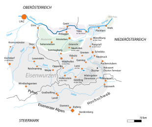
The Dürrenstein is an 1878 m above sea level. A. high mountain massif in southwestern Lower Austria. It is the third highest peak in the Ybbstal Alps and after the Ötscher the highest mountain in the Mostviertel . The wide limestone massif is located south of Lunz am See in the Lower Austrian-Styrian border area. It is shaped similarly to the Ötscher (1893 m) about 20 km to the east.
Surroundings
Lunzer See , Mittersee and Obersee are three different ice age lakes. The Mittersee has an extreme flow rate and many springs and only has around 7 ° C all year round. At the Obersee you will find beautiful fens and swinging lawns .
In some sinkholes on the Dürrenstein plateau, extremely low night temperatures were measured in the past. For this reason, during the Second World War there was also a Wehrmacht test station in the Grünloch sinkhole , which is regarded as the cold pole of Austria or even Central Europe , where vehicle engines were tested for their suitability for warfare in Siberia . Some heavily rusted relics from that time can still be seen there today. On February 19, 1932, a temperature of −52.6 degrees Celsius was measured in this sinkhole.
The Rothwald southeast of the Dürrenstein is considered to be the last primeval forest in Austria, but is not accessible. It is part of the Dürrenstein wilderness area , one of the largest preserved primeval forest areas in Central Europe.
Routes
- Ascent to the summit via Ybbstaler Hütte from Steinbach, Stiegengraben or Lechnergraben
- Tagles or Seetal via Herrenalm to the summit
geology
Geologically, the Dürrenstein belongs to the Northern Limestone Alps . Tectonically , the Dürrenstein summit and the Dürrenstein plateau belong to the Ötscher Nappe . Most of the Dürrenstein plateau as well as the summit are made up of Dachstein limestone and Dachstein dolomite from the Upper Triassic . Ramsaudolomit and Lunzer layers of the Middle Triassic can be found on the northwestern and southwestern slopes . In the northern area of the massif there are two small deposits of Cretaceous Gosau sediments, in this area it is fossil-rich sandstone. In the area around the Obersee, sediments from the Jura have been deposited: These are the Obersee breccia and Hierlatz Limestone . Numerous karst phenomena such as sinkholes or karst bowls can be observed on the Dürrenstein plateau . In addition, there are Augenstein gravel in many places on the Dürrenstein plateau .
See also
Web links
- Stefan Eisenbach: Hochkar – Dürrenstein Alpine Trail. In: eisenbach.at.
swell
- ↑ Manfred Dorninger: The Green Hole: On the trail of the natural phenomenon of the sinkhole. (pdf; 1.9 MB) Institute for Meteorology and Geophysics, University of Vienna, November 29, 2003, archived from the original on June 4, 2011 ; accessed on August 17, 2020 (talk).
- ^ Geological map of the Republic of Austria 1: 50,000. Published by the Federal Geological Institute, Vienna 1988, sheet 71 Ybbsitz.


