
Ötscherbach
| Ötscherbach | ||
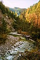
 Ötscherbach next to the Ötscherhias snack bar |
||
| Data | ||
| location | Ötscher , Ybbstal Alps , Lower Austria | |
| River system | Danube | |
| Drain over | Erlauf → Danube → Black Sea | |
| source | Türndlmäuer on the southwest slope of the Ötscher 47 ° 50 ′ 50 ″ N , 15 ° 10 ′ 24 ″ E |
|
| Source height | approx. 1100 m above sea level A. | |
| muzzle | on the Stierwaschboden in the Erlauf coordinates: 47 ° 50 '58 " N , 15 ° 17' 17" E 47 ° 50 '58 " N , 15 ° 17' 17" E |
|
| Mouth height | 622 m above sea level A. | |
| Height difference | approx. 478 m | |
| Bottom slope | approx. 53 ‰ | |
| length | approx. 9 km | |
| Catchment area | 38.2 km² | |
| Communities | Mitterbach am Erlaufsee | |
The Ötscherbach is an approximately nine kilometers long left tributary of the Erlauf in the Ybbstal Alps in the municipality of Mitterbach am Erlaufsee in Lower Austria and is located in the Ötscher-Tormäuer Nature Park . From the Schleierfall - around three kilometers after the source - the stream flows in the so-called Ötschergraben.
Ötscherbach
The stream rises at an altitude of around 1100 meters near the Türndlmäuern on the south-western slope of the Ötscher and flows into the Erlauf at a height of around 640 m and around 500 meters in front of the Wienerbruck power station on Stierwaschboden. The river flows strictly from west to east and drains an area of a good 38 km², which includes the southern part of the Ötscher and the northern part of the Gemeindealpe .
Ötschergraben, Schleierfall, Mirafall
The Ötschergraben is a deeply cut, gorge-like ditch with a length of about six kilometers and extends from the Schleierfall ( 47 ° 50 ′ 28 ″ N , 15 ° 13 ′ 7 ″ E ) to the Stierwaschboden (Wienerbruck power plant). The plural is often used as the designation, whereby between the Vorderen Ötschergraben , the area between the Stierwaschboden and the Ötscherhias Jausenstation ( 47 ° 50 ′ 37 ″ N , 15 ° 14 ′ 57 ″ E ) , and the Rear Ötschergraben with the Schleier- and Mirafall ( 47 ° 50 ′ 40 ″ N , 15 ° 15 ′ 45 ″ E ) .
ways
A well-developed and well-traveled hiking trail leads through the moat. About halfway there is the Ötscherhias snack station , from which a hiking trail branches off towards the Erlaufstausee . At the end of the Ötschergräben, directly between the Gemeindealpe and Ötscher, is the Vorderötscher shelter, where you can also stay overnight. The gorge can only be reached on foot either from Lackenhof via the Riffelsattel , or via the Ötscher summit and the descent via the Rauen Kamm , or from Wienerbruck (train station of the Mariazellerbahn ) through the Lassinggraben . Another option is from the Erlaufboden through the rear gate walls.
Picture gallery
The Ötscherbach in autumn, near the head of the Ötschergraben

The Schleierfall at the beginning of the Ötschergraben

The Mirafall between the Schleierfall and the snack station

The Ötscherbach just before it joins the Erlauf

The Ötscherbach at the top of the trench


Web links
Individual evidence
- ↑ BMLFUW (Hrsg.): Area directory of the river areas: Danube area from the Enns to the Leitha. In: Contributions to Austria's Hydrography Issue 62, Vienna 2014, p. 36. PDF download , accessed on July 8, 2018.
- ^ Franz Hauleitner: Ötscher: Mariazell, Türnitz, Traisentaler Berge . 4th edition, Bergverlag Rother, Munich 2010.