
Göschenen
| Göschenen | |
|---|---|
 |
|
| State : |
|
| Canton : |
|
| District : | No district division |
| BFS no. : | 1208 |
| Postal code : | 6487 |
| Coordinates : | 687 832 / 169146 |
| Height : | 1102 m above sea level M. |
| Height range : | 992–3629 m above sea level M. |
| Area : | 104.15 km² |
| Residents: | 448 (December 31, 2018) |
| Population density : | 4 inhabitants per km² |
|
Proportion of foreigners : (residents without citizenship ) |
15.6% (December 31, 2,014) |
| Mayor : | Felix Cavaletti |
| Website: | www.goeschenen.ch |
 Göschenen |
|
| Location of the municipality | |
  |
|
Göschenen ( Rhaeto-Romanic ) is a municipality in the Reuss valley in the canton of Uri in Switzerland .
geography
Geographical location
The village of Göschenen is located in the upper Reuss valley. In addition to the village, the municipality also includes the hamlets Abfrutt ( 1168 m ), Wiggen ( 1318 m ) and Gwüest ( 1582 m ) in the Göschenertal.
Waters

The former settlement of Göscheneralp , nine kilometers west of the village, has disappeared in the Göscheneralpsee reservoir . Its residents moved to Gwüest.
The Alper Reuss and the Voralpreuss , which flow through the Voralptal, come together at the Wiggen Alpine settlement . From then on, the river bears the name Göschenerreuss and flows into the Reuss below the village .
area
Only 1% of the municipality is settlement area, half of which is traffic area. With 759 hectares, the agricultural area only accounts for 7% of which are primarily the alpine areas in Göschenertal with 689 hectares. Only 70 hectares are meadow and arable land. In addition to 11% forest, the unproductive area comprises most of the municipal area, a total of 8,372 ha or 80.4%. It concerns almost exclusively areas with little or no vegetation in the high mountains.
On the right of the Reuss, the very steep Riental belongs to the municipality of Göschenen. It is bounded in the east by the mountain range of Schijenstock , Bächenstock and Rienzenstock . The almost impassable Rientalalp can be reached via a steep mountain path that leads over the mountain ridge to the Oberalp from Andermatt .
The Göscheneralptal is developed for alpine hikes. Five refuge huts and a bivouac of the Swiss Alpine Club SAC are located in the municipality of Göschenen: the Salbit , the Voralp , the Chelenalphütte, the Bergsee and the Dammahütte , the first two of which have been linked by the Salbitbrücke for alpine hikers since 2010 .
neighborhood
Göschenen borders in the west on the mountain range of the Winterberg with the Dammastock on the Valais municipality of Obergoms and the Bernese Oberland municipality of Gadmen , in the north on Wassen , in the east on Gurtnellen and in the south on Andermatt , Hospental and Realp .
population
| year | Residents |
|---|---|
| 1837 | 344 |
| 1850 | 348 |
| 1880 | 2992 |
| 1888 | 703 |
| 1920 | 974 |
| 1930 | 860 |
| 1941 | 850 |
| 1950 | 698 |
| 1960 | 1284 |
| 1970 | 888 |
| 1980 | 708 |
| 1990 | 585 |
| 2000 | 511 |
| 2005 | 473 |
| 2010 | 428 |
The population stagnated between 1837 and 1850. Because it belonged to the municipality of Wassen (until 1875), there are no more population data until 1880. The record number of 1880 is due to the presence of numerous construction workers on the Gotthard Railway . This is also the reason for the considerable decline in population up to 1888. As a result of the connection to the rail network, there was a growth of almost 40% between 1888 and 1920.
In the 1920s there was a sharp decline in population (1920–1930: −11.3%), followed by a decade of stagnation. Another surge of emigration followed in the 1940s (1941–1950: −17.9%), primarily to the Urner Unterland. The high population of 1960 can be explained by the presence of numerous construction workers for the Göscheneralp Reservoir. After all, this building led to a considerable increase in population (1950–1970: +27.2%), so that Göschenen had more inhabitants in 1970 than in 1941. Since then, the number of residents has been falling; between 1970 and 2005 the population halved.
languages
The population speaks a highly Alemannic dialect. Almost the entire population speaks German as the everyday language. At the last census in 2000, 95% said German, 2% Portuguese and 1% Spanish were their main languages.
Religions - denominations
The population used to be fully members of the Roman Catholic Church. The denominational relationships in 2000 still show the original structure. 452 people were Catholic (88.45%). In addition, there were 4% Evangelical Reformed Christians and 4% non-denominational. 14 people did not provide any information about their creed.
Origin - nationality
Of the 473 residents at the end of 2005, 440 (93%) were Swiss citizens. The majority of the immigrants come from Central Europe (Germany, Liechtenstein and Austria), from Southern Europe (Italy, Portugal and Spain) and from Iceland and Brazil. At the 2000 census, 483 people (94%) were Swiss citizens; fifteen of them had dual citizenship.
age structure
The community has a high proportion of older residents. The proportion of people under the age of twenty of 21% of the population is significantly below the proportion of people of senior age (60 years and older: 26.42%).
| Age | 0–6 years | 7-15 years | 16-19 years | 20-29 years | 30–44 years | 45–59 years | 60–79 years | ≥ 80 years |
|---|---|---|---|---|---|---|---|---|
| number | 28 | 57 | 22nd | 56 | 111 | 102 | 115 | 20th |
| proportion of | 5.48% | 11.15% | 4.31% | 10.96% | 21.72% | 19.96% | 22.50% | 3.91% |
politics
Legislature
The municipal assembly forms the legislature . It usually meets twice a year.
Executive
The five-member municipal council forms the executive . Mayor Felix cavaletti (as of 2017).
Economy and Infrastructure
economy
In 2005 there were 10 farms offering 34 jobs. Industry and trade employed 75 people in 4 workplaces, the service sector in 17 companies 96 people (employment converted to full-time positions). The 2000 census showed 12 agricultural and forestry businesses with 35 employees. The 2001 business census came to 6 industrial and commercial enterprises with 109 and 23 service companies with 121 employees. Of Göschenen's 268 gainfully employed people in 2000, 143 (53%) worked in their own community. In total, the place offered work to 243 people, of whom 143 (59%) were locals.
Most of the 125 commuters do their work in other municipalities in the canton of Uri. Including 34 people in Altdorf, 30 in Andermatt, 12 each in Erstfeld and Wassen, 7 in Schattdorf and 5 in Silenen. But there were also 100 commuters. These came mainly from Silenen (20 people), Wassen (14), Andermatt (12), Altdorf and Schattdorf (10 each), Erstfeld and Gurtnellen (9 each).
Energy generation
About eight kilometers west of the village of Göschenen in the Göschenerreuss valley lies the Göscheneralp reservoir , which is used to generate energy in the Göschenen power station . There is also a small power station in the community.
traffic
Transit traffic
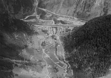
The north portal of the Gotthard tunnel , which was built between 1872 and 1882 for the Gotthard Railway , is located in Göschen's municipality .
In 1980 the Gotthard road tunnel was opened, which also has its north portal here.
Göschenen has a train station on the Gotthard route and a junction with the Gotthard motorway . The narrow valley in front of the tunnels is therefore used entirely for traffic structures.
Schöllenenbahn
The station Göschenen is also the starting point of the Schöllenenbahn the MGB , a meter-gauge cog railway up to Andermatt in Urserental . The route leads through the steep Reuss valley with the Schöllenenschlucht , past the historic Devil's Bridge and the Urnerloch .
Local roads
The cantonal road from Flüelen and Altdorf to the Gotthard Pass crosses the village from the toll bridge , which is secured with an old gate, to the steep ascent into the Schöllenenschlucht, where the old mule track on the Häderlis bridge crossed the Reuss.
Attractions
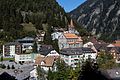
Göschenen village

Primary school building

reformed Church

Monument tunnel construction

Devil stone
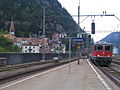
Göschenen seen from the train station

Station with Gotthard tunnel portals

Göschenen
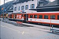
typical shuttle train of the Matterhorn-Gotthard-Bahn on the station forecourt of Göschenen

116 m long visor tunnel for the construction of the Gotthard tunnel from 1872 (open to the public)

Göschenen at the end of the 19th century


Personalities
- Ernst Zahn (1867–1952), writer, hotelier in Göschenen from 1900 to 1916
- Louis Favre (1826–1879), engineer, died in Göschenen in 1879 while working on the Gotthard tunnel
See also
literature
- Thomas Brunner: The art monuments of the canton Uri, Volume 4: Upper Reuss Valley and Urseren. Edited by the Society for Swiss Art History GSK. Bern 2008 (Art Monuments of Switzerland Volume 114). ISBN 978-3-906131-89-4 . Pp. 237-285.
Web links
- Official website of the community of Göschenen
- Hans Stadler: Göschenen. In: Historical Lexicon of Switzerland .
Individual evidence
- ↑ Permanent and non-permanent resident population by year, canton, district, municipality, population type and gender (permanent resident population). In: bfs. admin.ch . Federal Statistical Office (FSO), August 31, 2019, accessed on December 22, 2019 .
- ↑ pxweb.bfs.admin.ch
Altdorf | Andermatt | Attinghausen | Build | Bürglen | Erstfeld | Flüelen | Göschenen | Belt pins | Hospental | Isenthal | Realp | Schattdorf | Seedorf | Seelisberg | Silenen | Sisikon | Spiringen | Undercuts | Water
Canton of Uri | Districts of the canton Uri | Municipalities of the Canton of Uri