Sisikon
| Sisikon | |
|---|---|
| State : |
|
| Canton : |
|
| District : | No district division |
| BFS no. : | 1217 |
| Postal code : | 6452 |
| Coordinates : | 690016 / 200 556 |
| Height : | 453 m above sea level M. |
| Height range : | 434–2460 m above sea level M. |
| Area : | 16.45 km² |
| Residents: | 369 (December 31, 2018) |
| Population density : | 22 inhabitants per km² |
|
Proportion of foreigners : (residents without citizenship ) |
16.4% (December 31, 2,014) |
| Mayor : | Timotheus Abegg |
| Website: | www.sisikon.ch |
|
Old view of Sisikon, before 1914 |
|
| Location of the municipality | |
Sisikon is a municipality in the canton of Uri in Switzerland .

geography
Sisikon is located on the east bank of the Urnersee on the delta of the Riemenstaldnerbach . In the north Sisikon borders on the Schwyz communities Morschach and Riemenstalden , in the south on the Uri communities Flüelen and Bürglen .
The village is dominated by striking foothills of the Alps : the Fronalpstock in the northeast and the Kaiserstock chain in the southeast with the outermost summit Rophaien above Sisikon. To the west, the view from the village is open over the lake to the glacier pyramid of the Urirotstock , to the mountains above the lake such as the Oberbauenstock , to the villages of Bauen and Seelisberg and to the clearing settlement Rütli .
Thanks to the mild climate, figs and kiwis thrive in Sisikon .
Only 20 hectares or 1.2% of the municipality is settlement area. Of this, 8 hectares are building areas and 10 hectares are traffic areas. The agricultural area is more extensive with 504 hectares or a share of 30.9%. Underneath are large alpine areas that cover an area of 428 hectares. In contrast, there are only 73 hectares of meadow and arable land. 717 hectares or 44.0% are covered by forest and woodland. The rest of the parish area, 388 hectares or 23.8%, is unproductive area. It concerns almost exclusively areas without vegetation (high mountains) or areas with unproductive vegetation (high alpine vegetation).
population
| Population development | |
|---|---|
| year | Residents |
| 1850 | 245 |
| 1860 | 197 |
| 1870 | 243 |
| 1880 | 841 |
| 1888 | 291 |
| 1900 | 274 |
| 1920 | 340 |
| 1930 | 318 |
| 1941 | 435 |
| 1950 | 335 |
| 1960 | 336 |
| 1970 | 309 |
| 1990 | 319 |
| 2000 | 350 |
| 2010 | 393 |
The first wave of emigration occurred in the 1850s, but this was made up for in the following decade. The record number of 841 residents in 1880 is due to the construction of the Gotthard railway line. Overall, the rail connection led to a population increase (1870–1888: + 19.8%). Thereafter, there was a slight decline in the number of residents until the turn of the century. Between 1900 and 1941 the population grew strongly (1900–1941: +58.8%). In the 1940s there was a second wave of emigration (1941–1950: −23.0%). In the 1950s the number of residents remained stable. Between 1960 and 1970 some of the inhabitants emigrated again. In total, Sisikon lost 126 inhabitants (or 29.0%) between 1941 and 1970. Since then, steady growth has started. It was moderate between 1970 and 1990, and has been strong since then (1970–2005: +26.2%).
languages
The population speaks a highly Alemannic dialect. Almost the entire population speaks German as the everyday language. In the last census in 2000, 96.00% said German, 1.43% Italian and 1.14% Serbo-Croatian as their main language.
Religions - denominations
The population used to consist entirely of members of the Roman Catholic Church. The denominational relationships in 2000 still show the original structure. 306 people were Catholic (87.43%). In addition, there were 5.43% Evangelical Reformed and 3.14% Orthodox Christians and 1.71% non-religious. Eight people (2.29%) did not provide any information about their creed.
Origin - nationality
At the end of 2018, 289 (78.10%) of the 370 residents were Swiss nationals. The majority of the immigrants come from Central Europe (Austria, the Netherlands and Germany), the former Yugoslavia, Latvia and Sri Lanka. At the 2000 census, 318 people (90.86%) were Swiss citizens; 15 of them had dual citizenship.
age structure
The community has a high proportion of younger residents. The proportion of people under the age of twenty of 27.14% of the local population is significantly higher than the proportion of people of senior age (60 years and older; 18%). This is due to the population growth since 1970. The immigration of young people has led to more births, so that the population is (statistically) younger.
The last census in 2000 showed the following age structure:
| Age | 0–6 years | 7-15 years | 16-19 years | 20-29 years | 30–44 years | 45–59 years | 60–79 years | 80 years and more |
| number | 29 | 50 | 16 | 52 | 78 | 62 | 51 | 12 |
| proportion of | 8.29% | 14.29% | 4.57% | 14.86% | 22.29% | 17.71% | 14.57% | 3.43% |
politics
legislative branch
The municipal assembly forms the legislature. It usually meets twice a year.
executive
The seven-member municipal council forms the executive. He works part-time. The current mayor is Timotheus Abegg (as of 2017).
economy
In 2005 there were 12 farms offering 24 jobs. Industry and trade employed 11 people in 4 workplaces, the service sector in 16 companies 90 people (employment converted to full-time positions). The 2000 census showed 10 agricultural and forestry businesses with 30 employees. The 2001 business census came to 6 industrial and commercial enterprises with 16 and 19 service companies with 80 employees. Of the 181 employed persons of Sisikon in 2000, only 66 (36.46%) worked in their own municipality. In total, the place offered work to 105 people, of whom 66 (62.86%) were locals.
The 115 commuters do their work in other municipalities in the canton of Uri, but also in larger numbers outside the canton of residence. Including 22 people in Altdorf and 6 each in Schattdorf, Erstfeld and Bürglen. Important places of work outside the canton were the Schwyz municipalities of Schwyz (23 people), Arth (8) and Ingenbohl (6) as well as the city of Lucerne (6) and the city of Zug (4). There were only 39 commuters. These came mainly from Altdorf (9 people), Schattdorf (7), Ingenbohl (5) and the municipality of Schwyz, Morschach (Canton Schwyz) and Flüelen (3 each).
traffic
Two main arteries cut through the village: the Gotthard railway line and the A4 national road , better known as the Axenstrasse . The two traffic routes are both a curse and a blessing for the village: on the one hand, they ensure excellent connections to the rest of the world, on the other hand, the village is plagued by noise , exhaust fumes and a high risk of accidents .
Building history: The opening of the Gotthard Pass road in 1830 brought a sharp increase in traffic across the Alps. It was precisely at this time that the steamship age began on Lake Lucerne . So all loads and passengers from Brunnen and Lucerne were transported across the lake. Soon this cumbersome form of transport was no longer sufficient for goods traffic, which is why ever louder voices demanded the construction of a road from Brunnen via Sisikon to Flüelen . Construction work began in 1862, in 1864 the first section of the plant called Axenstrasse was inaugurated, and in 1865 it was open to traffic.
In 1871, with the founding of the Gotthard Railway Company, the course was set for further opening up Sisikon. This culminated in 1882 with the ceremonial opening of the Axen route .
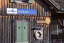
A side road branches off from Sisikon to Riemenstalden , where postbuses go. Scheduled ships of the Lake Lucerne Shipping Company serve the Sisikon and Tellsplatte stations several times a day , from where a cable car goes up the Ax.
history
The name Sisikon was first documented in a letter of protection from Beromünster Abbey from 1173 as "an estate in Sysinchon". The name indicates Alemannic settlers during the early medieval immigration period between the 5th and 9th centuries. The name is probably derived from "Siso" and means court of the Sisinge . Siso could be the abbreviation of a name like Sigisbert or Sigismund. The fact that much earlier Celts and Gallo- Romans lived on Lake Uri for a while is believed to be possible based on the names of the places and fields.
The Riemenstalderbach, which runs through Sisikon, has repeatedly led to natural disasters for centuries . The village was also hit by large rockfalls, as in 1801 when a rock wall 300 meters long and 250 meters high fell into the lake, causing a huge tidal wave that killed 14 people in Siskon.
Attractions
- Parish Church of St. Joseph
- The Tell Chapel is located on the lake shore in the Sisikon municipality, three kilometers south of the village .
- The largest carillon in Switzerland has stood above the chapel since 2001, which sounds popular folk songs every hour on the hour.
- The tallest baobab tree north of the Alps is located at the nearby Tellsplatte restaurant .
Excursions and sports
With its location on the Swiss Path , Sisikon is a starting point for hikes around Lake Uri . Further excursions lead to the surrounding mountain peaks on foot or by ski touring . The Rophaien offers a spectacular view of Lake Uri and the mountains around the Urirotstock.
The Alplersee (also Alplensee) is located around 10 kilometers southeast of Sisikon. It can only be reached on foot, either from Riemenstalden via Chäppeliberg and Alplen, or from the Butzen and Stock Alps.
Sisikon is popular among windsurfers because Lake Uri offers the best thermal conditions here. Advanced skiers enjoy the opportunity to dash across the lake at high speed with a foehn or bise .
literature
- Helmi Gasser : The art monuments of the canton Uri, Volume 2: The lakeside communities. Edited by the Society for Swiss Art History GSK. Bern 1986 (Art Monuments of Switzerland Volume 78). ISBN 3-7643-1811-2 . Pp. 1-60.
Web links
- Official website of the municipality of Sisikon
- Hans Stadler: Sisikon. In: Historical Lexicon of Switzerland .
Individual evidence
- ↑ Permanent and non-permanent resident population by year, canton, district, municipality, population type and gender (permanent resident population). In: bfs. admin.ch . Federal Statistical Office (FSO), August 31, 2019, accessed on December 22, 2019 .
- ^ Federal Statistical Office
- ↑ Spilau cable car


