
Santa Comba Dão
| Santa Comba Dão | ||||||
|---|---|---|---|---|---|---|
|
||||||
| Basic data | ||||||
| Region : | Centro | |||||
| Sub-region : | Dão-Lafoes | |||||
| District : | Viseu | |||||
| Concelho : | Santa Comba Dão | |||||
| Coordinates : | 40 ° 24 ′ N , 8 ° 8 ′ W | |||||
| Residents: | 3392 (as of June 30, 2011) | |||||
| Surface: | 11.84 km² (as of January 1, 2010) | |||||
| Population density : | 286 inhabitants per km² | |||||
| Postal code : | 3440 | |||||
| politics | ||||||
| Address of the municipal administration: | Junta de Freguesia de Santa Comba Dão Largo Dr. António Oliveira Salazar, nº 8 3440-340 Santa Comba Dão |
|||||
| Santa Comba Dão district | ||||||
|
||||||
| Residents: | 11,597 (as of June 30, 2011) | |||||
| Surface: | 111.95 km² (as of January 1, 2010) | |||||
| Population density : | 104 inhabitants per km² | |||||
| Number of municipalities : | 6th | |||||
| administration | ||||||
| Administration address: | Câmara Municipal de Santa Comba Dão Largo do Município 13 3440-337 Santa Comba Dão |
|||||
| President of the Câmara Municipal: | João António de Sousa Pais Lourenço ( PSD ) | |||||
| Website: | www.cm-santacombadao.pt | |||||


Santa Comba Dão is a city in Portugal , about 270 km northeast of Lisbon . It has 3392 inhabitants (as of June 30, 2011). Santa Comba Dão is known for the former primeiro-ministro and dictator António de Oliveira Salazar , who was born in the municipality of Vimieiro in 1889 and lived there after his term in office in 1968 until his death in 1970.
history
The place was first mentioned in 974 AD. Santa Comba Dão received its first town charter ( Foral ) in 1102 in order to promote the repopulation after the destruction caused by the Reconquista . King Manuel I renewed the town charter in 1514. The current district was created through incorporations in 1836, 1837 and 1895.

administration
circle
Santa Comba Dão is the seat of a district of the same name ( concelho ) in the district of Viseu . On June 30, 2011, the district had 11,597 inhabitants on an area of 112 km².
The neighboring areas are (starting clockwise in the north): Tondela , Carregal do Sal , Tábua , Penacova , and Mortágua .
With the regional reform in September 2013 , several municipalities were combined into new municipalities, so that the number of municipalities decreased from nine to six.
The following municipalities ( Freguesias ) are in the Santa Comba Dão district:

| local community | Population (2011) |
Area km² |
Density of population / km² |
LAU code |
|---|---|---|---|---|
| Ovoa e Vimieiro | 1,640 | 22.47 | 73 | 181410 |
| Pinheiro de Ázere | 937 | 11.89 | 79 | 181403 |
| Santa Comba Dão e Couto do Mosteiro | 4,572 | 26.74 | 171 | 181411 |
| Sao Joaninho | 1,075 | 9.72 | 111 | 181405 |
| São João de Areias | 1.939 | 21.51 | 90 | 181406 |
| Treixedo e Nagozela | 1,434 | 19.62 | 73 | 181412 |
| Santa Comba Dão district | 11,597 | 111.95 | 104 | 1814 |

Population development
| Population of the Santa Comba Dão district (1801–2011) | |||||||||
|---|---|---|---|---|---|---|---|---|---|
| 1801 | 1849 | 1900 | 1930 | 1960 | 1981 | 1991 | 2001 | 2011 | |
| 893 | 6,089 | 12,237 | 14,088 | 13,723 | 14,099 | 12,209 | 12,473 | 11,661 | |
Municipal holiday
- Ascension of Christ
Town twinning
-
 Mozambique : Namaacha ( Maputo Province ) since 1998

Worth seeing
Among the numerous architectural monuments, the baroque church Igreja da Misericórdia de Santa Comba Dão , built in 1737 , the Mannerist- Baroque mansion Casa dos Arcos with its Rococo chapel, and the historic town center with its originally from the 17th century should be mentioned in particular Buildings from the 16th to 20th centuries.
Salazar's birthplace is located in the district of Vimieiro . This is not publicly accessible.

sons and daughters of the town
- José da Silva Carvalho (1782–1856), politician, multiple minister
- Manuel de Serpa Machado (1784-1858), politician
- Zeferino Norberto Gonçalves Brandão (1842–1910), writer and general
- Maria do Céu da Silva Mendes (1847–1933), pianist and philanthropist
- José Maria de Sousa Horta e Costa (1858–1927), Governor of Macau and Portuguese India
- António de Oliveira Salazar (1889–1970), economist and politician, authoritarian head of state from 1932 to 1968
- Virgílio de Jesus e Silva Escudeiro (1889–?), Engineer and entrepreneur, railway builder in Angola
- António Luís Costa (* 1953), serial killer
- João António de Sousa Pais Lourenço (* 1962), politician and engineer
- João Carlos Amaral Marques Coimbra (* 1986), football player
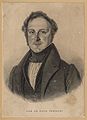
José da Silva Carvalho (engraving from 1834)

Major Zeferino Norberto Gonçalves Brandão 1891
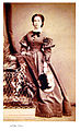
Maria do Céu da Silva Mendes

Dictator Salazar (1940)


Web links
- Map of the Freguesia Santa Comba Dão at the Instituto Geográfico do Exército
- Official website
Individual evidence
- ↑ www.ine.pt - indicator resident population by place of residence and sex; Decennial in the database of the Instituto Nacional de Estatística
- ↑ a b Overview of code assignments from Freguesias on epp.eurostat.ec.europa.eu
- ↑ Address of the Junta de Freguesia ( Memento of the original from June 4, 2010 in the Internet Archive ) Info: The archive link has been inserted automatically and has not yet been checked. Please check the original and archive link according to the instructions and then remove this notice.
- ↑ a b www.ine.pt - indicator resident population by place of residence and sex; Decennial in the database of the Instituto Nacional de Estatística
- ↑ www.cm-santacombadao.pt ( Memento of the original from August 22, 2012 in the Internet Archive ) Info: The archive link was automatically inserted and not yet checked. Please check the original and archive link according to the instructions and then remove this notice. , accessed December 3, 2012
- ^ Publication of the administrative reorganization in the Diário da República gazette of January 28, 2013, accessed on March 16, 2014
- ↑ www.anmp.pt , accessed December 30, 2012
- ↑ www.monumentos.pt , accessed on December 3, 2012
- ↑ ditto
- ↑ ditto
- ↑ Information from the Portuguese Embassy in Germany (as of September 2011)

Armamar | Carregal do Sal | Castro Daire | Cinfães | Lamego | Mangualde | Moimenta da Beira | Mortágua | Nelas | Oliveira de Frades | Penalva do Castelo | Penedono | Resende | Santa Comba Dão | São João da Pesqueira | São Pedro do Sul | Sátão | Sernancelhe | Tabuaço | Tarouca | Tondela | Vila Nova de Paiva | Viseu | Vouzela