
Lamego
| Lamego | ||||||
|---|---|---|---|---|---|---|
|
||||||
| Basic data | ||||||
| Region : | Norte | |||||
| Sub-region : | Douro | |||||
| District : | Viseu | |||||
| Concelho : | Lamego | |||||
| Coordinates : | 41 ° 6 ′ N , 7 ° 49 ′ W | |||||
| Residents: | 26,691 (as of June 30, 2011) | |||||
| Surface: | 165.44 km² (as of January 1, 2010) | |||||
| Population density : | 161 inhabitants per km² | |||||
| Postal code : | 5100 | |||||
| Lamego district | ||||||
|
||||||
| Residents: | 26,691 (as of June 30, 2011) | |||||
| Surface: | 165.44 km² (as of January 1, 2010) | |||||
| Population density : | 161 inhabitants per km² | |||||
| Number of municipalities : | 18th | |||||
| administration | ||||||
| Administration address: | Câmara Municipal de Lamego Av. Padre Alfredo P Teixeira 5100-150 Lamego |
|||||
| President of the Câmara Municipal: | Francisco Manuel Lopes ( PSD ) | |||||
| Website: | www.cm-lamego.pt | |||||


Lamego is a city ( Cidade ) and a district ( concelho ) in the district of Viseu , a few kilometers south of the Douro in northern Portugal . The city is the seat of a Catholic diocese. It is part of the Rede de Judiarias , an association of places with a historically significant Jewish community. It is also part of the Alto Douro wine region , which became the world's first protected wine region in 1756 and which has been a UNESCO World Heritage Site since 2001 .
 |
history

The place was probably originally settled by Celtiberian Turdulians, and also existed in Roman times . When the king of the Visigothic Empire , Rekkared I , converted to Christianity, Lamego also became Christian as a result. Lamego was first mentioned as a bishopric in 570, with its bishop Sardinário. King Sisebut minted coins here until 621 , which underlines the importance of the place at that time.
The Arabs conquered Lamego in the course of their conquest in the 8th century. After the arrival of the Reconquista, the city fell several times to the Christian conquerors and back to the Moors , until Ferdinand I of León finally took Lamego on November 29, 1057. The city did not become a bishopric again until 1071 (see also the list of the bishops of Lamego ). The first king of Portugal, Alfonso I ( Portuguese : D.Afonso Henriques), was solemnly confirmed here in 1143 by the assembly of the Cortes (estates) at Lamego. Alfonso I gave the so-called "Basic Laws of Lamego" (1181) to the new empire and named it "Portugal" after the name of the county of Portocale .
In the years 1191 and 1290 Lamego received further rights, including market rights, which further enhanced the place, and in particular attracted traders with oriental fabrics and spices from large parts of the Iberian Peninsula , such as Castile and the emirate of Granada . In the 15th century, the city benefited particularly from its advantageous location on the country's most important trade routes, but the Portuguese voyages of discovery then diverted the trade routes, with the result that local trade became increasingly less important. In 1514 King Manuel I renewed Lamego's city rights.

During the tenure of Bishop Manuel de Noronha (1551–1564) a lot of building activity began, in particular the place of pilgrimage Santuário de Nossa Senhora dos Remédios is to be mentioned. In the course of the 17th and 18th centuries, a number of mansions were built , which were mainly built by families active in the up-and-coming viticulture. With the law of September 10, 1756, the Marquês de Pombal then created the Companhia Geral da Agricultura das Vinhas do Alto Douro , which received the monopoly over the growing area of the Alto Douro . It was the first protected wine-growing region in the world. As a result, the region continued to grow, from which Lamego also benefited greatly.
In 1835 districts were created as part of an administrative reform. Lamego became the seat of a district, which was moved to Viseu due to its more central location . In the second half of the 19th century, Lamego then underwent a number of urban development measures, which in particular created the wide avenues of today's cityscape.
Attractions
- The shrine of Nossa Senhora dos Remédios , overbuilt by a rococo chapel from 1761, is located on a hill southwest of the city. As an extension of the main street of Lamegos, a 613-step double staircase leads to the pilgrimage chapel.
- The Gothic cathedral in the city (Sè) is the main church of the diocese. It was changed a lot in the 16th and 17th centuries.
- The keep from the 13th century remains of the castle above the town .
- A museum has been set up in the former bishop's palace.
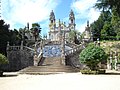
Santuário Nossa Senhora dos Remédios

Lamego Cathedral

The Municipal Museum ( Museu de Lamego )
The Teatro Ribeiro da Conceição
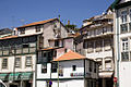
In the historic town center


Lamego district
Lamego is the seat of a district of the same name. The neighboring areas are (starting clockwise in the north): Mesão Frio , Peso da Régua , Armamar , Tarouca , Castro Daire and Resende .
With the regional reform in September 2013, several municipalities were merged into new municipalities, so that the number of municipalities decreased from 24 to 18.
Communities


The following municipalities ( freguesias ) are in the Lamego district:

| local community | Population (2011) |
Area km² |
Density of population / km² |
LAU code |
|---|---|---|---|---|
| Avões | 619 | 4.87 | 127 | 180502 |
| Bigorne, Magueija e Pretarouca | 706 | 20.14 | 35 | 180526 |
| Britiande | 934 | 4.80 | 195 | 180504 |
| Cambres | 2,066 | 11.28 | 183 | 180505 |
| Cepões, Meijinhos e Melcões | 1,071 | 10.96 | 98 | 180527 |
| Ferreirim | 904 | 5.53 | 164 | 180507 |
| Ferreiros de Avoes | 509 | 2.65 | 192 | 180508 |
| Figueira | 342 | 4.55 | 75 | 180509 |
| Lalim | 729 | 7.22 | 101 | 180510 |
| Lamego | 12,214 | 20.20 | 605 | 180525 |
| Lazarim | 521 | 16.54 | 32 | 180511 |
| Parada do Bispo e Valdigem | 1,039 | 12.89 | 81 | 180528 |
| Penajóia | 1,023 | 10.13 | 101 | 180516 |
| Penude | 1,666 | 12.82 | 130 | 180517 |
| Samodães | 203 | 3.09 | 66 | 180519 |
| Sands | 916 | 3.13 | 293 | 180520 |
| Várzea de Abrunhais | 405 | 5.85 | 69 | 180523 |
| Vila Nova de Souto d'El-Rei | 824 | 8.79 | 94 | 180524 |
| Lamego district | 26,691 | 165.44 | 161 | 1805 |
population
| Population development Lamego (1801-2006) | |||||||||
|---|---|---|---|---|---|---|---|---|---|
| 1801 | 1849 | 1900 | 1930 | 1960 | 1981 | 1991 | 2001 | 2004 | 2006 |
| 14,688 | 20,240 | 31,835 | 34,730 | 36,320 | 32,833 | 30.164 | 28,081 | 27,054 | 26,484 |
Town twinning
Sons and daughters
- Jerónimo Cardoso (1508–1569), lexicographer, Latinist, Romanist and Lusitanist
- Marcos Teixeira de Mendonça (1578–1641), Bishop of Salvador da Bahia , figure of resistance against the Dutch
- Fra ′ Manuel Pinto de Fonseca (1681–1773), 68th Grand Master of the Order of Malta
- Francisco Eduardo da Costa (1819–1850), pianist and composer
- Afonso de Castro (1824–1885), governor of Portuguese Timor
- José Augusto Guedes Teixeira (1843–1890), lawyer, entrepreneur and prominent mayor of Lamegos
- José Agostinho de Oliveira (1866–1938), critic, author and dramaturge
- Alfredo Cardoso de Soveral Martins (1869–1938), naval officer and colonial administrator
- Fausto Guedes Teixeira (1871–1940), poet
- José de Matos Sobral Cid (1877–1941), doctor and politician
- Fernando Correia Dias (1892–1935), caricaturist and visual artist
- Armando de Almeida Fernandes (1917–2002), historian
- José Maria Pedroto (1928–1985), football player and coach
- Mário Lemos Pires (1930–2009), Governor of Portuguese Timor
- João Botelho (* 1949), film director
- Joaquim Sarmento (* 1952), politician and writer
- Francisco Laranjo (* 1955), visual artist
- João Paulo Costa (* 1955), theater actor and director
- Manuel António Mendes dos Santos (* 1960), Bishop of São Tomé and Príncipe
- Álvaro Magalhães (* 1961), Portuguese soccer player and soccer coach.
- Francisco Miguel Soares da Silva (* 1978), football player
Web links
Individual evidence
- ↑ a b www.ine.pt - indicator resident population by place of residence and sex; Decennial in the database of the Instituto Nacional de Estatística
- ↑ a b Overview of code assignments from Freguesias on epp.eurostat.ec.europa.eu
- ↑ www.verportugal.net , accessed January 26, 2013
- ↑ www.cm-lamego.pt (under Património / Raízes Históricas ), accessed on January 26, 2013
- ^ Publication of the administrative reorganization in the Diário da República gazette of January 28, 2013, accessed on March 16, 2014
- ↑ www.anmp.pt , accessed on January 26, 2013

Armamar | Carregal do Sal | Castro Daire | Cinfães | Lamego | Mangualde | Moimenta da Beira | Mortágua | Nelas | Oliveira de Frades | Penalva do Castelo | Penedono | Resende | Santa Comba Dão | São João da Pesqueira | São Pedro do Sul | Sátão | Sernancelhe | Tabuaço | Tarouca | Tondela | Vila Nova de Paiva | Viseu | Vouzela