Douro (sub-region)
| Douro | |
|---|---|

|
|
| Basic data | |
| Country |
|
| region | Norte region |
| Capital | Vila Real |
| population | 205,157 (2013) |
| Population density | 50.9 inhabitants per km² |
| surface | 4,031.57 km² |
| Circles | 19th |
| Communities | 217 |
| ISO-3166-2 code | PT-11D |
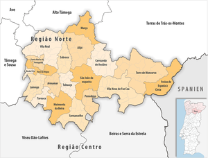
Douro is a statistical sub-region of Portugal . It is part of the Região Norte and is made up of circles from the districts of Bragança , Guarda , Vila Real and Viseu . In the north the subregion is adjacent to Alto Tâmega and Terras de Tras-os-Montes , in the east of Spain , in the south on Beiras e Serra da Estrela and Viseu Dão-Lafões , west Tâmega e Sousa in Douro and in the northwest on Ave .
The sub-region consists of 19 districts:
| circle | Number of municipalities |
Population (2011) |
Area km² |
Density of population / km² |
LAU code |
District |
|---|---|---|---|---|---|---|
| Alijó | 14th | 11,942 | 297.60 | 40 | 1701 | Vila Real |
| Armamar | 14th | 6,297 | 117.22 | 54 | 1801 | Viseu |
| Carrazeda de Ansiães | 14th | 6,373 | 279.23 | 23 | 0403 | Bragança |
| Freixo de Espada à Cinta | 4th | 3,780 | 244.15 | 15th | 0404 | Bragança |
| Lamego | 18th | 26,691 | 165.44 | 161 | 1805 | Viseu |
| Mesão Frio | 5 | 4,433 | 26.65 | 166 | 1704 | Vila Real |
| Moimenta da Beira | 16 | 10,212 | 219.95 | 46 | 1807 | Viseu |
| Murça | 7th | 5,952 | 189.37 | 31 | 1707 | Vila Real |
| Penedono | 7th | 2,952 | 133.70 | 22nd | 1812 | Viseu |
| Peso da Régua | 8th | 17.131 | 94.86 | 181 | 1708 | Vila Real |
| Sabrosa | 12 | 6.361 | 156.92 | 41 | 1710 | Vila Real |
| Santa Marta de Penaguião | 7th | 7,356 | 69.28 | 106 | 1711 | Vila Real |
| Sao João da Pesqueira | 11 | 7,874 | 266.13 | 30th | 1815 | Viseu |
| Sernancelhe | 13 | 5,671 | 228.61 | 25th | 1818 | Viseu |
| Tabuaço | 13 | 6,350 | 133.85 | 47 | 1819 | Viseu |
| Tarouca | 7th | 8,048 | 100.10 | 80 | 1820 | Viseu |
| Torre de Moncorvo | 13 | 8,572 | 531.56 | 16 | 0409 | Bragança |
| Vila Nova de Foz Côa | 14th | 7,312 | 398.14 | 18th | 0914 | Guarda |
| Vila Real | 20th | 51,850 | 378.81 | 137 | 1714 | Vila Real |
| Douro | 217 | 205.157 | 4,031.57 | 51 | 11D | - |