Alto Tâmega
| Alto Tâmega | |
|---|---|

|
|
| Basic data | |
| Country |
|
| region | Norte region |
| Capital | Guimarães |
| population | 94,143 (2013) |
| Population density | 32.2 inhabitants per km² |
| surface | 2,921.94 km² |
| Circles | 6th |
| Communities | 118 |
| ISO-3166-2 code | PT-11B |
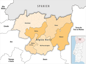
The Alto Tâmega region is a statistical sub-region of Portugal and part of the Região Norte . All counties belong to the Vila Real district . In the north, Alto Tâmega borders on Spain , in the east on Terras de Trás-os-Montes , in the south on Douro , in the south-west on Ave and in the west on Cávado .
The following circles (concelhos) are assigned to the sub-region :
| circle | Number of municipalities |
Population (2011) |
Area km² |
Density of population / km² |
LAU code |
District |
|---|---|---|---|---|---|---|
| Boticas | 10 | 5,750 | 321.96 | 18th | 1702 | Vila Real |
| Chaves | 39 | 41,243 | 591.24 | 70 | 1703 | Vila Real |
| Montalegre | 25th | 10,537 | 805.45 | 13 | 1706 | Vila Real |
| Ribeira de Pena | 5 | 6,544 | 217.47 | 30th | 1709 | Vila Real |
| Valpaços | 25th | 16,882 | 548.74 | 31 | 1712 | Vila Real |
| Vila Pouca de Aguiar | 14th | 13,187 | 437.08 | 30th | 1713 | Vila Real |
| Alto Tâmega | 118 | 94.143 | 2,921.94 | 32 | 11B | - |