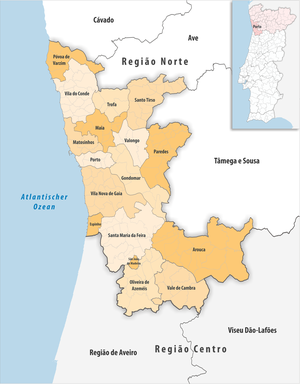
Porto metropolitan area
| Porto metropolitan area | |
|---|---|

|
|
| Basic data | |
| Country |
|
| region | Norte region |
| Capital | postage |
| population | 1,759,649 (2013) |
| Population density | 861.9 inhabitants per km² |
| surface | 2,041.63 km² |
| Circles | 17th |
| Communities | 173 |
| ISO-3166-2 code | PT-11A |
The metropolitan region of Porto ( Portuguese : Área Metropolitana do Porto , short: AMP ) is a metropolitan region in northern Portugal. It consists of 17 districts from the Aveiro and Porto districts .
The following circles (concelhos) are assigned to the sub-region :
| circle | Number of municipalities |
Population (2011) |
Area km² |
Density of population / km² |
LAU code |
District |
|---|---|---|---|---|---|---|
| Arouca | 16 | 22,359 | 329.12 | 68 | 0104 | Aveiro |
| Espinho | 4th | 31,786 | 21.05 | 1,510 | 0107 | Aveiro |
| Gondomar | 7th | 168.027 | 131.87 | 1,274 | 1304 | postage |
| Maia | 10 | 135.306 | 82.99 | 1,630 | 1306 | postage |
| Matosinhos | 4th | 175.478 | 62.43 | 2,811 | 1308 | postage |
| Oliveira de Azeméis | 12 | 68,764 | 161.39 | 426 | 0113 | Aveiro |
| Paredes | 18th | 86,854 | 156.74 | 554 | 1310 | postage |
| postage | 7th | 237,591 | 41.43 | 5,735 | 1312 | postage |
| Póvoa de Varzim | 7th | 63,408 | 82.22 | 771 | 1313 | postage |
| Santa Maria da Feira | 21st | 139,309 | 215.87 | 645 | 0109 | Aveiro |
| Santo Tirso | 14th | 71,530 | 136.61 | 524 | 1314 | postage |
| São João da Madeira | 1 | 21,685 | 7.94 | 2,731 | 0116 | Aveiro |
| Trofa | 5 | 38,999 | 72.01 | 542 | 1318 | postage |
| Vale de Cambra | 7th | 22,864 | 147.34 | 155 | 0119 | Aveiro |
| Valongo | 4th | 93,858 | 75.13 | 1,249 | 1315 | postage |
| Vila do Conde | 21st | 79,533 | 149.02 | 534 | 1316 | postage |
| Vila Nova de Gaia | 15th | 302.298 | 168.47 | 1,794 | 1317 | postage |
| Porto metropolitan area | 173 | 1,759,649 | 2,041.63 | 862 | 11A | - |