Tâmega e Sousa
| Tâmega e Sousa | |
|---|---|

|
|
| Basic data | |
| Country |
|
| region | Norte region |
| Capital | Guimarães |
| population | 432,915 (2013) |
| Population density | 236.4 inhabitants per km² |
| surface | 1,831.45 km² |
| Circles | 11 |
| Communities | 177 |
| ISO-3166-2 code | PT-11C |
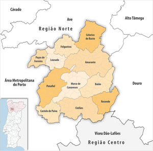
The Tâmega e Sousa region is a statistical sub-region of Portugal and part of the Região Norte . The counties belong to the districts of Aveiro , Braga , Porto and Viseu . In the north Tâmega e Sousa borders on Ave , in the east on Douro , in the south on Viseu Dão-Lafões and in the west on the metropolitan region of Porto .
The following circles (concelhos) are assigned to the sub-region :
| circle | Number of municipalities |
Population (2011) |
Area km² |
Density of population / km² |
LAU code |
District |
|---|---|---|---|---|---|---|
| Amarante | 26th | 56,264 | 301.30 | 187 | 1301 | postage |
| Baião | 14th | 20,522 | 174.52 | 118 | 1302 | postage |
| Castelo de Paiva | 6th | 16,733 | 115.00 | 146 | 0106 | Aveiro |
| Celorico de Basto | 15th | 20,098 | 181.09 | 111 | 0305 | Braga |
| Cinfães | 14th | 20,427 | 239.27 | 85 | 1804 | Viseu |
| Felgueiras | 20th | 58,065 | 115.74 | 502 | 1303 | postage |
| Lousada | 15th | 47,387 | 96.06 | 493 | 1305 | postage |
| Marco de Canaveses | 16 | 53,450 | 201.90 | 265 | 1307 | postage |
| Paços de Ferreira | 12 | 56,340 | 70.99 | 794 | 1309 | postage |
| Penafiel | 28 | 72,265 | 212.23 | 341 | 1311 | postage |
| Resende | 11 | 11,364 | 123.35 | 92 | 1813 | Viseu |
| Tâmega e Sousa | 177 | 432.915 | 1,831.45 | 236 | 11C | - |