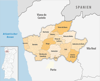
Braga district
| Braga district | |
|---|---|

|

|
| Basic data | |
| Country |
|
| Capital | Braga |
| population | 848.007 (2013) |
| Population density | 313.4 inhabitants per km² |
| surface | 2,706.12 km² |
| Circles | 14th |
| Communities | 347 |
| ISO-3166-2 code | PT-03 |
The Braga District is a district in northern Portugal . It belongs to the traditional Minho Province . It borders in the north on the district of Viana do Castelo and Spain , in the east on the district Vila Real , in the south on the district Porto and in the west on the Atlantic Ocean. It covers an area of 2673 km² and has 831,368 inhabitants (as of 2001). Its capital is Braga . License plate for trailers: BR .
Subdivision
The district of Braga is divided into the following 14 districts :
| circle | Number of municipalities |
Population (2011) |
Area km² |
Density of population / km² |
LAU code |
region | Sub-region |
|---|---|---|---|---|---|---|---|
| Amares | 16 | 18,889 | 81.96 | 230 | 0301 | Norte region | Cávado |
| Barcelos | 61 | 120.391 | 378.90 | 318 | 0302 | Norte region | Cávado |
| Braga | 37 | 181.494 | 183.42 | 989 | 0303 | Norte region | Cávado |
| Cabeceiras de Basto | 12 | 16,710 | 241.82 | 69 | 0304 | Norte region | Ave |
| Celorico de Basto | 15th | 20,098 | 181.09 | 111 | 0305 | Norte region | Tâmega e Sousa |
| Esposende | 9 | 34,254 | 95.41 | 359 | 0306 | Norte region | Cávado |
| Fafe | 25th | 50,633 | 219.08 | 231 | 0307 | Norte region | Ave |
| Guimarães | 48 | 158.088 | 240.93 | 656 | 0308 | Norte region | Ave |
| Póvoa de Lanhoso | 22nd | 21,918 | 134.66 | 163 | 0309 | Norte region | Ave |
| Terras de Bouro | 14th | 7,253 | 277.45 | 26th | 0310 | Norte region | Cávado |
| Vieira do Minho | 16 | 13.001 | 216.44 | 60 | 0311 | Norte region | Ave |
| Vila Nova de Famalicao | 34 | 133,753 | 201.59 | 663 | 0312 | Norte region | Cávado |
| Vila Verde | 33 | 47,789 | 228.68 | 209 | 0313 | Norte region | Cávado |
| Vizela | 5 | 23,736 | 24.69 | 961 | 0314 | Norte region | Ave |
| Braga district | 347 | 848.007 | 2,706.12 | 313 | 03 | - | - |
In the current subdivision of Portugal, the entire Braga district is assigned to the Região Norte region .