
Terras de Bouro
| Terras de Bouro | ||||||
|---|---|---|---|---|---|---|
|
||||||
| Basic data | ||||||
| Region : | Norte | |||||
| Sub-region : | Cávado | |||||
| District : | Braga | |||||
| Concelho : | Terras de Bouro | |||||
| Coordinates : | 41 ° 43 ′ N , 8 ° 19 ′ W | |||||
| Residents: | 7253 (as of June 30, 2011) | |||||
| Surface: | 277.45 km² (as of January 1, 2010) | |||||
| Population density : | 26 inhabitants per km² | |||||
| Postal code : | 4840 | |||||
| Terras de Bouro county | ||||||
|
||||||
| Residents: | 7253 (as of June 30, 2011) | |||||
| Surface: | 277.45 km² (as of January 1, 2010) | |||||
| Population density : | 26 inhabitants per km² | |||||
| Number of municipalities : | 14th | |||||
| administration | ||||||
| Administration address: | Câmara Municipal de Terras de Bouro Largo do Município 4840-100 Terras de Bouro |
|||||
| President of the Câmara Municipal: | Joaquim José Cracel Viana | |||||
| Website: | www.cm-terrasdebouro.pt | |||||


.jpg)
Terras de Bouro is a small town ( vila ) in Portugal with about 800 inhabitants. It is the seat of a district of the same name, which is known for its near-natural tourism, in particular for the thermal baths and hiking trails in the Peneda-Gerês National Park , and the water sports in its rivers and lakes.
history

The place name goes back to the Germanic tribe of the Buri who came to the Iberian Peninsula with the Suebi in the early 5th century and settled here in the area between the Cávado and Homem rivers . The Romans had previously lived here , who built a Roman road here and frequented the thermal springs in what is now the Peneda-Gerês National Park . A significant number of Roman milestones, the miliaria, were found here. An application for the monuments to be included in the UNESCO World Heritage List is in progress. The Roman road connected Bracara Augusta (now Braga , Portugal) with Asturica Augusta (now Astorga , Spain).
After the Suebi, Visigoths and other Germanic tribes subjugated the Romans from the 5th century onwards, the Moors conquered the Iberian Peninsula from 711 and also the current district area. During the Reconquista , the place was repopulated as part of the settlement policy under King D. Dinis . King D. Manuel gave Terras de Boyro town rights in 1514 . The current spelling of the place developed in the following epochs.
administration
The circle
Terras de Bouro is the seat of a district of the same name ( concelho ) in the Braga district . On June 30, 2011 the district had 7253 inhabitants on an area of 277.5 km².
The district borders (clockwise from the north) on Ponte da Barca , Spain , Montalegre , Vieira do Minho , Amares and Vila Verde .
With the regional reform in September 2013 , several municipalities were merged into new municipalities, so that the number of municipalities decreased from 17 to 14.
The Terras de Bouro county is divided into the following communes ( Freguesias ):

| local community | Population (2011) |
Area km² |
Density of population / km² |
LAU code |
|---|---|---|---|---|
| Balança | 341 | 3.76 | 91 | 031001 |
| Campo do Geres | 162 | 68.76 | 2 | 031003 |
| Carvalheira | 386 | 9.05 | 43 | 031004 |
| Chamoim e Vilar | 440 | 12.57 | 35 | 031018 |
| Chorense e Monte | 580 | 20.26 | 29 | 031019 |
| Cibões e Brufe | 421 | 24.03 | 18th | 031020 |
| Covide | 343 | 18.09 | 19th | 031008 |
| Gondoriz | 295 | 7.40 | 40 | 031009 |
| Moimenta | 741 | 3.35 | 221 | 031010 |
| Ribeira | 242 | 2.25 | 108 | 031012 |
| Rio Caldo | 892 | 13.95 | 64 | 031013 |
| Souto | 494 | 4.03 | 123 | 031014 |
| Valdosende | 630 | 12.12 | 52 | 031015 |
| Vilar da Veiga | 1,286 | 77.83 | 17th | 031017 |
| Terras de Bouro county | 7,253 | 277.45 | 26th | 0310 |
Population development
| Population in Terras de Bouro County (1801–2011) | |||||||||
|---|---|---|---|---|---|---|---|---|---|
| 1801 | 1849 | 1900 | 1930 | 1960 | 1981 | 1991 | 2001 | 2011 | |
| 4091 | 5615 | 8436 | 10.206 | 11,762 | 10.131 | 9406 | 8350 | 7282 | |
Municipal holiday
- the 20th of October
Town twinning
-
 Saint-Arnoult-en-Yvelines , France
gallery

Seascape (Barragem da Caniçada)
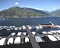
Marina with excursion boat on the Rio Caldo

At the Vila do Gerês thermal baths

At the Cascata do Arado waterfall

View from the Pousada de São Bento

Traditional granaries ( espigueiros ) in Terras de Bouro county

Village ruins at the Vilarinho de Furnas reservoir


Web links
- Map of the Concelho Terras de Bouro at the Instituto Geográfico do Exército
- Official website of the city administration
Individual evidence
- ↑ a b c www.ine.pt - indicator resident population by place of residence and sex; Decennial in the database of the Instituto Nacional de Estatística
- ↑ a b Overview of code assignments from Freguesias on epp.eurostat.ec.europa.eu
- ↑ www.verportugal.net , accessed February 15, 2014
- ^ Publication of the administrative reorganization in the Diário da República gazette of January 28, 2013, accessed on March 16, 2014
- ↑ www.anmp.pt , accessed on February 15, 2014
